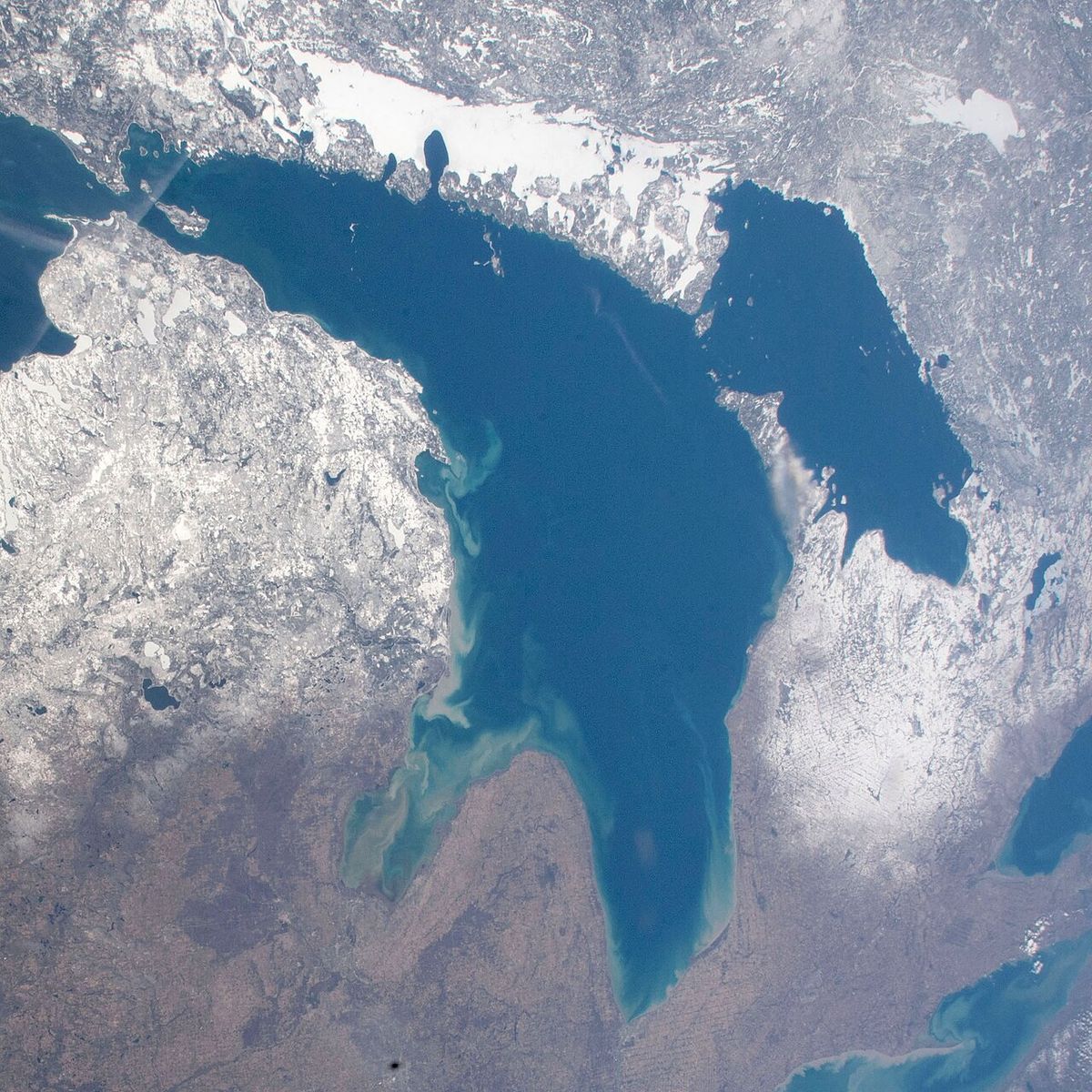
1996 Lake Huron cyclone
The 1996 Lake Huron cyclone, often called Hurricane Huron or Hurroncane, was an extremely rare and strong cyclonic storm that developed directly over Lake Huron in September 1996. This storm was unique in meteorological history as the first recorded system to form over the Great Lakes region with characteristics resembling a subtropical or tropical cyclone. Its development was completely independent of any precursor tropical systems, unlike other storms that have affected the region. The cyclone brought significant rainfall and flooding to parts of Ontario and the northeastern United States, highlighting the potential for severe weather to originate from the Great Lakes themselves.
Meteorological History and Development
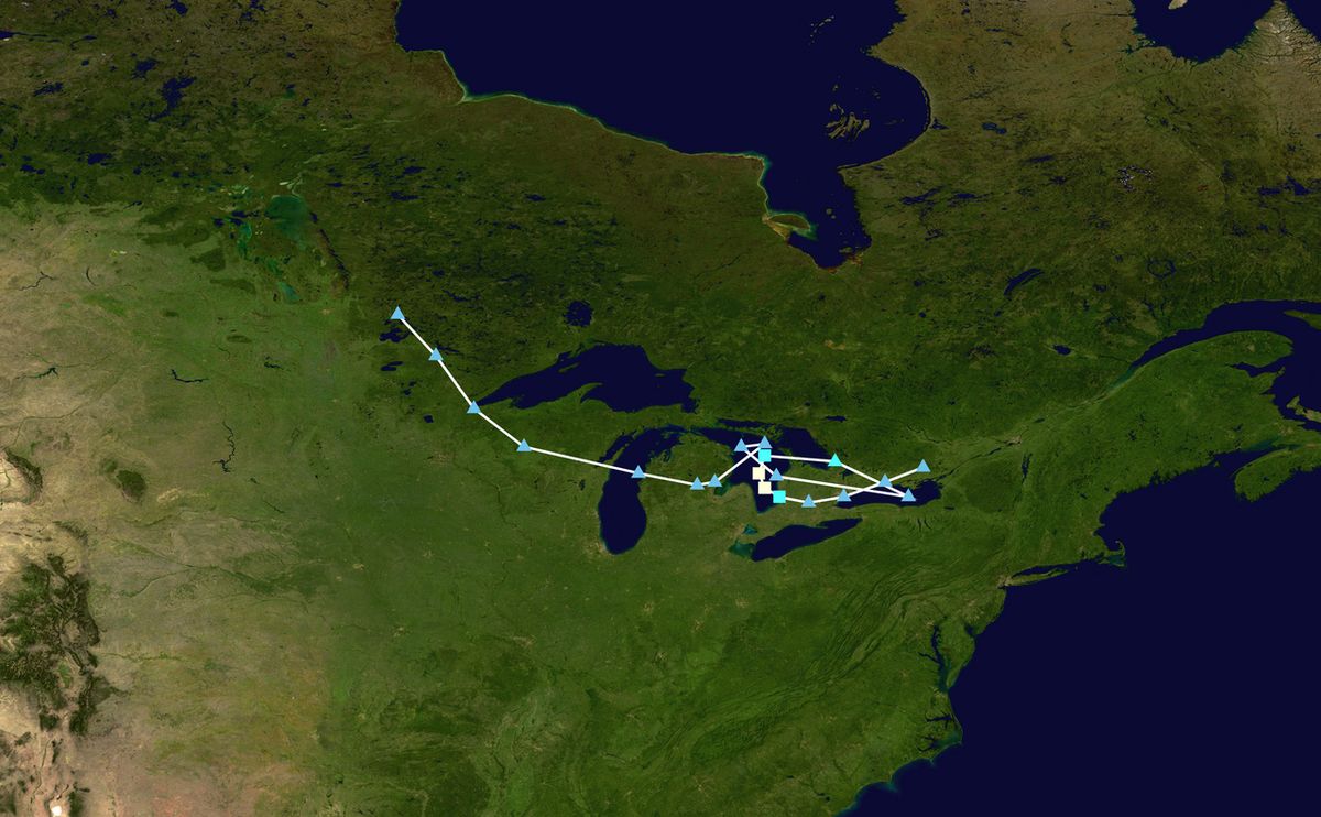
The genesis of the 1996 Lake Huron cyclone began on September 11, 1996, with a weak low-pressure area situated near Lake Superior and a shortwave trough over Ontario. The initial storm centre was over Lake Michigan with a central pressure of 1012 mbar. Meteorological analysis indicated the surface centre was strengthening due to baroclinic forcing, and the cyclone's circulation extended into the upper troposphere. Over the next 24 hours, the system was steered by a cold front to a position over Lake Huron, where its central pressure fell to 1006 mbar. The cyclone's lower levels experienced the most intense development as it became more vertically organized while moving southeastward over the lake.
By September 13, the connected cold front had become an occluded front stretching from Lake Huron to Pennsylvania, with a 155-mile swath of showers and thunderstorms. A key intensification phase occurred between September 13 and 14, when the mid-level circulation centred itself just east of Lake Huron and the surface circulation began to align with it, deepening to 999 mbar. The storm then underwent a remarkable transformation as baroclinic processes weakened and the system became more shallow, yet the low-level circulation intensified dramatically. The central pressure dropped to 992 mbar, and the cyclone reached its peak intensity with maximum sustained winds of 73 mph, equivalent to a high-end tropical storm and on the threshold of a Category 1 hurricane.
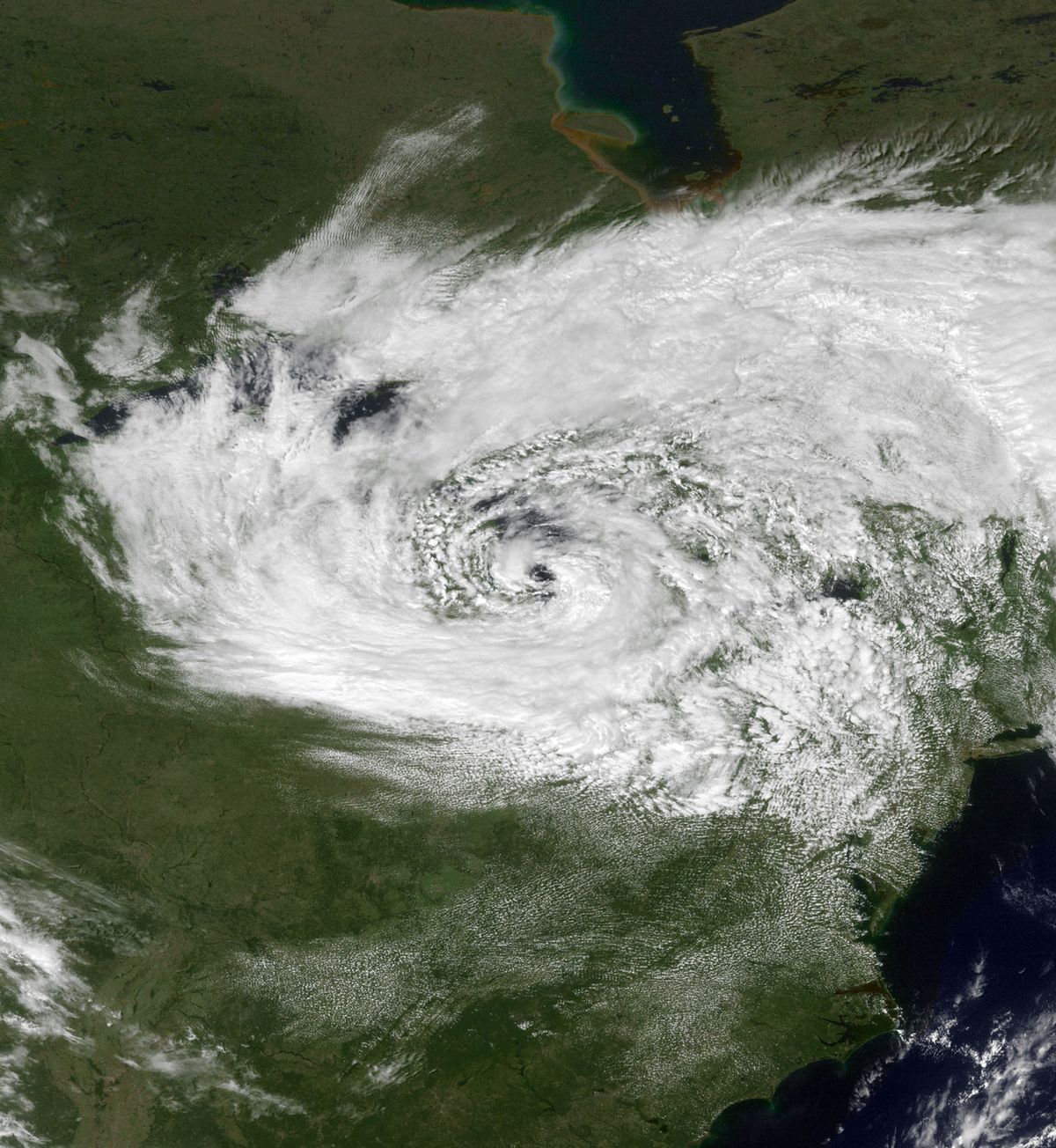
Visible satellite imagery from September 14 revealed the storm's most distinctive features, making it resemble a subtropical cyclone. It developed an eye-like feature approximately 19 miles wide, surrounded by convective clouds forming an eyewall, similar to structures seen in tropical cyclones. Bands of convection extended westward for about 310 miles. However, this organized structure was short-lived as prevailing winds shifted to the east-northeast, introducing shear that rapidly weakened the system. The cyclone decayed mainly in the lower troposphere, with air pressure rising at all levels. By September 15, it had weakened into a remnant low and left Lake Huron, dissipating soon afterward.
Impact and Aftermath
The primary impact of the 1996 Lake Huron cyclone was heavy rainfall across the Great Lakes basin. Excessive rain totals exceeding 4 inches fell over land surrounding the lakes, with Ontario, New York, and Indiana all receiving over 2 inches of precipitation. This intense rainfall triggered flooding in specific areas. In the United States, flooding occurred around Buffalo, New York, while on the Canadian side, the eastern shore of Lake Huron in Ontario experienced similar issues. Despite the significant precipitation and resultant flooding, there were no reports of fatalities linked directly to the storm. Beyond the flood damage, no other significant structural damage or injuries were widely reported, making the event notable more for its meteorological rarity than for its destructive power. The storm also generated high waves on Lake Erie as it weakened and moved through the region. The flooding events served as a reminder of the hydrological hazards that can accompany intense low-pressure systems over the Great Lakes, even those not originating from traditional tropical sources. The 1996 cyclone's legacy is thus firmly rooted in its unique formation and structure rather than in a history of widespread devastation. Its impact was primarily hydrological, causing temporary flooding but no loss of life or major infrastructure damage.
Historical Context of Great Lakes Storms
The Great Lakes region has a history of experiencing the remnants of hurricanes that originally made landfall along the Gulf of Mexico or the Atlantic coast of the United States. Very few of these systems retain any tropical characteristics by the time they reach the inland lakes. The strongest impacts typically result from interactions between a hurricane remnant and an extratropical weather system. Only two other documented storms are known to have produced hurricane-force winds over the Great Lakes prior to 1996. The 1996 Lake Huron cyclone stands apart from all these events because it developed its hybrid tropical characteristics over the lakes themselves, independent of any precursor tropical cyclone.
Notable historical storms that affected the region include the remnant of the 1941 Texas hurricane, which merged with a strong cold front. That system produced hurricane-force winds over Lake Huron and Lake Ontario in September, with steady winds of 56 mph reported in Detroit. It caused multiple deaths, half of which occurred in Toronto, and injuries from blown-out windows in Detroit. Although it had lost much intensity overland, it interacted with a trough near Lake Erie, explosively strengthening to Category 1 equivalent winds in Canada, with most damage stemming from extreme rainfall on saturated ground.
Other storms have made a tropical landfall in the Great Lakes region, though without hurricane-force winds. These include the Great Charleston hurricane of 1893, the Georgia hurricane of 1898, Hurricane Connie in 1955, and Hurricane Fran, which also occurred in 1996. The concurrent occurrence of Hurricane Fran and the Lake Huron cyclone in the same season shows the variety of storm threats the region can face. The following list highlights key storms that have significantly impacted the Great Lakes region.
- 1941 Texas Hurricane Remnant (September 1941): Produced hurricane-force winds over Lakes Huron and Ontario, causing deaths in Toronto.
- Hurricane Connie (August 1955): Made tropical landfall in the Great Lakes region, bringing heavy rain.
- Hurricane Fran (September 1996): Another 1996 storm that reached the Great Lakes with tropical characteristics.
- 1996 Lake Huron Cyclone (September 1996): The unique storm that developed tropical traits directly over Lake Huron.
Scientific Analysis and Classification
The 1996 Lake Huron cyclone presented a significant case study for meteorologists due to its hybrid nature. Analysis published in the Monthly Weather Review in 2001 referred to the storm as "Hurricane Huron" and detailed it as an extreme example of a lake-aggregate effect. The study concluded the system resembled a subtropical cyclone at its peak, possessing multiple characteristics of a tropical cyclone while maintaining some hybrid, extratropical traits. Key tropical features observed included a warm core, organized convection around a centre, and the formation of an eye-like feature and eyewall. However, the storm also derived energy from baroclinic sources and frontal boundaries, classic of extratropical systems.
Computer modelling conducted by institutions like Argonne National Laboratory has used the event to study climate modelling at the regional scale and to simulate the unusual conditions that led to its development. The storm's intensification was linked to the warm waters of Lake Huron in early September, when lake surface temperatures are at their annual peak. This heat and moisture acted as an energy source, allowing the low-pressure system to transition toward a more tropical structure. The vertical stacking of the cyclone's circulation layers was identified as a critical factor that made the storm ripe for this atypical development. Its lowest recorded central pressure was 992 mbar. The rapid weakening was attributed to increased vertical wind shear and the system's movement away from the primary heat source of the lake. The event demonstrated that under specific atmospheric conditions, the Great Lakes are capable of fostering storm systems with tropical characteristics, challenging traditional assumptions about where such cyclones can form.
Comparative Storm Statistics
The 1996 Lake Huron cyclone was an extremely rare, strong cyclonic storm system that developed over Lake Huron in September 1996. It developed tropical characteristics over the Great Lakes region completely independent of precursor tropical cyclones. This makes it unique among Great Lakes storms. Very few storms have retained any tropical characteristics by the time they reached the Great Lakes. Only two such storms had hurricane-force winds over the Great Lakes.
| Storm | Year | Origin | Peak Winds over Lakes | Primary Impact |
|---|---|---|---|---|
| 1941 Texas Hurricane Remnant | 1941 | Gulf of Mexico | Hurricane-force | Wind damage, fatalities |
| Hurricane Connie | 1955 | Atlantic | Tropical storm force | Heavy rainfall |
| Hurricane Fran | 1996 | Atlantic | Tropical storm force | Rainfall |
| 1996 Lake Huron Cyclone | 1996 | Lake Huron | 73 mph (High-end tropical storm) | Localized flooding |
The data shows that while other storms brought hurricane-force winds, they all originated as classical tropical cyclones over ocean basins. The 1996 cyclone is the only one whose genesis was directly over the freshwater of the Great Lakes. Its peak intensity was comparable to a strong tropical storm, but its impact was less severe than the deadly winds of the 1941 remnant or the flooding from Hazel. This comparison reveals the different types of severe weather threats in the Great Lakes region, which can include both imported tropical systems and homegrown hybrid cyclones.

Legacy and Significance in Meteorology
The 1996 Lake Huron cyclone holds a permanent place in meteorological history as a groundbreaking event. It proved that the Great Lakes, under the right autumnal conditions, can serve as a breeding ground for storms with subtropical or tropical characteristics. This expanded the scientific understanding of where such cyclones can develop, moving beyond traditional oceanic basins. The event is frequently cited in academic literature and meteorological discussions as a classic case study of a lake-aggregate cyclone or a "hurricane-like" lake storm. It prompted further research into the potential for similar events in the future, especially as lake temperatures fluctuate with climate change.
For emergency management and the public in the Great Lakes region, the storm serves as an educational example that dangerous weather systems can originate locally and rapidly intensify. While the damage was limited, the event highlighted vulnerabilities to heavy rainfall and flooding along lake shores. The storm's popular nicknames, "Hurricane Huron" and "Hurroncane," have endured in regional weather folklore, symbolizing the unexpected power of the lakes. It remains a key reference point when discussing extreme weather potential in the interior of North America.
The system resembled a subtropical cyclone at its peak, bearing some characteristics of a tropical cyclone. It was the first time such a storm has ever been recorded forming over the Great Lakes region. The cyclone developed over the Great Lakes in September, when the lakes are at their warmest. It reached a peak intensity with maximum sustained winds of 73 miles per hour, equivalent to a high-end tropical storm.
Questions about 1996 Lake Huron cyclone
What was the 1996 Lake Huron cyclone?
The 1996 Lake Huron cyclone was an extremely rare and strong cyclonic storm that developed directly over Lake Huron in September 1996. It was the first recorded storm to form over the Great Lakes region with characteristics resembling a subtropical or tropical cyclone, including an eye-like feature and an eyewall. At its peak, it had sustained winds of 73 mph, equivalent to a high-end tropical storm. The storm was unique because it developed independently, without originating from a tropical system in the ocean.
What damage did the storm cause in Canada?
In Canada, the primary impact was heavy rainfall and subsequent flooding along the eastern shore of Lake Huron in Ontario. The storm dropped over 4 inches of rain in some areas surrounding the Great Lakes. While this caused localized flooding, there were no reports of fatalities or significant structural damage directly attributed to the storm in Canada. The event was more notable for its meteorological rarity than for being a major disaster, especially when compared to historically damaging storms like Hurricane Hazel.
Could a storm like this happen again on the Great Lakes?
Yes, meteorological research indicates that a similar storm could potentially happen again. The conditions required include a deep, warm lake (typically in early autumn), a pre-existing low-pressure system, and favourable atmospheric dynamics that allow the storm to become vertically organized and draw energy from the lake's heat. Climate change, which may influence lake surface temperatures and weather patterns, could affect the frequency or intensity of such events. However, the specific combination of factors that created the 1996 cyclone remains rare.
Why is the storm significant to meteorology?
The storm is highly significant because it challenged conventional understanding of where cyclones with tropical characteristics can form. It demonstrated that large, warm inland bodies of water like the Great Lakes are capable of fostering such development. The event became a crucial case study for understanding hybrid subtropical cyclones and lake-aggregate weather effects. It prompted advanced computer modelling and research, improving the scientific community's ability to forecast and recognize similar unusual storms in the future, not just in the Great Lakes but potentially in other large inland seas globally.
Was it actually a hurricane?
No, the 1996 Lake Huron cyclone was not officially classified as a hurricane. Visible satellite imagery revealed the storm resembled a subtropical cyclone, possessing multiple characteristics of a tropical cyclone while also having hybrid traits. It displayed an eye like feature about 19 miles wide and convective clouds forming an eyewall. However, it developed independently over Lake Huron in September 1996, making it a unique and extremely rare event for the Great Lakes region.
How does this storm compare to Hurricane Hazel?
The 1996 Lake Huron cyclone and Hurricane Hazel were fundamentally different storms. In contrast, the 1996 cyclone developed tropical characteristics over the Great Lakes completely independent of any precursor tropical cyclone. While Hazel caused extreme rainfall and significant damage, the Lake Huron cyclone's main impact was excessive rain causing flooding in areas like Buffalo, New York, and eastern Lake Huron in Ontario, with no reports of fatalities. The 1996 storm is unique for forming directly over the lakes, whereas Hazel was a remnant of a hurricane.
Sources and further reading
- 1996 Lake Huron cyclone (Wikipedia)
- “Hurricane Huron”: An Example of an Extreme Lake ... (journals.ametsoc.org)
Checked by the Your Space Hamilton desk. Last updated 2026-10-22.