Hurricane Hazel
Hurricane Hazel was the deadliest and most intense hurricane of the 1954 Atlantic hurricane season, causing catastrophic damage across the Caribbean and the eastern United States before striking Canada as a powerful extratropical storm. The hurricane's impact on Canada was unprecedented, particularly in Toronto, where it caused severe flooding that resulted in 81 deaths and over C$135 million in damage, a sum equivalent to about C$1.6 billion in 2025. The storm's legacy led to significant changes in floodplain management and disaster preparedness in Ontario. Its name was permanently retired from the list of North Atlantic hurricane names due to the extensive destruction and loss of life.
Meteorological History
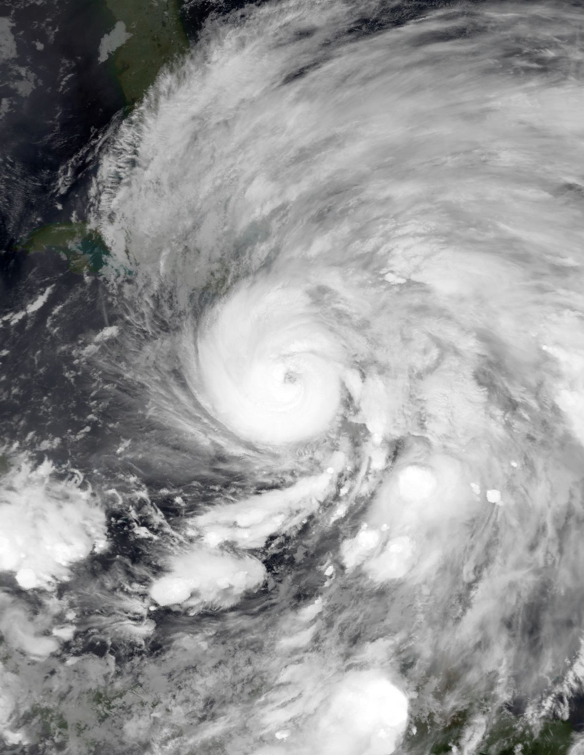
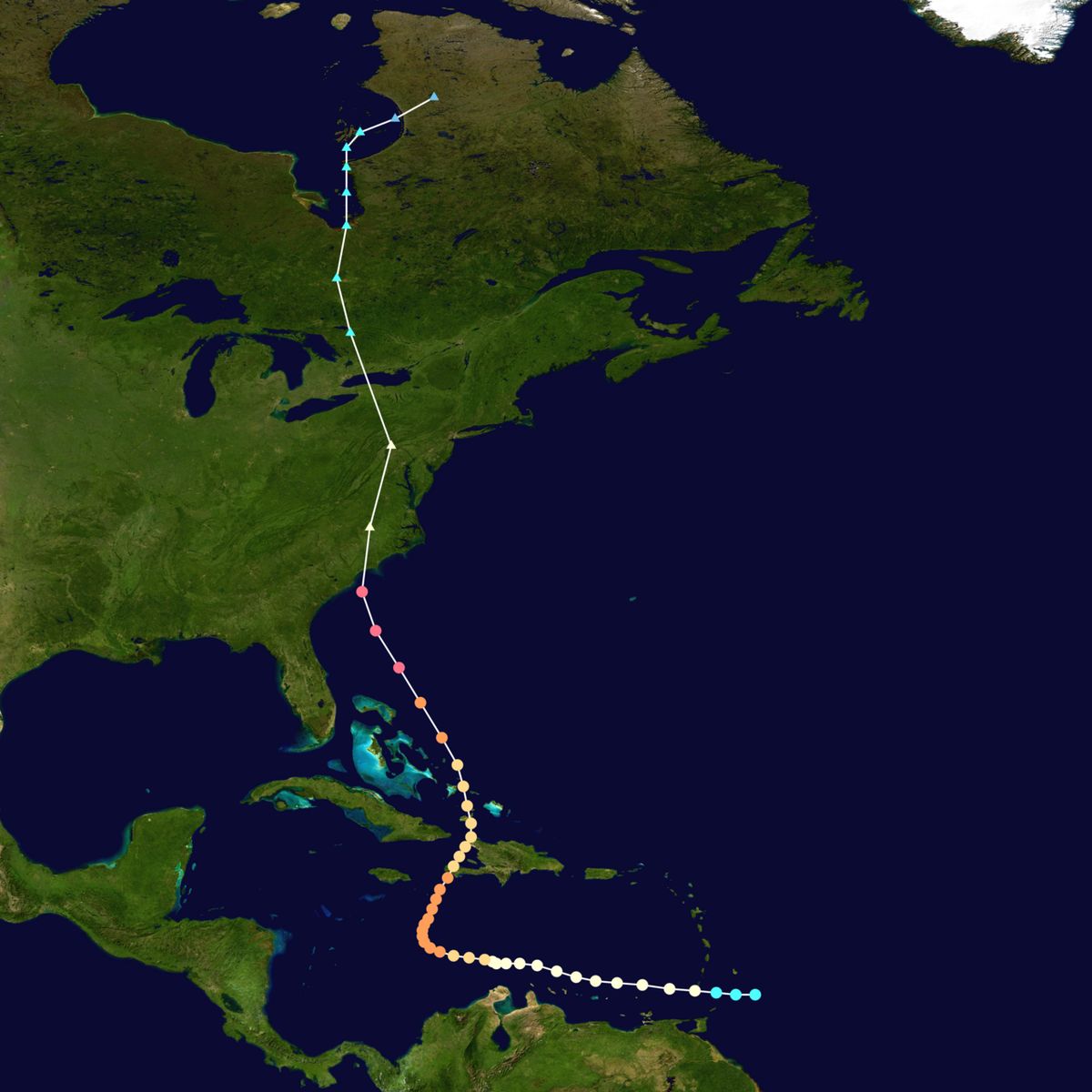
Hurricane Hazel originated from a tropical wave that was first identified approaching the Lesser Antilles on October 5, 1954. A reconnaissance flight from San Juan, Puerto Rico, confirmed the system's development into a tropical cyclone about 30 miles east of Grenada. The Atlantic hurricane reanalysis later determined Hazel officially developed at 06:00 UTC on October 5, roughly 220 miles east of Grenada. Initially, reconnaissance planes observed hurricane-force winds, but the storm's small eye and relatively high central pressure led to a downward revision of its intensity to 65 mph winds by late on October 5. The storm was estimated to have reached hurricane status by 00:00 UTC on October 6, coinciding with its landfall on Grenada with winds of 75 mph. After entering the Caribbean Sea, Hazel maintained a compact structure as it moved westward, gradually intensifying parallel to the northern coast of Venezuela.
By October 8, Hazel's eye had expanded and its winds increased, with estimates as high as 125 mph. A Hurricane Hunters flight that day encountered severe turbulence, injuring two crew members and hospitalizing one. The storm's core went unmonitored by aircraft for five days thereafter, though radar imagery indicated the eye became open and ragged. Late on October 9, Hazel intensified into a major hurricane, a Category 3 storm with winds of 115 mph, a fact confirmed by aircraft observations on October 10. Steering currents then directed Hazel sharply north-northeast toward Hispaniola. At 09:00 UTC on October 12, the hurricane made landfall near Chardonnières on Haiti's Tiburon Peninsula as a Category 3 hurricane with estimated sustained winds of 120 mph. After crossing the Gulf of Gonâve, Hazel made a second landfall in northwestern Haiti near Baie-de-Henne at 00:00 UTC on October 13 as a Category 2 storm with 100 mph winds.
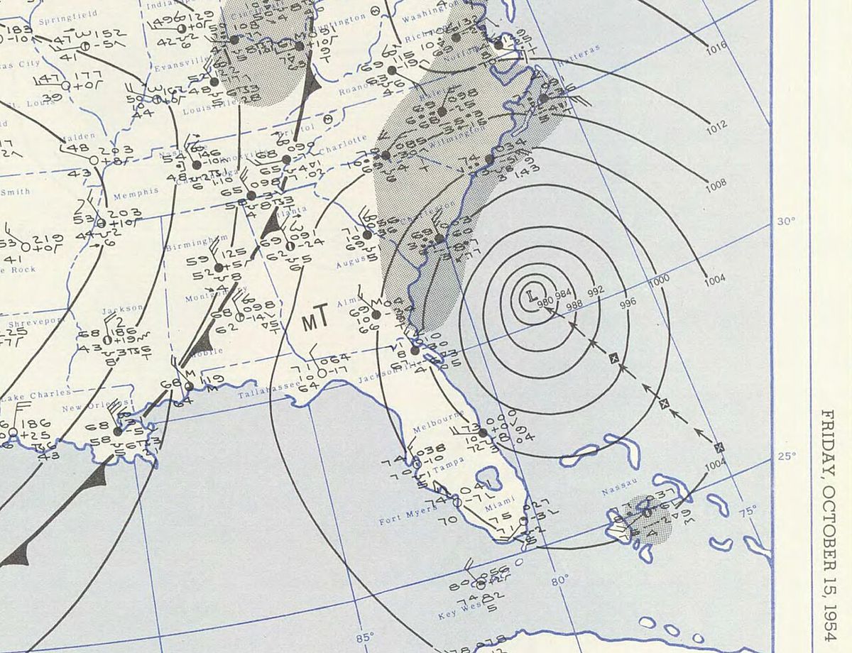
Curving north and northwest due to an approaching trough, Hazel then struck Inagua in the Bahamas with 100 mph winds at 14:00 UTC on October 13. Accelerating northwestward toward the southeastern United States, the hurricane defied expectations by restrengthening over the warm Gulf Stream waters. On October 15, a ship off South Carolina reported a central pressure of 938 mbar, the lowest recorded in association with Hazel. At 15:30 UTC that day, Hazel made landfall just west of the North Carolina-South Carolina border, near Myrtle Beach, as a large Category 4 hurricane with estimated winds of 130 mph. The storm's eye was tracked across several North Carolina towns as it continued northward. By 18:00 UTC on October 15, near Raleigh, Hazel transitioned into an extratropical cyclone, merging with a cold front.
Its remnants accelerated north through Pennsylvania and New York. There is some meteorological debate regarding the continuity of its circulation during this phase, with the Canadian weather service positing a new circulation formed over western New York. On October 16, the storm crossed into Ontario and stalled over the Toronto region, retaining power equivalent to a Category 1 hurricane despite having travelled nearly 1,000 kilometres over land. The storm finally weakened to gale force, turned northward over James Bay on October 17, and its remnants were absorbed by a larger extratropical system over northern Quebec on October 18.
Preparations and Warnings
Initial preparations for Hazel began in the Caribbean. On October 6, small craft warnings were issued for the Dutch ABC islands of Aruba, Bonaire, and Curaçao, though these were cancelled a day later as the storm passed to the north. As Hazel turned northward, tropical cyclone warnings were posted for Haiti, the Dominican Republic, and the Mona Passage. Small craft near Jamaica were advised to seek port, and the U.S. Navy at Guantanamo Bay undertook extensive preparations, securing aircraft, ships, and moving about 1,000 civilians into fortified shelters. In the United States, the Weather Bureau issued a warning for the Carolinas on October 14, initially expecting the worst of the hurricane to remain offshore. The forecast changed rapidly as Hazel took a sharp northwest turn toward land, with evening updates predicting landfall near the Carolinas border. Subsequent forecasts incorrectly anticipated the storm would lose power and dissipate over the Allegheny Mountains.
Preparations in Canada were minimal and ultimately insufficient. The Dominion Weather Office issued two Special Weather Bulletins, but the general forecast predicted the storm would pass east of Toronto, bringing high winds of only 65 to 80 km/h and occasional showers. Few other warnings were issued, and no evacuations were ordered. Toronto Hydro called in standby crews in anticipation of heavy winds but nearly sent them home during a temporary lull. As noted by Canadian journalist Betty Kennedy in her book Hurricane Hazel, the event was paradoxically both a well-documented meteorological occurrence and a surprise, as few in Toronto had experience with hurricanes. The public and authorities were unprepared for a tropical system to retain such strength so far inland. The ground was already saturated from significant rainfall in the two preceding weeks, setting the stage for disastrous flooding when Hazel's unprecedented rainfall arrived.
Impact in the Caribbean
Hazel's first impacts were felt in the Caribbean, where it caused significant damage and loss of life. The ABC islands of Aruba, Bonaire, and Curaçao experienced rough winds and up to 250 mm of rain, causing flash floods that destroyed a bridge and several water dams, resulting in $350,000 in losses. Puerto Rico suffered its worst flooding since 1899, leading to the evacuation of over 11,000 people. Timely warnings limited the death toll to nine, but infrastructure and agriculture sustained serious damage. Haiti bore the brunt of the hurricane's Caribbean fury. Hazel made two landfalls on the country, bringing flash floods that destroyed numerous villages and high winds that damaged major cities. The death toll in Haiti was estimated to be as high as 1,000, with most victims drowning in floodwaters rushing down deforested mountainsides.
The storm's impact on Haiti's economy was severe and long-lasting. The South Peninsula was hardest hit, with the town of Aux Cayes reporting at least 200 casualties and an estimated $500,000 in damage. Reports indicated the town of Jérémie was 'swept into the sea,' with at least 200 more lives lost. Up to 100,000 people were left homeless. Crucially, Hazel destroyed about 40 percent of the nation's coffee trees and 50 percent of its cacao crop, affecting the economy for several years. Elsewhere, hurricane-force winds affected eastern Cuba, killing one fisherman. Damage in the Bahamas was minor, though Hazel directly passed over Inagua, where six people died when a sailboat capsized.
Impact in the United States
Hurricane Hazel struck the United States with devastating force, primarily in the Carolinas. In South Carolina, a storm surge of 3.0 to 3.4 metres flooded coastal areas, destroying hundreds of buildings, including about 80 percent of waterfront dwellings in Myrtle Beach. Two piers were damaged, and a three-story hotel and a 240-metre pier in North Myrtle Beach were washed out to sea. One death occurred in the state, with total damage reaching about $27 million. North Carolina suffered even greater destruction. A storm surge exceeding 5.5 metres, coinciding with the year's highest lunar tide, annihilated coastal communities. In Brunswick County, most coastal dwellings were destroyed or severely damaged. At Long Beach, only five of 357 buildings were left standing. The Weather Bureau in Raleigh stated that 'all traces of civilization on the immediate waterfront' between the state line and Cape Fear were 'practically annihilated,' and every pier along 270 kilometres of coastline was demolished.
Wind gusts reached an estimated 190 km/h in inland cities like Kinston and Goldsboro, causing widespread damage to forests and property from falling trees. The heavy rainfall, however, was welcome relief from a severe drought, with Robbins, North Carolina, receiving 286 mm. The storm killed 19 people in North Carolina, injured hundreds, destroyed 15,000 homes, and damaged 39,000 more. Damage in the Carolinas totalled $163 million. As Hazel moved north as an extratropical storm, it retained hurricane-strength winds. Virginia recorded gusts over 160 km/h in Norfolk, which knocked over a microwave tower in Warsaw and left about 50 percent of residents without power or telephone service for six days. Twelve people died in Virginia, with damage around $15 million. The storm then affected West Virginia, Maryland, Delaware, New Jersey, Pennsylvania, and New York, causing widespread power outages and felling trees.
- Record Wind in New York: A gust of 182 km/h was recorded at Battery Park, the highest wind speed ever recorded within New York City's municipal boundaries.
- Heavy Rainfall: West Virginia received an average of 230 mm of rain, with localized amounts reaching 300 mm in the Appalachians.
- Flooding: Considerable flooding was reported in the Washington, D.C. area, Maryland, and Virginia, flooding parts of the U.S. Naval Academy in Annapolis.
- Structural Damage: In Pennsylvania, winds were strong enough to unroof homes, and in Elmira, New York, the 150-metre tower of television station WTVE was toppled, taking the station off the air for 19 months.
Hurricane Hazel caused extensive financial damage in the United States. The total monetary impact of the storm in the country ranged from $281 million to $308 million in 1954 United States dollars. This damage was incurred across multiple states along the Atlantic coast. The Carolinas alone suffered damages amounting to $163 million, with $61 million of that affecting beachfront property.
Impact and Aftermath in Canada
Hazel arrived in Ontario on October 16 as a powerful extratropical storm, stalling over the Greater Toronto Area. The combination of the storm's retained intensity, the already saturated ground from weeks of prior rain, and a lack of public awareness led to catastrophic flooding. Rivers and streams, including the Humber River, Don River, and Etobicoke Creek, overflowed their banks. The Raymore Drive area was among the hardest hit, where entire homes were swept away. In total, 81 people lost their lives in Canada, all in Ontario and mostly in Toronto. Property damage exceeded C$135 million (1954 dollars), equivalent to approximately C$1.6 billion in 2025. The storm's unprecedented nature in Canada was highlighted by the mobilization of 800 military personnel to assist with cleanup and the establishment of a Hurricane Relief Fund that distributed $5.1 million in aid (about $61.1 million in 2025).
The disaster prompted a fundamental re-evaluation of urban planning and disaster management. In the aftermath, many residential areas built on floodplains were deemed too hazardous to rebuild. These lands, such as the Raymore Drive neighbourhood, were subsequently expropriated and converted into public parkland, creating an extensive network of green spaces along Toronto's river valleys. The tragedy directly led to the formation of the Toronto and Region Conservation Authority (TRCA) with strengthened powers to regulate development in flood-prone areas. New zoning bylaws were enacted to restrict construction on floodplains, and a major program of flood control infrastructure, including dams and channel improvements, was initiated. The event remains a seminal moment in Canadian environmental and urban history, fundamentally changing how municipalities across the country approach watershed management and emergency preparedness for extreme weather.
Comparative Impact Statistics
Hurricane Hazel had a widespread and severe impact across several regions. The storm was the deadliest hurricane of the 1954 Atlantic season, killing at least 469 people in Haiti. It then caused 95 fatalities in the United States before striking Canada as an extratropical storm, which raised the death toll by 81 people, mostly in Toronto. The financial damage was also immense, with over C$135 million in damage incurred in Canada alone, which would be equivalent to about C$1.6 billion in 2025.
| Region | Fatalities | Key Damage Figures (1954) |
|---|---|---|
| Haiti | At least 469 | 40% coffee trees, 50% cacao crop destroyed. Up to 100,000 homeless |
| United States (Total) | 95 | $281 to 308 million |
| , Virginia | 12 | ~$15 million. 18,000 homes/businesses damaged |
| Canada (Ontario) | 81 | >C$135 million (~C$1.6B 2025). Widespread flooding |
| Other Caribbean | 16+ (9 PR, 6 Bahamas, 1 Cuba) | $350,000 in ABC islands. Severe flooding in Puerto Rico |
Retirement and Legacy
Due to the extreme loss of life and destruction, the name 'Hazel' was retired from the rotating list of names for North Atlantic hurricanes, ensuring it would never be used again for a future storm. This established a precedent for the retirement of particularly notable hurricane names. In Canada, Hazel's legacy is deeply embedded in public policy and collective memory. The storm exposed critical vulnerabilities in urban development and disaster response. The transformation of floodplain neighbourhoods into parkland served as a tangible and lasting memorial to the victims while providing essential environmental benefits. The strengthened conservation authorities became models for watershed management. Hurricane Hazel is frequently cited in discussions about climate change and urban resilience, serving as a stark reminder of the potential for extreme tropical weather systems to impact regions far from the coast. It is Canada's deadliest and most costly hurricane-related disaster, a key event that reshaped approaches to environmental planning and public safety.
Questions about Hurricane Hazel
Why was Hurricane Hazel so devastating in Toronto?
Hurricane Hazel was devastating in Toronto due to a confluence of unusual factors. The ground was already saturated from weeks of heavy rainfall prior to the storm. Hazel itself retained hurricane-strength winds and dumped enormous amounts of rain as an extratropical system, stalling over the region. Crucially, few warnings were issued as forecasts predicted the storm would pass east of the city with only moderate winds, and the population had no experience with hurricanes travelling so far inland. This lack of preparedness, combined with extensive residential development on floodplains, led to the catastrophic flooding that claimed 81 lives.
How much damage did Hurricane Hazel cause in Canada?
In Canada, Hurricane Hazel caused over C$135 million in damage in 1954 currency. Adjusted for inflation, this sum is equivalent to approximately C$1.6 billion in 2025. The damage was almost entirely concentrated in Ontario, particularly in the Greater Toronto Area, where severe flooding destroyed homes, bridges, and infrastructure. The financial toll led to the establishment of a Hurricane Relief Fund that distributed $5.1 million in aid (about $61.1 million in 2025) to assist victims with recovery and rebuilding efforts.
What changes did Hurricane Hazel bring to flood management in Ontario?
Hurricane Hazel directly led to major changes in flood management and urban planning in Ontario. In its aftermath, hazardous residential areas on floodplains, like the Raymore Drive community, were expropriated and converted into public parkland. The tragedy spurred the strengthening of conservation authorities, most notably the formation of the Toronto and Region Conservation Authority (TRCA), with expanded powers to regulate development in river valleys. New zoning laws restricted building on floodplains, and significant investments were made in flood control infrastructure such as dams and channel improvements to prevent a similar disaster.
Was Hurricane Hazel a hurricane when it hit Canada?
No, Hurricane Hazel was not technically a hurricane when it hit Canada. By the time it reached Ontario on October 16, 1954, it had transitioned into an extratropical cyclone after merging with a cold front over the eastern United States. However, meteorologically, it retained wind power equivalent to a Category 1 hurricane. This retention of intensity over 1,100 kilometres of land travel was highly unusual and a key reason its impacts in the Toronto area were so severe and unexpected.
Why was the name Hazel retired?
The name Hazel was retired from use for North Atlantic hurricanes because of the high death toll and the extensive damage caused by the storm. Hurricane Hazel was the deadliest and second costliest hurricane of the 1954 Atlantic season. It killed at least 469 people in Haiti, 95 in the United States, and 81 in Canada. The storm caused widespread destruction from the Caribbean to Canada, including severe flooding in Toronto. This significant impact led to the permanent retirement of its name to avoid future confusion and respect for the victims.
Sources and further reading
- Hurricane Hazel (Wikipedia)
- Hurricane Hazel (thecanadianencyclopedia.ca)
- Hurricane Hazel's Legacy (trca.ca)
- Hurricane Hazel, October 15, 1954 (weather.gov)
Checked by the Your Space Hamilton desk. Last updated 2026-10-19.