Port Lands
The Port Lands is a large industrial and recreational district in Toronto, Ontario, located approximately five kilometres southeast of downtown on the former Don River delta and Ashbridge's Bay. Historically created by filling in a major wetland for industrial purposes, the area is now the focus of one of North America's largest urban revitalization projects. Guided by Waterfront Toronto and the City of Toronto, a multi-billion dollar flood protection and naturalization project is transforming the 356-hectare area to support new mixed-use neighbourhoods, extensive parkland, and a thriving economy. This ongoing transformation aims to eventually house at least 40,000 residents and create 20,000 jobs, making the Port Lands a critical component of Toronto's future growth and waterfront identity.
Historical Development and Industrial Legacy
The Port Lands originated from Ashbridge's Bay, a five-square-kilometre triangular marsh that was the largest natural coastal wetland on Lake Ontario. By the mid-19th century, industrial development and sewage disposal, including waste from the Gooderham and Worts distillery, severely polluted the area, creating a public health hazard described as a malarial swamp. In response, the Toronto Harbour Commission initiated the Ashbridge's Bay Reclamation Scheme in 1912, draining and filling the marsh to create land for industry and shipping. By the 1920s, 400 hectares of marsh had been filled in, with the Keating Channel, constructed in 1893, becoming the sole outlet for the Don River. Major 20th-century infrastructure, including the Leslie Street Spit, the Hearn Generating Station, and the Gardiner Expressway, were built to support industrial ambitions, though the area never became the major shipping hub once hoped for with the opening of the Saint Lawrence Seaway.
By the 1970s, heavy industry declined, leaving behind vacant and polluted lands used for light industry and municipal storage. The early 2000s saw the introduction of film studios, beginning the area's shift toward creative uses. Recognizing the vast underutilized potential, the City of Toronto, the Province of Ontario, and the federal government jointly created the Toronto Waterfront Revitalization Corporation, now Waterfront Toronto, in 2001 to lead renewal efforts. The Port Lands were subsequently described as the largest under-developed urban space in North America, setting the stage for the monumental revitalization projects that followed in the 21st century.
The Port Lands Flood Protection and Revitalization Project
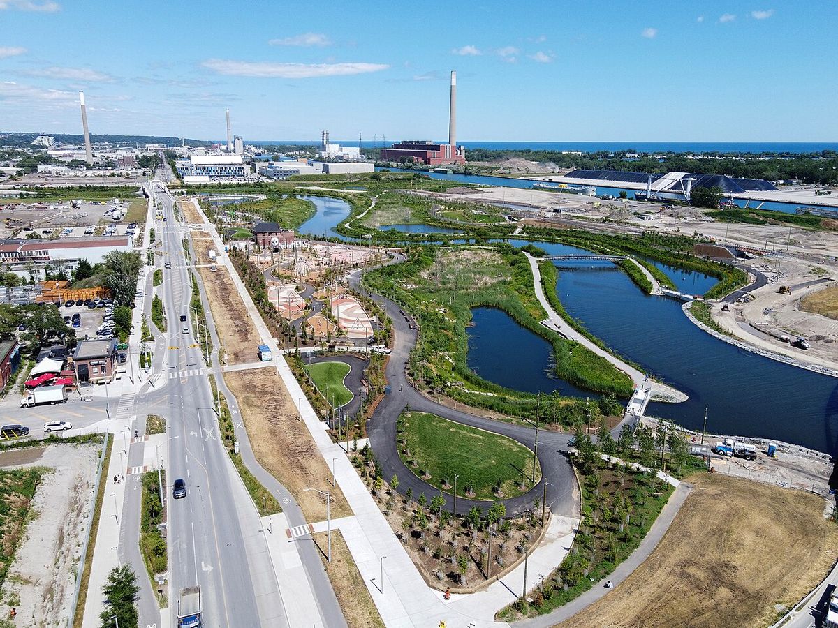
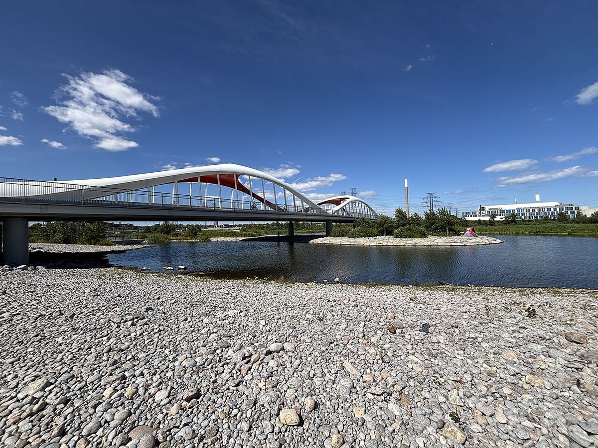
The central element of the Port Lands' transformation is the Port Lands Flood Protection Project, also known as Don Mouth Naturalization. The primary problem was the Don River's 90-degree turn into the concrete-lined Keating Channel, a bottleneck that created significant flooding risks for the area and prevented safe development. In 2017, Waterfront Toronto received $1.25 billion from three levels of government to address this by creating a new, naturalized river mouth. The project involved excavating a new one-kilometre river channel running south from the Don River, then west between Commissioners Street and the Shipping Channel to provide a second outlet into the inner harbour. This engineering work created a 39.6-hectare island named Ookwemin Minising, bound by the Keating Channel to the north, the new river to the east and south, and the inner harbour to the west.
The Port Lands Flood Protection Project involved building reinforced riverbanks, wetlands, and the only natural shoreline in Toronto's Inner Harbour to support aquatic habitat. Lakefilling work around Essroc Quay was completed in March 2020 to help form the northwest corner of the new island and realign Cherry Street. The core flood protection work was completed in the mid 2020s, unlocking the area for extensive development. This development is supported by an additional $975 million in tri government funding announced in 2025 specifically for housing on Ookwemin Minising and the Quayside area.
New Neighbourhoods and Parks
The revitalization plan envisions at least four new mixed-use neighbourhoods across the Port Lands, with a focus on creating complete, sustainable communities. The first and most advanced is Ookwemin Minising, an island community whose name means place of the black cherry trees in Anishinaabemowin. An updated precinct plan for the island, providing for greater densities and an inclusive, walkable community, was adopted by Toronto City Council on May 21, 2026. The island is planned to eventually be home to more than 15,000 people, with the first residents expected to move in by 2031. Another planned district is the McCleary District, a 50-acre parcel envisioned as a dense, transit-oriented mixed-use hub.
The plan creates 80 acres of new parkland and greenspace, centred on Biidaasige Park, meaning sunlight shining towards us. This park system runs along the new river valley on Ookwemin Minising and opened in two phases, with the first 50 acres opening in July 2025 and the remaining 10 acres scheduled to open in 2026. The park design includes spaces for activities and relaxation, with river access and diverse ecological features. Other existing and new recreational areas include Cherry Beach, the Martin Goodman Trail, the Leslie Street Spit bird sanctuary, and Leslie Lookout Park, which opened in 2024 with a public beach and viewing platform.
Current Industry, Port Functions and Transportation
While undergoing transformation, the Port Lands remain an active industrial and port district. The Port of Toronto, operated by PortsToronto, is a 21-hectare container shipping facility and cruise ship terminal on the inner harbour. PortsToronto also operates the large Outer Harbour Marina between Cherry and Leslie Streets. The area is the single largest provider of concrete for downtown Toronto, with a concrete campus at 575 Commissioners Street consolidating operations for several companies. The Toronto Port Lands Company, a City corporation managing 160 hectares, is the largest landlord with over 80 tenants as of 2015.
Key industrial and municipal facilities include the Portlands Energy Centre cogeneration plant, the Ashbridges Bay Wastewater Treatment Plant, and Toronto Hydro's facility at 500 Commissioners Street. The district is a major hub for film and television production, anchored by Pinewood Toronto Studios, built on a former oil tank farm. In 2025 alone, the City issued 95 film permits for the Port Lands. Transportation infrastructure includes the now out-of-service Hearn Generating Station, the TTC's Leslie Barns streetcar facility and Lakeshore garage, and a largely disused railway loop owned by the Toronto Port Lands Company.
- Port of Toronto: 21-hectare container and cruise terminal.
- Concrete Campus: Consolidates Essroc, Lafarge, Metrix, St. Mary's.
- Pinewood Toronto Studios: Major film production hub.
- Portlands Energy Centre: Cogeneration power plant.
- Ashbridges Bay Wastewater Treatment Plant: Major sewage facility.
- Leslie Barns: TTC streetcar maintenance and storage facility.
Geography and Major Streets
The Port Lands district is defined by its waterfront location and major transportation corridors. It is bounded by Lake Shore Boulevard to the north, Leslie Street to the east, the Inner Harbour to the west, and Lake Ontario to the south. The area's street grid reflects its industrial history and new planning. Cherry Street is the primary north-south artery on the west side, providing access from Lake Shore Boulevard south to Cherry Beach and the new island communities. Commissioners Street, named for the Toronto Harbour Commission, runs east-west as the spine north of the Ship Channel, while Unwin Avenue serves a similar function to the south between the channel and the lake, leading to the Outer Harbour Marina.
The Don Roadway connects the south end of the Don Valley Parkway into the area. Other notable streets include Carlaw and Logan Avenues, which cross from north of Lake Shore into the district, and a series of minor streets in the northern section such as Bouchette, Saulter Street South, and Polson Street. Regatta Road, south of Unwin Avenue, is home to several sailing and rowing clubs along the Martin Goodman Trail. The geography has been fundamentally altered by the new river channel, which now defines the eastern and southern edges of Ookwemin Minising, separating it from the mainland Port Lands.
Arts, Culture and Recreation
The Port Lands host a distinctive mix of cultural and recreational uses alongside its industrial base. Vacated industrial spaces have been repurposed by a cultural contingent, including musician jam spaces, recording studios, and artist collectives. The old box factory on Polson Pier houses artist Max Dean's studio and the VSVSVS collective gallery. The Rebel nightclub is located on Polson Street, and Cirque du Soleil presented touring shows under its Grand Chapiteau on vacant land at Cherry and Commissioners Streets between 2007 and 2017. The area's raw, post-industrial aesthetic continues to attract creative projects and events.
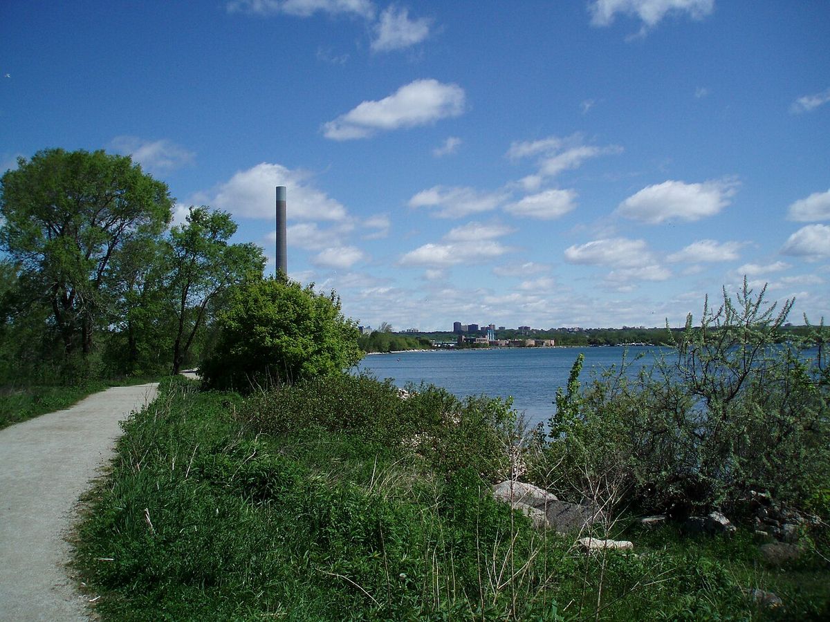
Recreation is centred on the waterfront. The Leslie Street Spit, a human-made peninsula extending south, forms the Outer Harbour and contains a significant bird sanctuary. Cherry Beach at the southwest corner is a popular public beach and sports field destination. The Martin Goodman Trail runs through the area, providing continuous waterfront cycling and walking access. A cluster of sailing clubs is located along Regatta Road, including the Hanlan Boat Club, Mooredale Sailing Club, and the Toronto Multihull Sailing Club. These existing amenities are being significantly expanded with the new Biidaasige Park and the network of parks and trails within the naturalized river valley.
- Leslie Street Spit: Human-made peninsula forming Outer Harbour and bird sanctuary.
- Cherry Beach: Public beach and sports fields in southwest corner.
- Martin Goodman Trail: Major waterfront cycling and walking path.
- Sailing Clubs: Include Hanlan, Mooredale, St. James Town, West Wood, Sailing Fanatics, Toronto Multihull.
- Artist Spaces: Max Dean studio, VSVSVS collective at Polson Pier.
- Rebel Nightclub: Entertainment venue on Polson Street.
Governance and Planning Framework
The revitalization of the Port Lands is governed by a complex partnership between multiple public agencies. Waterfront Toronto, a tri-government corporation established in 2001, is the lead planning and project delivery agency for the flood protection and enabling infrastructure. The City of Toronto's interests are managed through CreateTO, which oversees the Toronto Port Lands Company, the largest landowner in the area. The Port Lands Planning Framework, approved by City Council in 2017 and by the Ontario Land Tribunal in 2022, provides the 50-year vision for transforming the district into new, mixed-use neighbourhoods with unique local identities that promote social interaction and a prosperous economy.
This framework is implemented through the Port Lands Area Specific Policy, part of the Central Waterfront Secondary Plan. Precinct planning for specific areas, such as Ookwemin Minising, advances this vision with detailed zoning and design guidelines. The updated Precinct Plan for Ookwemin Minising, approved by Council in June 2024 and again in May 2026, increased densities to respond to Toronto's housing needs. Ongoing public engagement is a key component, with events like the Port Lands Open House: From Plan to Place held on March 10, 2026, to update the community on progress. This collaborative governance model ensures the coordinated development of infrastructure, housing, parks, and economic opportunities across the vast site.
Future Outlook and Economic Impact
The Port Lands represent one of the most significant urban development opportunities in Canada, poised to deliver substantial economic, social, and environmental benefits for Toronto. The planned minimum of 40,000 residents and 20,000 jobs will contribute significantly to the city's tax base and labour market. The district is designed to support a diverse economy, retaining and enhancing its role in port operations, concrete supply, and particularly the film industry, while adding new commercial, retail, and innovation sectors. The commitment to including affordable housing within new neighbourhoods is a central part of the social equity goals for the development.
The environmental restoration turned a hardened industrial landscape back into a naturalized river mouth with wetlands and habitat, improving water quality and resilience to climate change. The project created 80 acres of new parkland, including Biidaasige Park which opened in July 2025. This parkland provides major new public destinations and recreational space for the entire city. As infrastructure work continues and development parcels are brought to market, the Port Lands will gradually evolve from a largely industrial zone into a series of complete, connected waterfront communities. This process will fundamentally reshape Toronto's eastern waterfront over the coming decades.
Questions about Port Lands
What is the Port Lands Flood Protection Project?
The Port Lands Flood Protection Project is also known as the Don Mouth Naturalization. It is a major initiative to protect the Port Lands from flooding and enable development. The project addressed the flooding risk caused by the Don River's 90 degree turn into the Keating Channel. It created a new channel running south from the Don River and then west to provide a second outlet. Completed in the mid 2020s, the project created the island Ookwemin Minising and involved building wetlands and reinforced riverbanks.
What is Ookwemin Minising?
Ookwemin Minising is a 39.6-hectare island created by the Port Lands Flood Protection Project. Its name means place of the black cherry trees in Anishinaabemowin. The island is bounded by the Keating Channel to the north, the new Don River channel to the east and south, and the inner harbour to the west. It is planned as a sustainable, inclusive waterfront community that will eventually be home to more than 15,000 people, featuring parks, public spaces, and housing, including affordable units. The first phase of housing is expected to welcome residents by 2031.
What is Biidaasige Park?
Biidaasige Park is a major new public park on Ookwemin Minising, with a name meaning sunlight shining towards us. It is an 80-acre park system that runs along the new naturalized Don River channel, providing greenspace, river access, and areas for both activity and relaxation. The park opened in two phases, with the first 50 acres opening in July 2025 and the remaining 10 acres scheduled to open in 2026. It is a central recreational destination within the revitalized Port Lands.
What major industries are currently in the Port Lands?
The Port Lands remain an active industrial and port district. Key industries include the Port of Toronto, a container and cruise ship terminal. A major concrete production campus serving downtown Toronto. And the Ashbridges Bay Wastewater Treatment Plant. The area is also a hub for film and television production, anchored by Pinewood Toronto Studios. In 2025, 36 unique productions filmed at the district's studios. Other uses include energy generation, salt storage, and various light industrial tenants.
Where are the Port Lands located in Toronto?
The Port Lands are located approximately five kilometres southeast of downtown Toronto, on the former Don River delta and most of Ashbridge's Bay. The area's approximate geographical borders are the Gardiner Expressway and Don Valley Parkway ramps to the north and west, Lake Shore Boulevard to the north, and Lake Ontario on the remaining sides. This industrial and recreational neighbourhood covers about 356 hectares or 880 acres of city owned land. It stretches from the Inner Harbour in the west to Leslie Street in the east, and from Lake Shore Boulevard East in the north to the Outer Harbour in the south. The area was created in the early 20th century by filling in Ashbridge's Bay to create industrial land.
How many people will eventually live in the Port Lands?
The plan for the Port Lands makes room for a minimum of 40,000 people across four mixed use neighbourhoods. This long term vision is set out in the Port Lands Planning Framework and implementing policies. The plan also aims to create at least 20,000 jobs in a diverse range of industries from film production to cargo handling. Significant tri government investment has been committed to unlock this development, including a recent $975 million commitment in 2025 for housing on Ookwemin Minising. The first development phase on Ookwemin Minising expects people to move into new housing by 2031.
Sources and further reading
- Port Lands (Wikipedia)
- Port Lands, City of Toronto (toronto.ca)
- What are we building, Waterfront Toronto (portlandsto.ca)
- Port Lands (createto.ca)
- Port Lands Open House: From Plan to Place, March 10, ... (waterfrontoronto.ca)
Checked by the Your Space Hamilton desk. Last updated 2026-10-28.