Hurricane Edna
Hurricane Edna was a powerful and deadly major hurricane that struck the eastern United States and Atlantic Canada in September 1954. As the second hurricane to hit Massachusetts within 11 days, following Hurricane Carol, Edna compounded damage and tested the resilience of New England communities. The storm caused 29 fatalities and significant property and agricultural damage, becoming the costliest hurricane in Maine's history at the time. Its extratropical remnants brought destructive winds and severe crop losses to Nova Scotia and New Brunswick, marking a significant weather event for eastern Canada.
Meteorological development and track
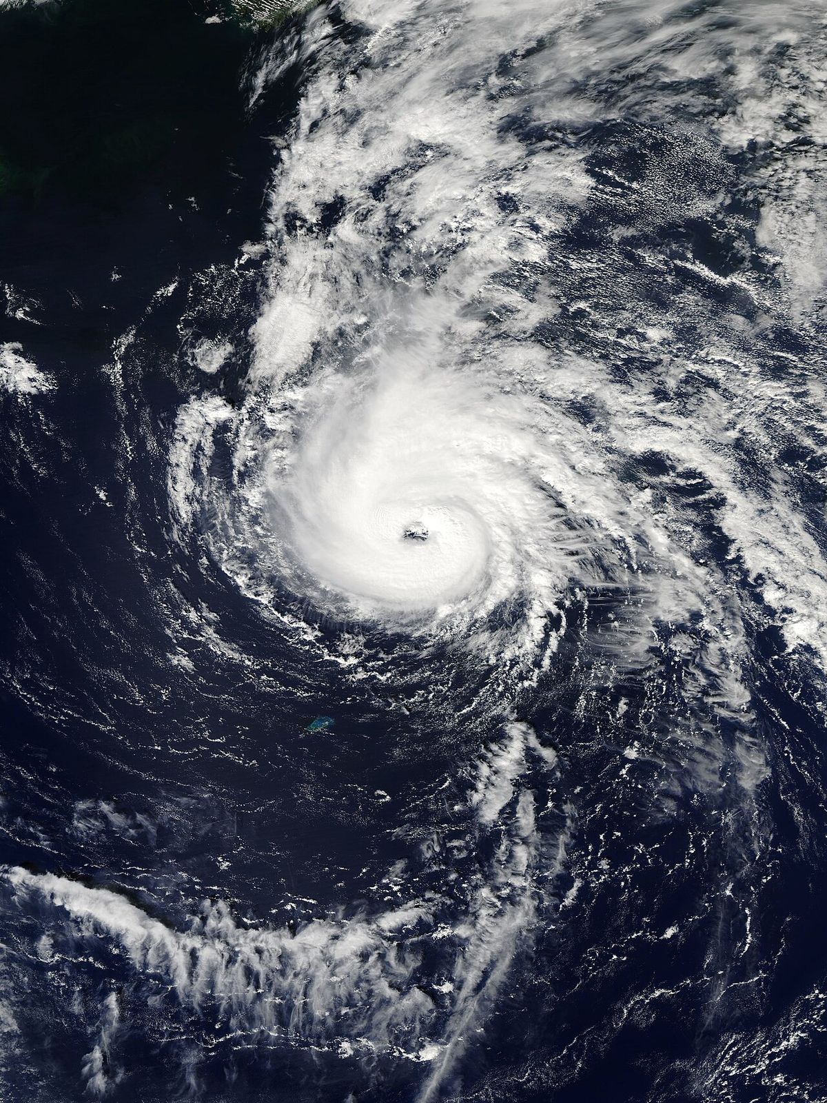
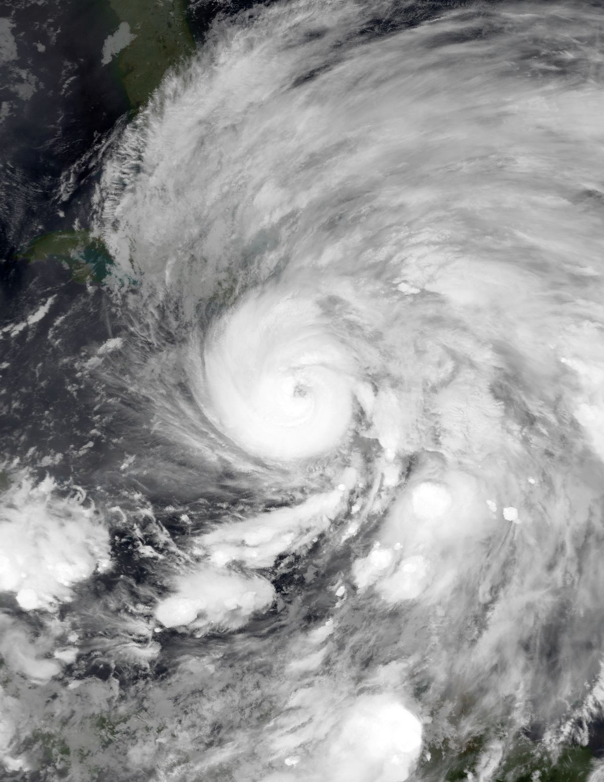
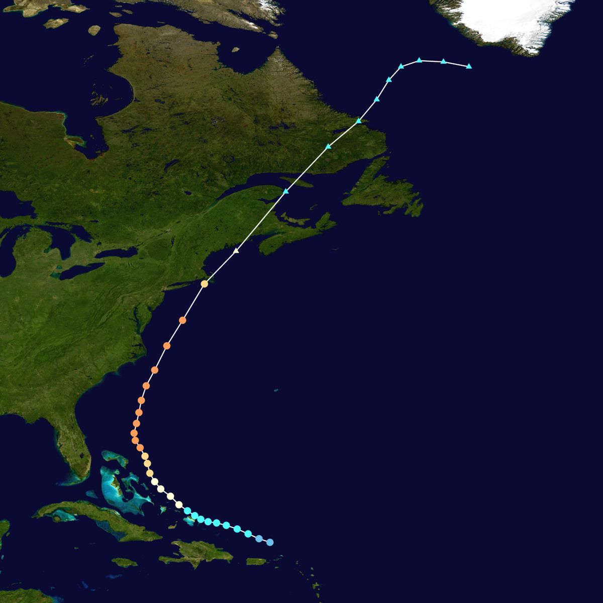
Hurricane Edna originated from a tropical wave east of the Caribbean Sea, with the Atlantic hurricane database indicating it achieved tropical storm status early on September 4, 1954. The system moved west-northwest, bypassing Hispaniola to the north, and strengthened into a minimal hurricane by September 7. It rapidly intensified into a Category 3 major hurricane on September 8 while broadly curving northward near San Salvador Island in the Bahamas. Reconnaissance aircraft reported a maturing eye approximately 20 miles in diameter as the storm's circulation expanded. Edna maintained peak winds of 120 mph for over two days while tracking nearly due north, with its central pressure falling to 968 mbar on September 9. The hurricane accelerated northeastward, passing east of the Outer Banks of North Carolina on September 10 and 11. It closely followed the recent path of Hurricane Carol but diverged by skirting the eastern New England coast instead of moving inland. Edna passed directly over Cape Cod, Massachusetts, on September 11 after weakening to Category 2 strength, with a central pressure of 950 mbar. The storm then tracked just east of Eastport, Maine, before transitioning into an extratropical cyclone over Atlantic Canada. Its remnants were last noted over the northern Atlantic on September 15. The storm's track was difficult to pinpoint due to inconsistent and inaccurate reconnaissance data at times, attributed to misinterpretation of radar information.
Preparations and warnings
Extensive warnings and preparations preceded Hurricane Edna's arrival along the densely populated U.S. Northeast coast. Hurricane warnings were initially issued for parts of the Bahamas and South Florida, with storm warnings later posted from Myrtle Beach, South Carolina, to Eastport, Maine. The New York Weather Bureau predicted Edna could be one of the most severe hurricanes in its history, leading to a surge in telephone calls. In the 24 hours before landfall, New York Telephone handled 361,392 calls, the third highest volume the company had ever recorded. Evacuations were widespread, particularly in areas recently hit by Hurricane Carol. In Montauk, New York, 500 residents evacuated their homes, while 3,000 families left Milford, Connecticut. Sirens alerted residents to stay indoors, and bus and train services were halted along the Connecticut coast. The U.S. Navy ordered the evacuation of hundreds of warships and aircraft, and Coast Guard planes relocated from Rhode Island and Massachusetts. About 40 Red Cross shelters that had opened for Carol were reopened, and Fort Devens sent 40 trucks with cots, blankets, and generators to expected impact zones. Officials credited the advance warnings with helping to reduce the death toll compared to the earlier hurricane. The scale of preparation is illustrated by key actions taken in New England.
- All businesses closed in Westerly, Rhode Island, on September 11.
- Providence, Rhode Island, businesses prepared sandbags to mitigate flooding after being flooded during Carol.
- A state of emergency was declared in New London, Connecticut.
- Mail service was canceled in some threatened areas.
- Most beach homes had already closed for the summer season, reducing the population at risk.
- Hundreds of people evacuated from the southern New England coastline.
The widespread evacuations in southern New England occurred after Hurricane Carol had struck the same area only 11 days prior. Advance warning for Hurricane Edna was credited with resulting in a lower death toll than from Hurricane Carol. About 40 Red Cross shelters that were opened during Hurricane Carol were reopened to provide food. The preparations reflected a heightened state of alert following the recent disaster.
Impact on the United States
Hurricane Edna's impacts ranged from flooding in the Caribbean to destructive winds and storm surge in New England. In Puerto Rico, the storm dropped over 10 inches of rain in two days, causing extensive flooding along the island's western and southern coasts. The eastern Bahamas, including San Salvador, experienced gale force winds and high seas. Along the U.S. East Coast, the storm brushed North Carolina about 50 miles east of where Carol had passed, producing 70 mph winds and strong surf but no major damage or fatalities. Tides at Norfolk, Virginia, were only slightly above normal, and winds in Maryland and Delaware were moderate, with rainfall there easing drought conditions. In coastal New Jersey, northwesterly winds reached 65 mph and Long Branch received about 4 inches of rain. In New York City, the hurricane delivered 4.98 inches of rain on September 11, marking the wettest day there in 45 years. A Weather Bureau station in the city recorded 45 mph winds at midday. The storm cut off Montauk Point on Long Island, prompting the Coast Guard to temporarily relocate 500 families. Rainfall in Suffolk County amounted to 9 inches. Crop damage in New York State was estimated at $1.5 million, and six highway deaths occurred in the state. The core of the hurricane struck New England with a forward speed of 45 mph, making landfall in eastern Massachusetts about 100 miles east of Carol's point of impact.
Wind gusts reached 120 mph on Martha's Vineyard, 110 mph on Block Island, and 100 mph at Hyannis, Massachusetts. The high winds caused extensive power outages for 260,000 people across New England, including nearly all of Cape Cod. A storm surge of up to 6 feet caused coastal flooding and heavy boating damage in Massachusetts. Further west, lesser coastal flooding occurred, but heavy rainfall after previously wet conditions caused urban and stream flooding. Rainfall peaked at around 11 inches in the region. Damage in Connecticut and Rhode Island was mainly in areas already affected by Hurricane Carol, with several streets washed out and rivers rising above flood stage. Damage was most severe in Maine, where Edna became the state's costliest hurricane with an estimated $25 million in losses. Wind gusts reached 74 mph and rainfall peaked at 7.49 inches, the heaviest in the state in 58 years. The Kennebec River at Augusta rose to 20.5 feet, which was 5 feet above the peak level after the spring snow melt, and the Androscoggin River also reached above normal levels. Flooding entered basements, affected fields, covered bridges, and washed out a bridge under construction in West Peru. Downed trees blocked widespread roads and caused power outages for 18 percent of Maine's population. Washed out roads and rail lines temporarily cut off the state from the rest of New England. There were eight deaths in the state, most from cars being swept away by floodwaters, including a rescue incident in Unity where one child and a rescuer were killed. Total U.S. damage was estimated at $42,815,000, with 21 fatalities in New England.
Impact on Atlantic Canada
As an extratropical cyclone, Edna brought widespread destruction to Atlantic Canada, particularly in Nova Scotia and New Brunswick. The storm was notably larger than Hurricane Juan of 2003, with strong winds extending hundreds of kilometres from its centre. The tightest pressure gradient was focused over mainland Nova Scotia, where sustained winds reached 160 km/h at Yarmouth and 95 km/h at Halifax. The intense winds downed approximately 700 million board feet of timber across the region, an amount comparable to Juan but over a more widespread area. The winds caused extensive damage to infrastructure and property. Power and telephone lines were downed, and many barns were destroyed, resulting in the loss of livestock. One man was killed by a collapsing structure. Property damage included several fallen chimneys, a toppled church steeple in Pictou, and roof failures. In Kentville, an under construction apartment building was destroyed. The storm caused severe agricultural losses, decimating an estimated $3 million CAD worth of apple crops. In Yarmouth, both live lobsters and lobster pots were lost to the storm. Debris blocked streets across the province, and at least 800 metres of road was washed out. Total damage in Nova Scotia reached $6 million CAD, prompting states of emergency in Yarmouth and Kentville.
In New Brunswick, the storm produced 130 mm of rain and winds of 120 km/h. Wind damage was less severe than in Nova Scotia but still evident in damaged structures and utility lines. A theatre in McAdam was destroyed, and several people were injured across the area. Streets flooded in St. Stephen, and about 400 salmon valued at $10,000 CAD were lost in Dalhousie. Total damage in New Brunswick was estimated at $1.78 million CAD. Power outages were also reported as far west as Montreal, Quebec. The storm's passage highlighted the vulnerability of the Maritimes to late-season tropical transitions. The specific impacts across the Maritimes included several notable events.
- Yarmouth, Nova Scotia, recorded sustained winds of 160 km/h (99 mph).
- An estimated $3 million CAD in apple crops were destroyed in Nova Scotia.
- A church steeple toppled in Pictou, Nova Scotia.
- Kentville, Nova Scotia, declared a state of emergency after the storm.
- A theatre was destroyed in McAdam, New Brunswick.
- Approximately 400 salmon were lost in Dalhousie, New Brunswick.
- Streets were flooded in St. Stephen, New Brunswick.
- Power outages occurred in Montreal, Quebec.
Aftermath and recovery
The immediate aftermath of Hurricane Edna saw a significant coordinated recovery effort across the affected regions. In New England, 20 counties were declared states of emergency. Southern New England Telephone dispatched a crew of 100 workers in 50 trucks to Maine to assist in restoring power, which was accomplished relatively quickly and was in some places less severe than during Carol. Most primary roads reopened within two days, although rural areas and rail lines required longer repairs. A temporary travel ban for all but emergency vehicles was enacted in Maine due to washed out roads. For only the third time in its history, the Portland Evening Express was not delivered due to the storm's disruption. The storm struck on the eve of the Maine gubernatorial election between Republican Burton M. Cross and Democrat Edmund Muskie. Politicians noted that a suppressed voter turnout due to the storm would benefit Muskie, as rural Republican areas were harder hit. Muskie ultimately won the close election, with turnout lower than in 1950, partly attributed to Edna's disruption. Following a survey by the Federal Civil Defense Administration that described damage as tremendous, President Dwight Eisenhower declared portions of Maine a disaster area, unlocking federal funding for relief. The president also authorized additional aid for Rhode Island and Massachusetts due to damage from Edna. The storm's severity led to the retirement of the name Edna from the Atlantic tropical storm naming list for a decade.
Retirement, naming history, and cultural reference
The name Edna was permanently retired from the Atlantic tropical cyclone naming list due to the hurricane's significant impact. It was removed from use for ten years following the 1954 season. The name was briefly reused in the 1968 season but was permanently retired in the spring of 1969, as the 1954 hurricane remained an active subject of meteorological research. The name appeared once more on a preliminary list for the 1972 season but ultimately went unused and will never be used again for an Atlantic hurricane. In popular culture, the storm was the subject of a 1954 essay by E.B. White published in The New Yorker titled The Eye of Edna. The piece was a witty satire that gently mocked radio announcers who seemed to relish the hurricane and made exaggerated predictions about its speed and strength. This literary reference shows the storm's prominence in the public consciousness during that active hurricane season. The history of the name's use and retirement follows a clear timeline.
- 1954: Hurricane Edna causes significant damage, leading to its initial retirement.
- 1968: The name Edna is temporarily reintroduced for one season.
- Spring 1969: The name is permanently retired from the Atlantic naming lists.
- 1972: The name appears on a preliminary naming list but goes unused.
- Present: The name Edna is permanently retired and will not be used for a future Atlantic hurricane.
Comparative hurricane data for the 1954 season
The 1954 Atlantic hurricane season was notably active, featuring several storms that impacted the East Coast. Hurricane Edna was one of two major hurricanes to strike Massachusetts that year, alongside Hurricane Carol. The table below outlines key details of the notable hurricanes from that season, illustrating the repeated blows dealt to the region. This series of storms, sometimes called the twisted sisters of 1954, led to major changes in disaster preparedness and forecasting. The consecutive impacts of Carol and Edna, in particular, demonstrated the vulnerability of the northeastern United States to back to back tropical systems and showed the importance of timely evacuations and warnings. The 1954 season remains a benchmark for hurricane activity in the region.
| Hurricane | Peak Category | Landfall Area | U.S. Fatalities | Notable Feature |
|---|---|---|---|---|
| Edna | Category 3 | Cape Cod, Massachusetts | 21 (New England) | Costliest hurricane in Maine history at the time |
| Hazel | Category 4 | Carolinas, Ontario | 95 | Caused significant damage in Canada |
Questions about Hurricane Edna
How many people died in Hurricane Edna?
Hurricane Edna caused 29 fatalities throughout its path as a tropical and extratropical cyclone. In the United States, there were 21 deaths in New England, with eight of those drownings occurring in Maine due to vehicles being swept away by floods. The remaining fatalities occurred elsewhere along the storm's track. In Atlantic Canada, one man was killed in Nova Scotia by a collapsing structure. The death toll was lower than that of Hurricane Carol, which struck the same region 11 days earlier, a fact credited to improved warnings and preparations.
Why is the hurricane named Edna retired?
The name Edna was permanently retired from the Atlantic tropical cyclone naming list due to the hurricane's significant death toll and destructive impacts. It was initially removed from use for ten years following the 1954 season. Although briefly reused in 1968, the name was permanently retired in the spring of 1969 because the 1954 hurricane remained an active subject of meteorological research. The name appeared on a preliminary list for 1972 but went unused and will never be used again for an Atlantic hurricane, a honour reserved for the most severe storms.
How did Hurricane Edna affect Canada?
Hurricane Edna affected Atlantic Canada as an extratropical cyclone, bringing destructive winds and heavy rain to Nova Scotia and New Brunswick. In Nova Scotia, sustained winds reached 160 km/h in Yarmouth, causing widespread power outages, destroying barns, and downing approximately 700 million board feet of timber. The storm caused an estimated $6 million CAD in damage in the province, leading to states of emergency in Yarmouth and Kentville. In New Brunswick, winds of 120 km/h and 130 mm of rain caused flooding and structural damage, with losses estimated at $1.78 million CAD. The storm also caused power outages in Montreal.
How did Edna compare to Hurricane Carol?
Hurricane Edna struck New England only 11 days after Hurricane Carol, compounding damage in the region. While both were major hurricanes, Edna's track was about 100 miles east of Carol's, skirting the coast rather than moving inland. This resulted in Edna's strongest winds not coinciding with the highest tides, which led to less storm surge damage than Carol. However, Edna caused more significant flooding in Maine due to heavy rainfall on already saturated ground. Overall, damage from Edna was less than from Carol, but the consecutive storms led to widespread evacuations and tested recovery efforts.
What were the peak wind speeds recorded during Hurricane Edna?
Hurricane Edna reached its peak intensity as a Category 3 major hurricane with maximum sustained winds of 125 mph (205 km/h) north of the Bahamas. At landfall in New England, it had weakened to Category 2 status. The highest wind gusts recorded were 120 mph on Martha's Vineyard, 110 mph on Block Island, and 100 mph at Hyannis, Massachusetts. In Atlantic Canada, sustained winds reached 160 km/h (99 mph) at Yarmouth, Nova Scotia. These winds caused extensive power outages, downed countless trees, and contributed to significant structural damage along the storm's path.
What was the damage cost of Hurricane Edna?
Total damage from Hurricane Edna in the United States was estimated at $42,815,000. The hurricane was especially destructive in Maine, where it became the costliest hurricane in the state's history with an estimated $25 million in damage. This damage included flooding that washed out roads and rail lines, extensive property damage, and significant timber loss. These figures encompassed destroyed crops, downed power lines, structural damage to buildings, and washed out roads. Overall, the damage was less than that caused by Hurricane Carol, partly because Edna's strongest winds did not coincide with the highest tides.
Sources: Wikipedia and current public reporting, checked by the Your Space Hamilton desk. Last updated 2026-10-27.