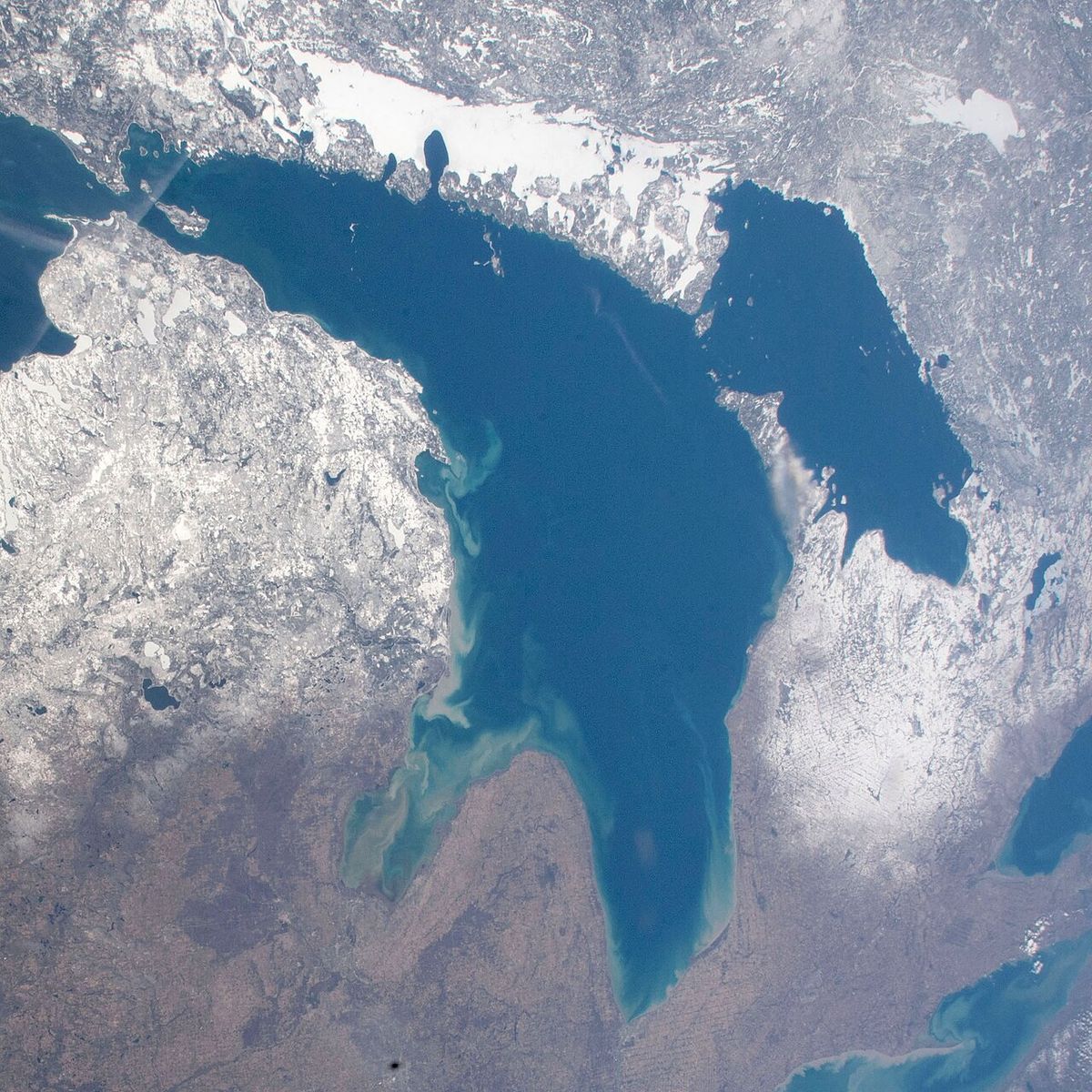
Lake Michigan-Huron
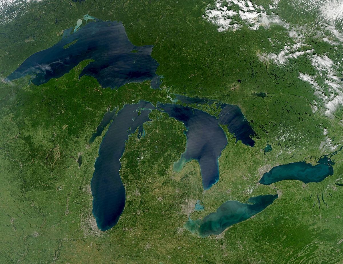
Lake Michigan-Huron is the singular body of water formed by the hydrological union of Lake Michigan and Lake Huron. These two Great Lakes are permanently connected by the 5-mile-wide, 295-foot-deep Straits of Mackinac, which allows water to flow freely between them, equalizing their surface levels. When considered as one entity, Lake Michigan-Huron becomes the largest freshwater lake in the world by surface area, a fact of significant geographical and environmental importance to Canada and the United States. Its complex hydrology and geologic history are central to understanding the Great Lakes ecosystem, which contains a substantial portion of the world's surface freshwater and is vital to the economies and communities of both nations.
Geologic History and Formation
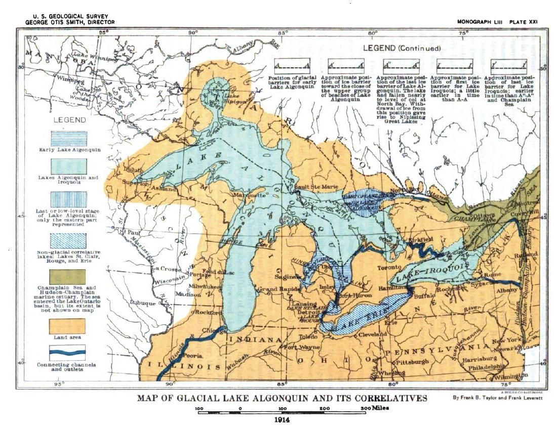
The modern configuration of Lake Michigan-Huron is the result of dramatic geologic changes spanning thousands of years, driven primarily by the advance and retreat of continental ice sheets. During the last ice age, the basins that now hold Lakes Michigan, Huron, and Superior experienced repeated flooding and separation as glacial ice dammed and released meltwater. Around 9,000 years BC, following the retreat of the Laurentian ice sheet, a massive prehistoric lake known as Lake Algonquin occupied the basins of modern Lakes Huron, Michigan, and much of Superior. This lake drained southward into the Mississippi River watershed, reflecting the vastly different drainage patterns of the past. Earlier still, the southern end of the Michigan basin was occupied by Lake Chicago, which was also dammed by glacial ice and drained south.
Approximately 9,500 years ago, new eastern drainage pathways opened as the ice retreated further, leading to the separation of proglacial Lake Stanley, the precursor to Lake Huron, from proglacial Lake Chippewa, the precursor to Lake Michigan. These two lakes were connected by the now-submerged Mackinac Channel, with Lake Chippewa discharging into Lake Stanley over a feature known as Mackinac Falls. The ongoing warping of the Earth's crust, known as post-glacial rebound, continued to alter the landscape, eventually allowing the reunification of the Superior, Michigan, and Huron basins into a single lake system called the Nipissing Great Lakes. This stable configuration lasted for over a millennium until other lake outlets were cut off around 4,000 years ago, steering the drainage primarily through the St. Clair River and solidifying the lake's contemporary evolution.
Bathymetry and Hydrological Connection
The physical link between Lake Michigan and Lake Huron is the Straits of Mackinac, a 5-mile-wide and 120-foot-deep channel that represents a significant constriction in the lake's bathymetry. Despite this bottleneck, the straits are sufficiently deep and wide to permit the unrestricted exchange of water, which is why hydrologists classify the two lakes as one. The maximum depths of the individual basins are far greater, with Lake Michigan reaching 923 feet and Lake Huron reaching 750 feet. The shared water level is a direct consequence of this connection, with both lakes maintaining an identical mean elevation, recorded at 580 feet in June 2015. The primary inflow to the entire Lake Michigan-Huron system is the St. Mary's River, which brings water from Lake Superior, while the main outflow is the St. Clair River, which carries water toward Lake Erie and eventually to the Atlantic Ocean.
Water movement through the Straits of Mackinac is dynamic and influenced by complex environmental factors. While the long-term average flow is eastward from Lake Michigan to Lake Huron at a rate of 1,500 to 2,000 cubic metres per second, the direction can reverse temporarily. Seiches, which are standing waves in an enclosed body of water, and differing weather conditions such as atmospheric pressure and wind over each basin can drive substantial volumes of water in either direction. These flows can sometimes exceed 75,000 cubic metres per second for several hours, demonstrating the powerful hydraulic connection. The inflow from Lake Superior is managed through the cooperative efforts of the bi-national Lake Superior Board of Control, which operates locks and canals to regulate water levels throughout the Great Lakes system.
Global and Regional Significance
When treated as separate entities, Lake Michigan and Lake Huron are traditionally counted among the world's largest lakes, with Lake Superior retaining the title of the largest Great Lake by volume. However, the hydrological reality of their permanent connection through the Straits of Mackinac necessitates a combined assessment in many scientific and resource management contexts. As a single lake, Lake Michigan-Huron surpasses Lake Superior in surface area, claiming the title of the largest freshwater lake by area on Earth. The management of this shared resource is a fundamental aspect of Canada-United States relations, governed by treaties and joint commissions.
The combined lake plays a critical role in regional climate, transportation, industry, and recreation. Its vast surface area moderates local temperatures, influences precipitation patterns, and supports a multi-billion-dollar shipping industry that moves iron ore, grain, and other bulk commodities. Major urban centres like Chicago, Milwaukee, and Toronto rely on the lake for water supply, while countless communities along its shores depend on it for tourism and fishing. Environmental challenges such as invasive species, pollution, and fluctuating water levels are managed through binational cooperation, which reflects the lake's status as a shared continental treasure. The following list outlines key characteristics that define Lake Michigan-Huron's global standing:
- Largest freshwater lake by surface area when combined.
- Contains two major basins connected by the Straits of Mackinac.
- Shared mean water level maintained by free hydraulic connection.
- Primary drainage outflow is via the St. Clair River to Lake Erie.
- Inflow regulated from Lake Superior by bi-national control board.
- Subject to significant water flow reversals due to seiches and weather.
- Geologic history includes prehistoric stages like Lake Algonquin.
Hydrological Dynamics and Flow Patterns
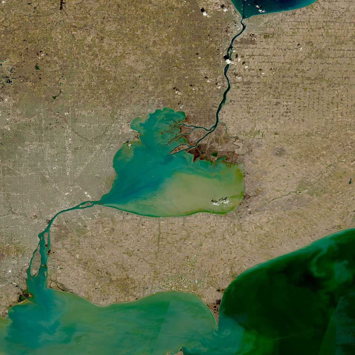
The water levels and flow patterns within Lake Michigan-Huron are governed by a balance of inflows, outflows, and atmospheric conditions. The largest single source of water is the St. Mary's River, which channels the outflow from Lake Superior into the northern part of Lake Huron. From there, water can move westward through the Straits of Mackinac into Lake Michigan or proceed directly toward the system's primary outlet, the St. Clair River. The net long-term flow through the straits is consistently eastward, reflecting the overall gravitational pull of water seeking the lowest outlet to the sea via the St. Clair and Detroit Rivers. This average flow of 1,500 to 2,000 cubic metres per second is a fundamental characteristic of the lake's hydrology.
Superimposed on this average flow are significant short-term fluctuations and even reversals. These are primarily driven by seiches, which are oscillations of the water surface caused by wind or atmospheric pressure changes, and by persistent wind setup that can temporarily pile water up in one basin. When a strong westerly wind blows across Lake Michigan, for instance, it can push surface water eastward, raising levels at the eastern end of the lake and increasing flow through the straits. Conversely, a strong easterly wind can push Huron water westward, slowing or reversing the flow. These phenomena mean that the straits function as a two-way hydraulic conduit, with instantaneous flows sometimes dwarfing the long-term average by more than thirty times. The table below summarizes key flow characteristics and dimensions of the Lake Michigan-Huron system.
| Feature | Measurement | Notes |
|---|---|---|
| Straits of Mackinac Width | 5 miles (8.0 km) | Primary connecting channel |
| Straits of Mackinac Depth | 120 ft (37 m) | Depth at the constriction |
| Long-term Avg. Flow Direction | Eastward | From Michigan to Huron |
| Long-term Avg. Flow Rate | 1,500-2,000 m³/s | Towards St. Clair River outlet |
| Peak Reversible Flow | >75,000 m³/s | Can last several hours |
| Maximum Lake Depth (Michigan) | 923 ft (281 m) | In the Chippewa Basin |
| Maximum Lake Depth (Huron) | 750 ft (229 m) | South of Manitoulin Island |
Naming Conventions and Historical Context
Despite their hydrological unity, Lake Michigan and Lake Huron are most commonly referenced as separate lakes in everyday language, official mapping, and many statistical compilations. This convention stems from historical exploration and settlement patterns, where the two basins were encountered as distinct bodies of water separated by the visible land bridge of the Straits of Mackinac region. In lists ranking the world's largest lakes by area or volume, they are typically entered individually, which places Lake Superior as the largest Great Lake and one of the largest in the world. The legal and political frameworks governing the lakes, including international boundaries and state or provincial jurisdictions, also treat them as separate entities, with the border between Canada and the United States running through Lake Huron but not Lake Michigan.
Geologists and hydrologists refer to the single lake when discussing water balance, lake level management, and geologic history, as the two basins respond as one unit to changes in inflow, evaporation, and precipitation. The name "Lake Michigan-Huron" or "Huron-Michigan" is used in these technical contexts to acknowledge this reality. This dual identity, two named lakes in culture and law versus one lake in physical science, illustrates the fascinating interplay between human perception and natural systems. The shared management of water levels, a critical issue for shoreline communities and ecosystems, requires this integrated scientific understanding to effectively address challenges posed by climate variability and human use.
Ecological and Economic Importance
The Lake Michigan-Huron system supports a diverse and valuable ecosystem that is integral to the environmental health and economic prosperity of the Great Lakes region. Its waters host numerous fish species, including lake trout, walleye, and yellow perch, which sustain commercial and recreational fisheries. The lake's extensive coastal wetlands, dunes, and islands provide critical habitat for migratory birds and other wildlife. As a shared resource between Canada and the United States, the lake's water quality and ecosystem health are managed through cooperative agreements like the Great Lakes Water Quality Agreement, which aims to address threats from pollution, nutrient runoff, and habitat loss. Invasive species, such as zebra and quagga mussels, have significantly altered the lake's food web, demonstrating the vulnerability of this large system to external pressures.
Economically, Lake Michigan-Huron is a powerhouse for both nations. It forms a key link in the Great Lakes-St. Lawrence Seaway, a vital marine highway for transporting bulk commodities like iron ore, coal, limestone, and grain between industrial heartlands and global markets. Major ports on the lake include Chicago, Milwaukee, Green Bay, Goderich, and Sarnia. The lake also supplies drinking water to millions of residents in cities and towns along its shores. Tourism and recreation generate billions of dollars annually, with activities ranging from boating and fishing to beach visits and touring historic sites like Mackinac Island. The management of water levels is a constant concern, as both high and low extremes can damage infrastructure, affect shipping, and erode shorelines, highlighting the direct connection between the lake's physical hydrology and human activity.
Questions about Lake Michigan-Huron
Why are Lake Michigan and Lake Huron considered one lake?
Lake Michigan and Lake Huron are considered one hydrological body of water because they are permanently connected by the wide and deep Straits of Mackinac. This connection allows water to flow freely between them, which keeps their surface water levels equalized. In hydrology, two bodies of water that share the same surface level are treated as one. Therefore, despite having separate names and basins, they function as a single lake, known collectively as Lake Michigan-Huron.
Does water flow both ways between the lakes?
Yes, water can and does flow in both directions through the Straits of Mackinac. While the long-term average flow is eastward from Lake Michigan to Lake Huron, short-term conditions can cause reversals. Seiches, wind setup, and differences in atmospheric pressure over the two basins can push large volumes of water westward. At times, these flows can exceed 75,000 cubic metres per second in either direction for several hours.
What was the prehistoric lake that formed Lake Michigan-Huron?
The precursor to modern Lake Michigan-Huron was a massive glacial lake called Lake Algonquin, which existed around 9,000 years BC as the continental ice sheet retreated. Lake Algonquin occupied the basins of what are now Lakes Huron, Michigan, and much of Superior. It drained south into the Mississippi River watershed. Earlier stages also included Lake Chicago in the southern Michigan basin and the separate proglacial lakes Stanley and Chippewa before they reconnected.
How is the water level of Lake Michigan-Huron managed?
The water level of Lake Michigan-Huron is a natural system influenced by precipitation, evaporation, and inflows. The primary human-controlled inflow is from Lake Superior via the St. Mary's River, which is regulated by the bi-national Lake Superior Board of Control. This board operates locks and control structures to manage outflows from Lake Superior, which in turn influences levels in Michigan-Huron. The main outflow from the system is through the St. Clair River to Lake Erie, which is a natural channel.
Is Lake Michigan-Huron the largest lake in the world?
When considered as a single hydrologic entity, Lake Michigan-Huron is the largest freshwater lake in the world by surface area. This is because Lake Michigan and Lake Huron are connected by the wide, deep Straits of Mackinac, which allows water to flow freely and keeps their water levels in equilibrium. If the two lakes are counted separately, as is the historical naming convention, then Lake Superior is larger than either individually and is considered the largest of the Great Lakes. The combined area of Michigan and Huron, however, exceeds that of Lake Superior, granting the unified body the global record for freshwater lake area.
What connects Lake Michigan and Lake Huron?
Lake Michigan and Lake Huron are physically connected by the Straits of Mackinac, an open-water passage that is 5 miles wide and 295 feet deep at its deepest point. This strait is a pronounced bottleneck in the shoreline but is deep and wide enough to allow for the substantial free exchange of water between the two lake basins. Because of this hydraulic connection through the straits, Lakes Michigan and Huron maintain the same mean water level and are considered a single lake in hydrology. The water flow through the straits is generally eastward but can move in either direction depending on local weather conditions and seiches.
Sources and further reading
- Lake Michigan-Huron (Wikipedia)
- Lake Huron (greatlakes.guide)
Checked by the Your Space Hamilton desk. Last updated 2026-10-20.