Hochelaga Archipelago
The Hochelaga Archipelago, also known as the Montreal Islands, is a group of approximately 320 islands at the confluence of the Saint Lawrence and Ottawa rivers in the southwestern part of the province of Quebec, Canada. The archipelago takes its name from Hochelaga, an Iroquoian settlement on the Island of Montreal that was later settled by the French and grew to become the modern city of Montreal. Its islands range from the densely urbanized Island of Montreal to protected natural areas like the Îles de Boucherville, which features a Québec National Park. This diverse group of islands is deeply embedded in the historical and cultural narrative of Quebec and Canada.
Geography and Hydrology
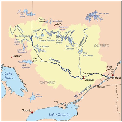
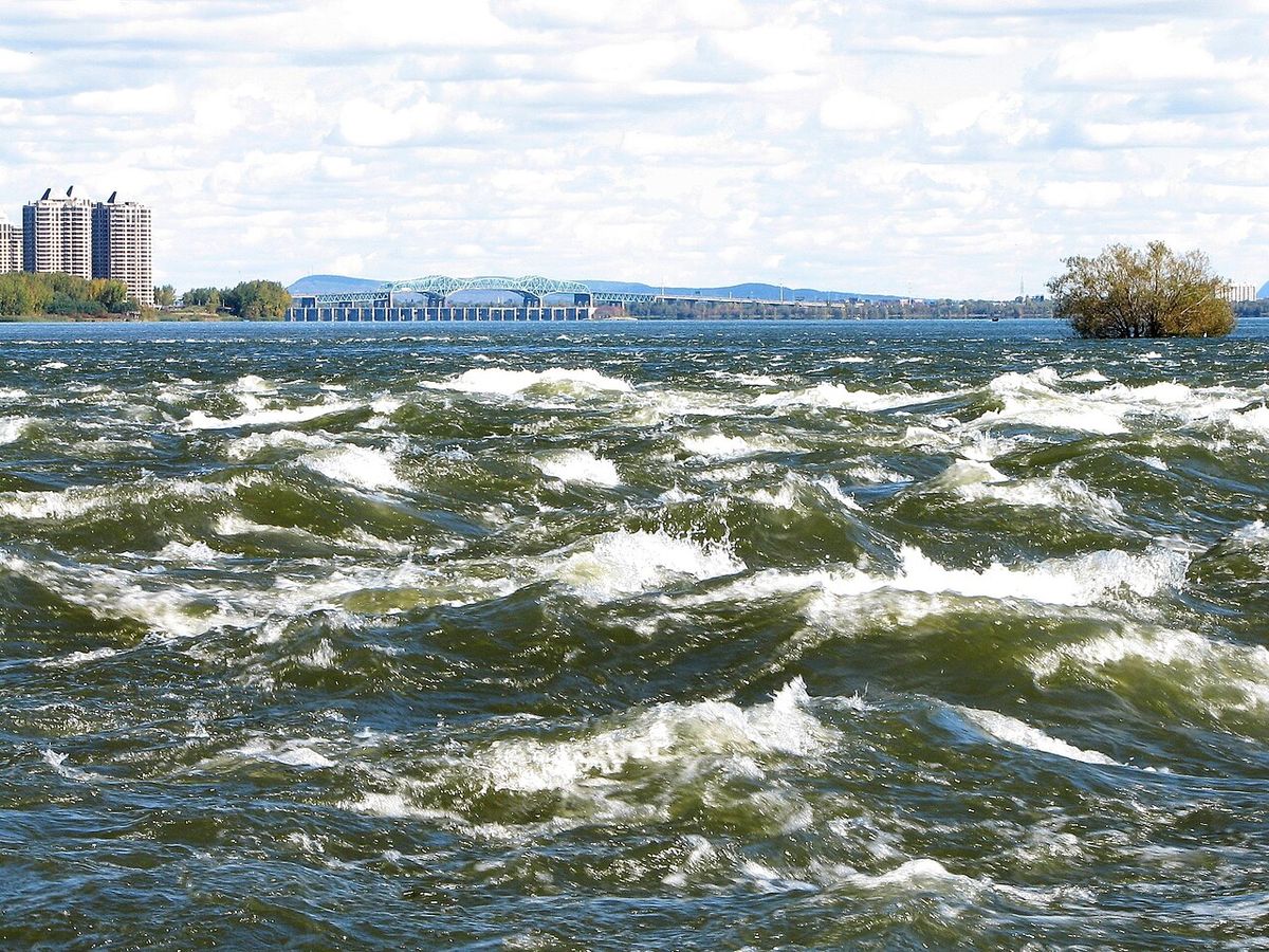
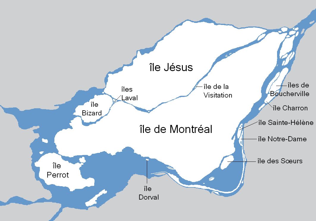
The Hochelaga Archipelago stretches from where the Ottawa River meets the Lake of Two Mountains to the islands around Île Sainte-Thérèse off the eastern tip of the Island of Montreal. The Saint Lawrence River flows along the eastern edge of the Island of Montreal, passing over narrows and rapids like the Lachine Rapids before pooling into Lac Saint-Louis. The Ottawa and Saint Lawrence rivers converge within two major lakes: Lac Saint-Louis to the southwest and the Lake of Two Mountains to the northwest. The Island of Montreal and Île Jésus are separated by the Rivière des Prairies, while Île Jésus is separated from the Quebec mainland by the Rivière des Mille Îles. These smaller rivers contain many of the archipelago's smallest islands and islets, contributing to the complex aquatic system. The archipelago's formation began roughly 11,500 years ago following the retreat of the Champlain Sea, with the major islands taking their modern forms about 8,000 years ago.
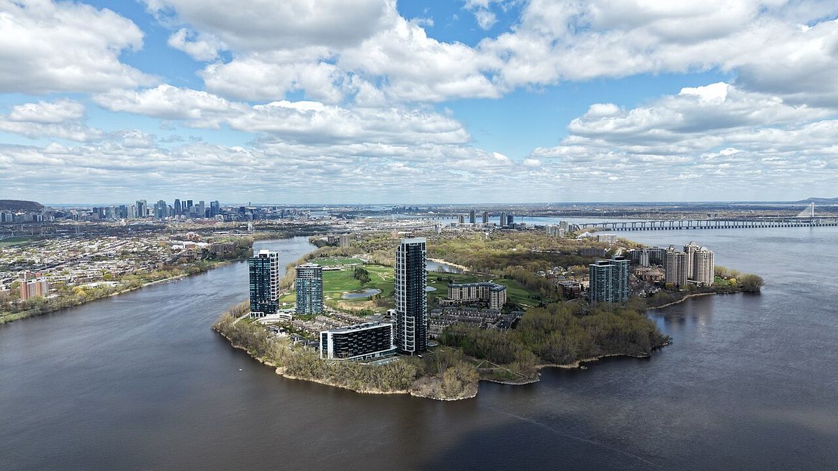
The archipelago's islands vary dramatically in size and character. The Island of Montreal, at 483 square kilometres, is not only the largest but also the most populous island in Canada. Île Jésus, at 242 square kilometres, forms the core of the city of Laval. Other principal islands include Île Perrot, Île Bizard, and the Îles de Boucherville. Many of the smaller islands, such as Dorval Island and Heron Island, are only seasonally inhabited or remain entirely wild. The islands feature fertile soil that supported Indigenous agriculture and later European settlement, with operational farms still present on several larger islands today. The archipelago also includes notable artificial islands, most famously Île Notre-Dame, which was created for Expo 67 and is now part of Parc Jean-Drapeau.
History and Indigenous Heritage
Indigenous habitation of the Hochelaga Archipelago area extends back at least 5,000 years, with evidence of St. Lawrence Iroquoian communities found across the islands. The archipelago's name derives from Hochelaga, a significant Iroquoian settlement located on the Island of Montreal. French explorer Jacques Cartier visited this village in 1535 during his voyage along the Saint Lawrence River. The word Hochelaga is a French adaptation of an Iroquoian term, believed to be either 'osekare' meaning 'beaver path' or 'osheaga' meaning 'big rapids,' the latter likely a reference to the nearby Lachine Rapids. Following European contact and colonization, the islands became central to New France and later the development of modern Montreal and its surrounding communities. The historical record of the archipelago has included islands that were once inhabited but are no longer. A notable example is Dowker Island, a roughly one square kilometre island across from Baie-D'Urfé which was granted to the governor of Montreal in the colonial period. This layered history, from ancient Indigenous settlements to contemporary metropolitan expansion, is physically embedded in the archipelago's geography, with archaeological sites existing alongside modern infrastructure.
Major Islands and Municipalities
The archipelago's islands host several major cities and are organized under multiple municipal jurisdictions. The Island of Montreal is the economic and cultural heart of the region, containing most of the city of Montreal and the central part of its metropolitan area. The City of Montreal itself has jurisdiction over 74 smaller islands within the archipelago. Key islands under Montreal's authority include Nuns' Island (Île des Sœurs), Île Bizard, Saint Helen's Island (Île Sainte-Hélène), and the artificial Île Notre-Dame. Île Jésus, the second-largest island, along with the Îles Laval and other smaller islands, constitutes the entire city of Laval, a major suburban centre north of Montreal.
Beyond these two urban cores, other significant islands support their own communities and land uses. Île Perrot is home to several municipalities, including the town of Île-Perrot and the city of Pincourt. The Îles de Boucherville are a group of islands featuring the Boucherville Islands National Park, a popular destination for outdoor recreation. Other inhabited islands include Salaberry-de-Valleyfield on Grande-Île, and Dorval Island. The distribution of population across the archipelago is heavily concentrated on the Island of Montreal and Île Jésus, while many smaller islands remain primarily natural or recreational spaces.
- Island of Montreal: 483 km², contains the city of Montreal.
- Île Jésus: 242 km², contains the city of Laval.
- Île Bizard: Part of the City of Montreal.
- Île Perrot: Contains the municipalities of Île-Perrot, Pincourt, Terrasse-Vaudreuil, and Notre-Dame-de-l'Île-Perrot.
- Îles de Boucherville: Group of islands protected as a Quebec national park.
- Saint Helen's Island and Île Notre-Dame: Part of Parc Jean-Drapeau, site of Expo 67.
- Nuns' Island (Île des Sœurs): A residential neighbourhood of Montreal.
Ecology and Conservation
The Hochelaga Archipelago contains a mosaic of natural habitats, including forests, wetlands, and riparian zones that support significant biodiversity. These ecosystems are vital for numerous bird species, fish, and other wildlife. A key species found in the archipelago's wetlands is the least bittern, the smallest heron in the Americas, which is classified as vulnerable both in Quebec and Canada. The health of these natural areas is intrinsically linked to the water quality of the Saint Lawrence and Ottawa rivers, with threats including habitat loss, pollution, and invasive species. Conservation efforts are critical to maintaining the ecological integrity of the archipelago amidst surrounding urban pressures.
For over 30 years, the Nature Conservancy of Canada (NCC) has been a leading organization in protecting the islands and shores of the Saint Lawrence River within the archipelago. The NCC has protected and manages over 2,000 hectares of island and riparian natural environments in the region, with more than half of this area located on islands in the Lac Saint-Pierre archipelago, a widening of the river downstream. These conservation actions contribute to broader national and international goals, such as the 30x30 initiative to protect 30 percent of the world's lands and waters by 2030. Protecting the Saint Lawrence watershed also has direct human benefits, as more than 45 percent of Quebec's population depends on it for drinking water.
Recreation and Public Access
The Hochelaga Archipelago offers extensive recreational opportunities that blend wilderness access with proximity to urban centres. A prominent feature is the water circuit developed for public exploration, encouraging travel by kayak, canoe, and other non-motorized watercraft. Paddlers can begin from locations like the Club Nautique de Longueuil and travel through the islands, discovering secluded beaches and wildlife viewing areas. On land, several islands feature trails and facilities for hiking, birdwatching, and picnicking, making the archipelago a popular destination for day trips and outdoor activities year-round.
A major recent development enhancing public access is the inauguration of nearly two kilometres of boardwalks on four specific islands: Île à l’Aigle, Bonfoin, Beauregard, and aux Cerfeuils. These boardwalks, installed with sensitivity to ecological integrity, allow visitors to explore sensitive habitats without causing damage. The islands also feature walking trails, observation platforms, and interpretation panels that educate visitors about the archipelago's natural heritage. This infrastructure, managed in part through partnerships between the NCC and organizations like Loisir et Sport Lanaudière, represents a commitment to providing sustainable recreational access while prioritizing conservation.
- Water Circuit: A designated route for kayaks, canoes, and non-motorized boats to explore the islands.
- Boardwalk Networks: Nearly 2 km of boardwalks on Île à l’Aigle, Bonfoin, Beauregard, and aux Cerfeuils.
- Observation Platforms: Structures for wildlife viewing and scenic overlooks.
- Interpretation Panels: Educational signage highlighting natural and cultural history.
- Parc Jean-Drapeau: Major urban park on Saint Helen's Island and Île Notre-Dame, offering festivals, museums, and recreational facilities.
- Boucherville Islands National Park: A Quebec provincial park on the Îles de Boucherville with trails, bike paths, and water access.
Demographics and Significance
As of July 2021, the municipalities within the Hochelaga Archipelago were home to a total population of 2,556,040 inhabitants. This population is overwhelmingly concentrated on the Island of Montreal, which is the most populous island in Canada, and on Île Jésus, which forms the city of Laval. The archipelago's demographic weight makes it the core of the Greater Montreal region, one of Canada's major economic and cultural engines. More than 80 percent of Quebec's population lives along the shores and tributaries of the Saint Lawrence River, which highlights the central importance of this waterway and the islands at its confluence.
The archipelago's significance extends beyond population statistics to encompass environmental, historical, and recreational dimensions. It is a crucial ecological zone within the Saint Lawrence River system, providing habitat and contributing to water quality for millions. Historically, it is the site of first contact between Indigenous nations and European explorers, a foundational chapter in Canadian history. Today, it represents a unique urban-natural interface where millions of residents live in close proximity to a vast network of islands that offer respite, recreation, and a tangible connection to the natural world. Projects like Montreal's planned Great Western Park, which will protect parts of Île Bizard and the Island of Montreal, demonstrate ongoing efforts to balance development with the preservation of this distinctive region.
Questions about Hochelaga Archipelago
How many islands are in the Hochelaga Archipelago?
The Hochelaga Archipelago is composed of approximately 320 islands and islets. Estimates sometimes vary slightly, with numbers reported as high as 325, but 320 is the most widely accepted figure. The islands range dramatically in size from the large, populated Island of Montreal to tiny, uninhabited islets. The count includes both natural islands and at least one major artificial island, Île Notre-Dame.
Can you visit the islands for recreation?
Yes, many islands in the archipelago are accessible for recreation. There is a designated water circuit for kayaks, canoes, and other non-motorized craft to explore the islands. Specific islands like Île à l’Aigle, Bonfoin, Beauregard, and aux Cerfeuils feature nearly two kilometres of boardwalks, trails, and observation platforms. Larger destinations include Parc Jean-Drapeau on Saint Helen's Island and Île Notre-Dame, and the Boucherville Islands National Park, which offer a wide range of outdoor activities.
What major cities are located in the Hochelaga Archipelago?
The two major cities in the archipelago are Montreal, located primarily on the Island of Montreal, and Laval, which occupies Île Jésus and surrounding smaller islands. Montreal is the second-largest city in Canada, while Laval is a major suburban city north of Montreal. Other municipalities include Île-Perrot on Île Perrot, and Salaberry-de-Valleyfield on Grande-Île. The City of Montreal also governs numerous smaller islands like Île Bizard and Nuns' Island.
What is the largest island in the Hochelaga Archipelago?
The largest island in the Hochelaga Archipelago is the Island of Montreal. It has an area of about 483 square kilometres and contains most of the city of Montreal and the central section of its metropolitan area. With approximately two million inhabitants, it is the most populous island in Canada. The city of Montreal has jurisdiction over 74 smaller islands in the archipelago, including Nuns' Island, Île Bizard, Saint Helen's Island, and the artificial Île Notre-Dame. The island's fertile soil made it ideal for agriculture and human habitation, beginning with Indigenous peoples and continuing with European settlement.
Where does the name 'Hochelaga' come from?
The archipelago takes its name from Hochelaga, an Iroquoian settlement on the Island of Montreal that was later settled by the French and grew to become the modern city of Montreal. The word 'Hochelaga' is a French corruption of an Indigenous word. It is believed to be either a corruption of the Iroquoian words 'osekare', meaning 'beaver path', or 'osheaga', meaning 'big rapids'. The latter is possibly a reference to the Lachine Rapids which impeded Jacques Cartier's voyage farther up the Saint Lawrence River in 1535. Indigenous habitation of the area is generally thought to extend back at least 5,000 years.
What conservation efforts protect the archipelago?
The Nature Conservancy of Canada has been working to protect the islands and shores of the Saint Lawrence River for over 30 years. They protect and manage over 2,000 hectares of island and riparian natural environments, with more than half located on islands in the Lac Saint-Pierre archipelago. Their efforts include installing nearly two kilometres of boardwalks on four islands to allow public exploration without compromising ecological integrity. This work helps preserve habitats for species like the vulnerable least bittern and contributes to broader conservation goals such as the 30x30 initiative. Protecting the Saint Lawrence River is crucial as it is a source of drinking water for over 45 percent of Quebec's population.
Sources and further reading
- Hochelaga Archipelago (Wikipedia)
- Hochelaga Archipelago (thecanadianencyclopedia.ca)
- Inauguration of 2 km of boardwalks to explore four islands ... (natureconservancy.ca)
Checked by the Your Space Hamilton desk. Last updated 2026-10-29.