Laurier-Sainte-Marie
Laurier, Sainte-Marie is a federal electoral district located in the heart of downtown Montreal, Quebec. The district was created in 1987 from the former ridings of Laurier, Montreal, Sainte-Marie and Saint-Jacques. Its boundaries include Côte Saint-Louis and the eastern parts of the Plateau and Mile End in the Borough of Le Plateau-Mont-Royal, as well as the eastern part of Downtown Montreal and the western part of Centre-Sud in the Borough of Ville-Marie. According to the 2016 census, the population of the riding was 111,835 people.
Geography and Boundaries
The riding covers a substantial portion of central Montreal, straddling two of the city's boroughs. In the Borough of Le Plateau-Mont-Royal, it includes the neighbourhood of Côte Saint-Louis along with the eastern sections of the Plateau and Mile End districts. Within the Borough of Ville-Marie, the riding encompasses the eastern part of downtown Montreal and the western portion of the Centre-Sud area, which includes part of the historic Sainte-Marie neighbourhood. The district's boundaries have been adjusted several times through Canada's electoral redistribution processes, reflecting shifts in population and urban development. Following the 2022 redistribution, the riding lost territory south of Christophe-Colomb Avenue and west of Rachel Street to the Outremont riding. It gained new territory north of Robert-Bourassa Boulevard and east of Viger Avenue, which includes Saint Helen's Island and Notre Dame Island, previously part of the Ville-Marie, Le Sud-Ouest, Île-des-Soeurs riding. The 2012 redistribution also saw the riding lose territory to Outremont and Ville-Marie, Le Sud-Ouest, Île-des-Sœurs while gaining from Hochelaga, Westmount, Ville-Marie and Outremont.
History and Political Significance
The electoral district of Laurier, Sainte-Marie was first created in 1987 from parts of the former Laurier, Montreal, Sainte-Marie, and Saint-Jacques ridings. Its name is derived from two local features: Laurier Avenue, a major thoroughfare in the Plateau Mont-Royal named for former Prime Minister Sir Wilfrid Laurier, and Sainte-Marie, the historical name for the Centre-Sud area originating from a parish church dedicated to Saint Mary. The riding was temporarily abolished in 2003 and redistributed into the Laurier and Hochelaga ridings. After the 2004 federal election, the Laurier riding was officially renamed back to Laurier, Sainte-Marie. His defeat in the 2011 election by the New Democratic Party's Hélène Laverdière marked a significant shift in the riding's political alignment, highlighting its status as a competitive urban seat. Laverdière's victory was part of the NDP's surge in Quebec during that election, which saw the party win many seats traditionally held by the Bloc Québécois.
Demographic Profile
According to the 2021 Canadian census conducted under the 2023 representation order, Laurier, Sainte-Marie is a highly diverse urban district. The population is predominantly white at 73.4 percent, with significant visible minority communities including Black (5.1%), Arab (4.4%), Latin American (4.3%), Chinese (3.7%), and South Asian (3.1%) residents. Indigenous peoples make up 1.2 percent of the population, while Southeast Asian residents constitute 1.7 percent. French is the mother tongue for 67.2 percent of residents, followed by English at 15.7 percent, reflecting the district's bilingual character. Other commonly spoken languages include Spanish (4.3%), Arabic (2.8%), Mandarin (1.6%), Portuguese (1.2%), and Cantonese (1.1%). In terms of religion, a majority of residents (52.7%) report having no religious affiliation, while Christianity is practised by 36.4 percent of the population, with Catholicism being the largest Christian denomination at 29.1 percent. Other religious groups include Muslims (6.8%), Buddhists (1.2%), and Jews (1.1%), with 6.1 percent of Christians belonging to other Christian denominations and 1.2 percent identifying as Christian Orthodox. The economic profile shows a median income of $39,600 and an average income of $55,000 for the year 2020.
According to the 2021 Canadian census, the racial composition of Laurier, Sainte-Marie is 73.4% White, 5.1% Black, 4.4% Arab, 4.3% Latin American, 3.7% Chinese, 3.1% South Asian, 1.7% Southeast Asian, and 1.2% Indigenous. The primary languages spoken are 67.2% French and 15.7% English, with other significant languages including 4.3% Spanish, 2.8% Arabic, 1.6% Mandarin, 1.2% Portuguese, and 1.1% Cantonese. The religious makeup is 36.4% Christian, including 29.1% Catholic, 1.2% Christian Orthodox, and 6.1% other Christian denominations, alongside 6.8% Muslim, 1.2% Buddhist, 1.1% Jewish, and 52.7% with no religious affiliation. The median income in the riding was $39,600 and the average income was $55,000 in 2020.
- White: 73.4% of the population.
- Black: 5.1% of the population.
- Arab: 4.4% of the population.
- Latin American: 4.3% of the population.
- Chinese: 3.7% of the population.
- South Asian: 3.1% of the population.
- Southeast Asian: 1.7% of the population.
- Indigenous: 1.2% of the population.
Recent Electoral History and Representation
That election saw a historic 'Orange Wave' in Quebec, with New Democrat Hélène Laverdière winning the seat. The seat's transition from the Bloc to the NDP and then to the Liberals illustrates its competitive nature and its role as a bellwether for urban Quebec sentiment. The riding's boundaries were adjusted in the 2012 redistribution, losing territory to Outremont and Ville-Marie, Le Sud-Ouest, Île-des-Sœurs while gaining from Hochelaga, Westmount, Ville-Marie, and Outremont, further shaping its electoral composition. The Library of Parliament maintains separate riding history pages for Laurier, Sainte-Marie from 1987 to 2003, for Laurier from 2003 to 2004, and for Laurier, Sainte-Marie from 2004 to the present.
The riding was represented by Gilles Duceppe, who was the leader of the Bloc Québécois, until the 2011 federal election. In 2011, Gilles Duceppe was defeated by Hélène Laverdière of the New Democratic Party. The district of Laurier, Sainte-Marie was originally created in 1987 from the Laurier, Montreal, Sainte-Marie and Saint-Jacques ridings. The riding was abolished in 2003 and redistributed into Laurier and Hochelaga ridings, but after the 2004 election, the Laurier riding was renamed back to Laurier, Sainte-Marie.
Neighbourhoods and Communities
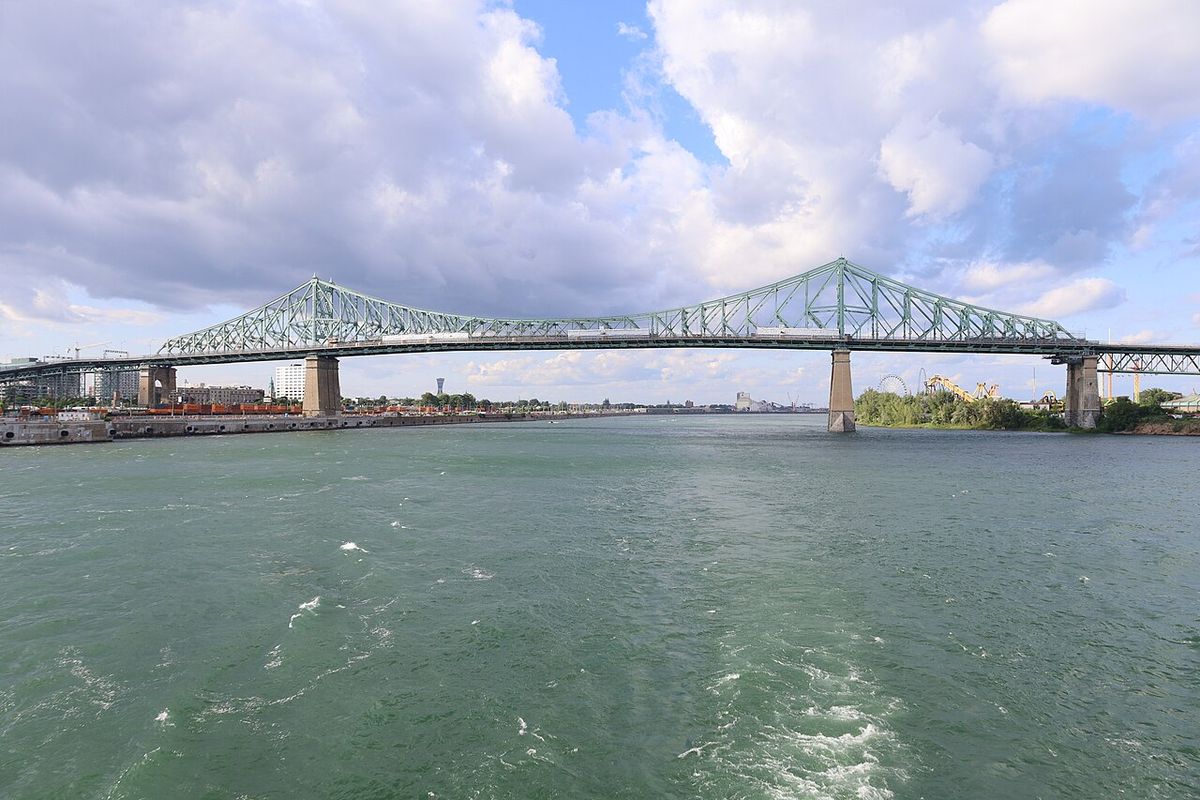
The district is composed of several distinct and well-known Montreal neighbourhoods, each contributing to its unique character. The Plateau Mont-Royal area is known for its arts scene, row houses, and commercial streets like Saint-Laurent Boulevard and Saint-Denis Street. Mile End is a neighbourhood with bagel shops, cafés, and a mix of artistic and immigrant communities. Côte Saint-Louis is a residential area with a strong community identity. The portion within Ville-Marie borough includes the eastern edge of Montreal's downtown core, with its business towers and institutions, and the western part of Centre-Sud, a historically working-class area. The inclusion of Saint Helen's Island and Notre Dame Island following the 2022 redistribution adds major parkland and tourist sites like Parc Jean-Drapeau and the Biosphere to the riding's geography. These islands are located in the Saint Lawrence River and are connected to the mainland by the Jacques Cartier Bridge.
The district includes Côte Saint-Louis and the eastern parts of the Plateau and Mile End in the Borough of Le Plateau-Mont-Royal. It also includes the eastern part of Downtown Montreal and the western part of Centre-Sud, including part of the neighbourhood of Sainte-Marie, in the Borough of Ville-Marie. Following the 2022 redistribution, the riding lost territory south of Avenue Christophe-Colombe and west of Rue Rachel to Outremont. It also gained territory north of Boulevard Robert-Bourassa and east of Avenue Viger, including Saint Helen's Island and Notre Dame Island, from Ville-Marie, Le Sud-Ouest, Île-des-Soeurs.
- Côte Saint-Louis (in Le Plateau-Mont-Royal borough).
- Eastern parts of the Plateau (in Le Plateau-Mont-Royal borough).
- Eastern parts of Mile End (in Le Plateau-Mont-Royal borough).
- Eastern part of Downtown Montreal (in Ville-Marie borough).
- Western part of Centre-Sud, including part of Sainte-Marie (in Ville-Marie borough).
- Saint Helen's Island (gained in 2022 redistribution).
- Notre Dame Island (gained in 2022 redistribution).
Key Political Figures and Electoral Dynamics
Several prominent Canadian politicians have been directly associated with the Laurier, Sainte-Marie riding, shaping its political legacy. The riding has also been represented by other MPs since its creation, contributing to its political narrative. The local riding associations for the Liberal, Conservative, New Democratic, Bloc Québécois, and Green parties operate within the district, organizing volunteers and campaign activities for their respective candidates during elections. These associations are the official local branches of the federal political parties.
Related Electoral Districts and Historical Context
Laurier, Sainte-Marie is part of a network of federal electoral districts in Montreal with interconnected histories. It was created from parts of the former Laurier, Montreal, Sainte-Marie, and Saint-Jacques ridings, which are now historical federal electoral districts of Canada. When it was abolished in 2003, its territory was divided between the newly configured Laurier and Hochelaga ridings. The neighbouring ridings that have exchanged territory with Laurier, Sainte-Marie through redistributions include Outremont, Ville-Marie, Le Sud-Ouest, Île-des-Sœurs, Hochelaga, and Westmount, Ville-Marie. Understanding these relationships is key to analysing voter migration and the political evolution of central Montreal. The riding's demographic and economic data is officially compiled by Statistics Canada, with the 2011 census profile available under code 24031.
Questions about Laurier-Sainte-Marie
Where is the Laurier, Sainte-Marie riding located?
Laurier, Sainte-Marie is located in central Montreal, Quebec. It spans parts of two boroughs: Le Plateau-Mont-Royal and Ville-Marie. Specifically, it includes Côte Saint-Louis, eastern Plateau, eastern Mile End, eastern downtown Montreal, and western Centre-Sud, including part of Sainte-Marie. Following the 2022 redistribution, it also includes Saint Helen's Island and Notre Dame Island, which are located in the Saint Lawrence River.
What is the population and demographic makeup of the riding?
According to the 2016 census, the riding had a population of 111,835. More recent 2021 census data shows a diverse population: 73.4% White, with significant Black (5.1%), Arab (4.4%), Latin American (4.3%), Chinese (3.7%), and South Asian (3.1%) communities. The most common language is French (67.2%), followed by English (15.7%). A majority of residents (52.7%) report no religious affiliation, while 29.1% are Catholic. The median income in 2020 was $39,600.
Why is the riding called Laurier, Sainte-Marie?
The riding's name combines two local landmarks. 'Laurier' refers to Laurier Avenue, a major street in the Plateau Mont-Royal neighbourhood that is named after former Prime Minister Sir Wilfrid Laurier. 'Sainte-Marie' refers to the historic name for the Centre-Sud area, which comes from a parish church in that neighbourhood that was dedicated to Saint Mary. The district was created in 1987 from parts of ridings that included these areas, and the name was reinstated in 2004 after a brief period where the riding was simply called 'Laurier'.
How have the riding's boundaries changed over time?
The riding was created in 1987 from parts of Laurier, Montreal, Sainte-Marie and Saint-Jacques ridings. It was abolished and redistributed into Laurier and Hochelaga ridings in 2003, and then re-established under its original name in 2004. Its boundaries were adjusted in the 2012 electoral redistribution, losing and gaining territory from neighbouring ridings including Outremont and Hochelaga. The most recent change followed the 2022 federal electoral redistribution, where it lost territory south of Christophe-Colomb Avenue to Outremont and gained Saint Helen's Island and Notre Dame Island from Ville-Marie, Le Sud-Ouest, Île-des-Soeurs.
Who is the current Member of Parliament for Laurier, Sainte-Marie?
The notes detail that the riding was represented by Gilles Duceppe, leader of the Bloc Québécois, until 2011. In that year, he was defeated by Hélène Laverdière of the New Democratic Party. The riding has been represented in the House of Commons since the 1988 federal election. The provided demographic and geographic information is from the 2021 census and 2023 representation order, but the current MP after the 2021 election is not listed in the given text.
What was the political significance of Gilles Duceppe in this riding?
During his tenure, he also served as the leader of the Bloc Québécois. His representation made the riding a significant political base for the sovereigntist party at the federal level. Duceppe's defeat in the 2011 federal election by Hélène Laverdière of the New Democratic Party marked a major shift for the constituency. This event was part of a broader change in Quebec politics during that election cycle.
Sources: Wikipedia and current public reporting, checked by the Your Space Hamilton desk. Last updated 2026-10-20.