Super El Niño Likely to Bring Historic Weather Impacts to Canada in 2026-2027
A strengthening 'super' El Niño could lead to record warm temperatures, drought risks in western Canada, and unusual winter conditions across the country, according to meteorologists.
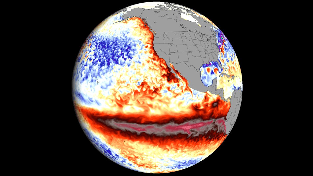
The developing 'super' El Niño climate pattern in the Pacific Ocean is poised to bring significant and potentially record-breaking weather impacts to Canada through the 2026-2027 winter and spring seasons. Meteorological experts warn this event could rank among the strongest El Niño patterns ever recorded, with far-reaching consequences for regional weather patterns, water resources, and ecosystems across the nation.
The Science Behind the Super El Niño
CityNews chief meteorologist Natasha Ramsahai provided detailed analysis of this climate phenomenon based on forecasts from the National Oceanic and Atmospheric Administration (NOAA). She explained how El Niño forms through complex ocean-atmosphere interactions in the Pacific. The cycle begins when equatorial trade winds weaken, allowing warm surface waters that normally pool in the western Pacific to shift eastward toward South America. Ramsahai described the process: 'When those trade winds are strong, they blow the hottest of the water in the Pacific westward allowing cooler water to upwell from below near South America. When those winds relax, that hot water starts flooding back... and that hot water pool sits through the middle and eastern parts of the Pacific.'
The intensity of an El Niño event depends on the degree of warming in these Pacific waters compared to average conditions. Current measurements show temperatures in the key monitoring zone ranging from 1.89 to 2 C above average as of August, approaching the 'super' El Niño threshold of 2 C above average. Some forecast models suggest this winter could see temperatures 3 or 4 C above average, potentially surpassing the record of 2.4 C set during the intense 1982-1983 event. Ramsahai noted the rapid development of this El Niño has challenged forecasting capabilities: 'Since the spring, we've had such a rapid transition that the forecast models can't even keep up.'
Western Canada Faces Severe Drought Risk
The most dramatic impacts are projected for western Canada and through the Prairies into northwestern Ontario. Ramsahai predicts consistently warm and dry conditions throughout the winter continuing into spring and summer 2027. This pattern could lead to significantly reduced snow accumulation in mountainous and northern regions. The meteorologist outlined the cascading effects: 'That means a reduction in snow melt, a reduction in insulation, and an increase in wildfire and drought risk.' She emphasized this combination creates particularly dangerous conditions when combined with Canada's recent trend of intense wildfire seasons.
The lack of substantial snowpack would affect more than winter recreation and tourism. Mountain snowpacks serve as natural water storage reservoirs, gradually releasing moisture during spring melt to replenish rivers, lakes and groundwater systems across western provinces. Reduced meltwater could strain multiple sectors including agricultural irrigation, hydroelectric power generation, and municipal water supplies. The drought risk extends beyond immediate water shortages, potentially impacting forest health, wildlife habitats, and air quality through increased dust and wildfire smoke.
Eastern Canada's Variable Forecast
While western regions prepare for warmth and dryness, eastern Canada faces a more complex set of potential impacts. Ramsahai's analysis suggests Quebec and most of the Maritimes may experience cooler than normal conditions this winter, creating a stark east-west temperature divide across the country. Southern Ontario's forecast includes increased risks of freezing rain events and flooding, along with more frequent freeze-thaw cycles that accelerate road deterioration and pothole formation.
The Great Lakes region could see some benefits from reduced ice buildup on the waterways, potentially extending the commercial shipping season. However, agricultural sectors dependent on cold weather, particularly maple syrup and ice wine production, may face challenges if temperatures remain too mild for optimal production conditions. Ramsahai cautioned that these projections come with significant uncertainty due to the volatile nature of El Niño-influenced weather patterns, noting that surprise changes remain possible as the season develops.
Hurricane Season Impacts
The developing El Niño has already demonstrated its far-reaching influence by suppressing Atlantic hurricane activity. As of mid-September, no major hurricanes had formed in the Atlantic basin - an unusual occurrence that meteorologists attribute to the emerging El Niño pattern. Ramsahai provided historical context, noting that in 2002 and 2013, the first major hurricanes of those seasons began on September 11, marking the latest starts since satellite tracking began in 1966.
This temporary reduction in hurricane activity offers some relief for Atlantic Canada, which has endured several destructive storms in recent years. However, Ramsahai emphasized that hurricane risks can change rapidly even during El Niño years, and coastal regions should maintain preparedness for potential late-season storm activity. The current pattern reflects the complex ways El Niño can influence weather systems thousands of kilometers from its Pacific origin.
Historical Context and Climate Change
The current El Niño event shows potential to surpass historical records in both intensity and duration. NOAA forecasts suggest greater than 90% probability of a 'historic' event peaking this winter but possibly lasting through spring 2027. Ramsahai explained that El Niño typically alternates with cooler La Niña conditions every two to seven years as part of a natural climate cycle called the El Niño-Southern Oscillation (ENSO). However, the rapid development and projected strength of this El Niño make it particularly noteworthy.
Importantly, Ramsahai clarified that El Niño effects occur in addition to existing climate change trends, potentially amplifying temperature and precipitation anomalies worldwide. While El Niño represents a natural climate pattern, its impacts now unfold against the backdrop of a warming planet, creating new complexities in weather prediction and climate modeling. This interaction between short-term climate variability and long-term warming trends presents challenges for scientists and policymakers attempting to anticipate and prepare for extreme weather events.
Preparing for the Impacts
The potential strength and duration of this El Niño event could have significant consequences for Canada's environment, infrastructure, and economy. Municipalities in western regions may need to implement early water conservation measures and enhance wildfire preparedness programs. Agricultural producers across the country should prepare for shifting growing conditions and potential impacts to crops and livestock.
Infrastructure managers face particular challenges from expected freeze-thaw cycles in Ontario and possible flooding events. Transportation networks may require additional maintenance to address accelerated road deterioration, while energy systems could experience shifting demand patterns due to unusual temperature regimes. While some impacts like reduced hurricane threats and extended Great Lakes shipping offer potential benefits, the overall pattern suggests a season of weather extremes that will test emergency response systems nationwide.
This developing El Niño serves as both a significant weather event and a case study in how global climate phenomena increasingly interact with local conditions in a warming world. As Ramsahai's analysis demonstrates, understanding these complex interactions becomes ever more critical for preparing communities and industries for the challenges of a changing climate. The event underscores the importance of continued investment in climate monitoring, forecasting capabilities, and adaptive infrastructure to meet the needs of Canada's diverse regions facing these evolving weather patterns.