North American blizzard of 2006
The North American blizzard of 2006 was a major nor'easter that struck eastern North America from February 11 to 13, 2006. It delivered historic snowfall totals from the Mid-Atlantic states through New England and into Atlantic Canada, paralysing major metropolitan areas. For New York City, the storm set a new single-storm snowfall record of 26.9 inches (68 cm) in Central Park, a benchmark that stood for nearly a decade. The event is remembered for its intense, localised snowfall rates, widespread travel disruptions, and its relatively low casualty count due to favourable conditions for cleanup.
Meteorological Development and Characteristics
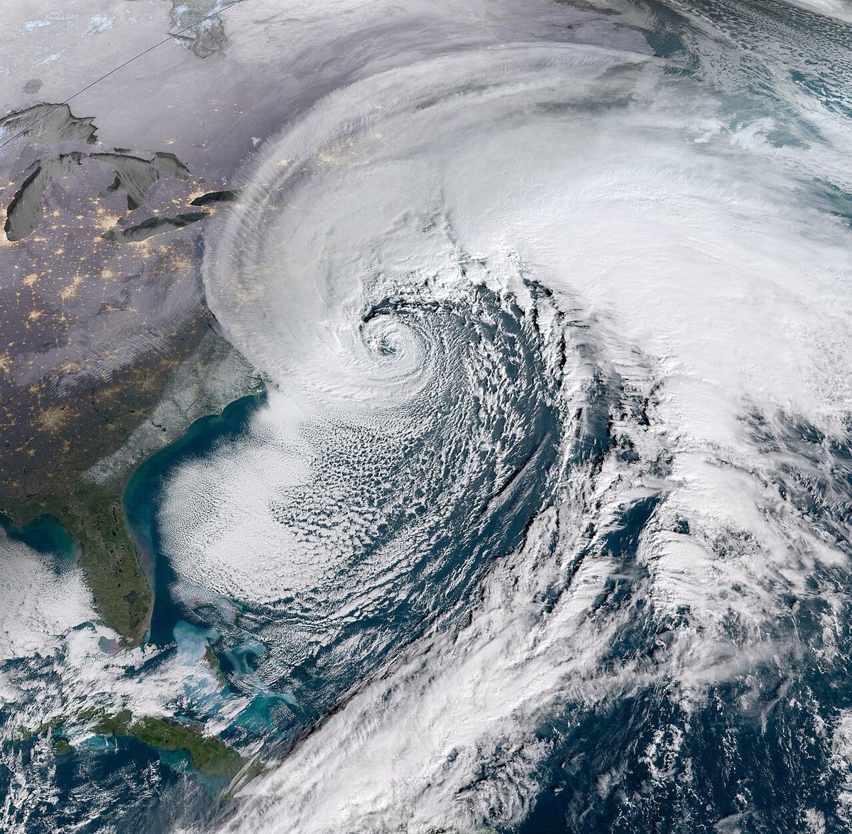
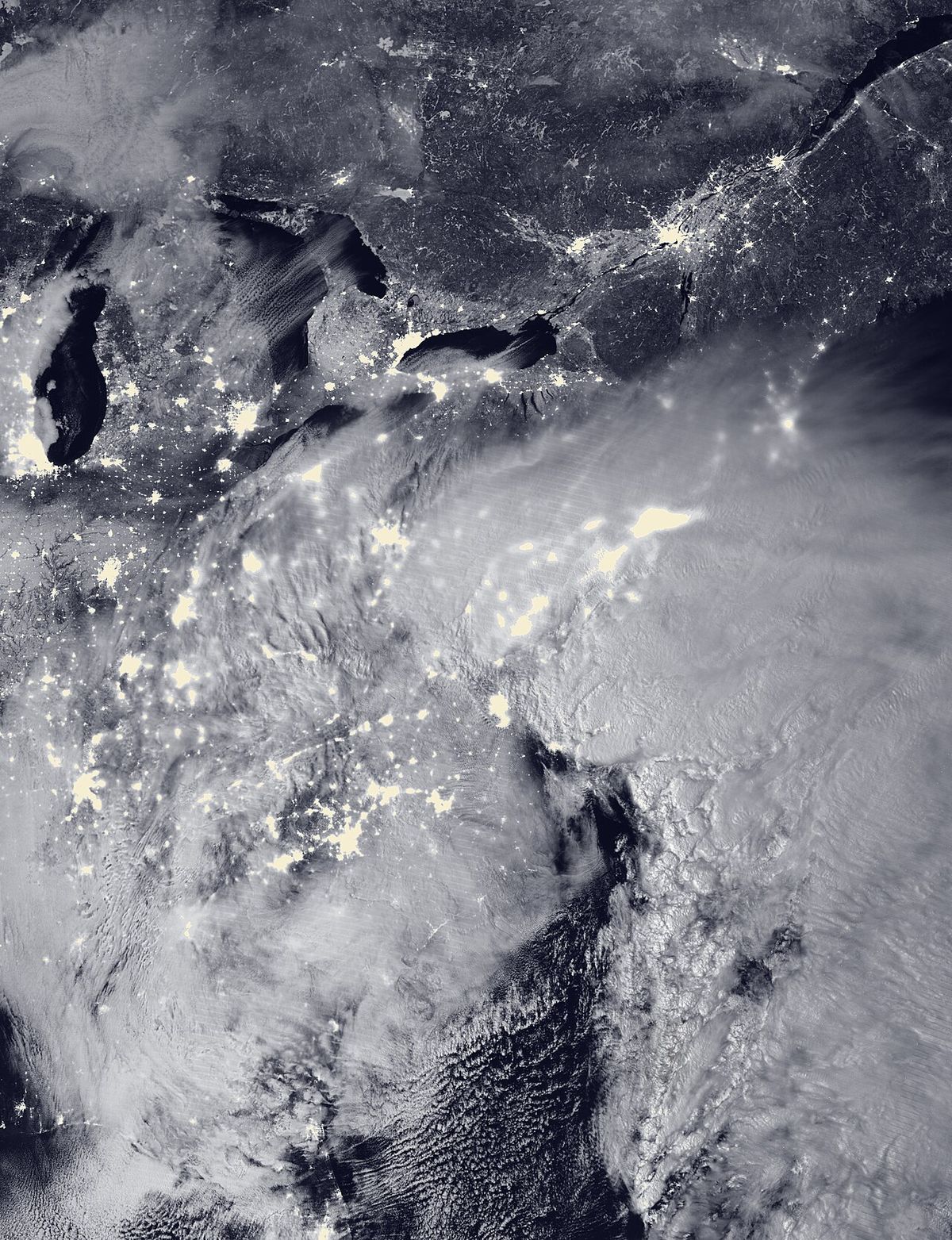
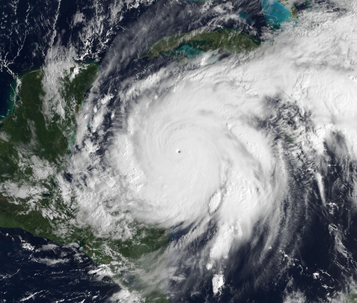
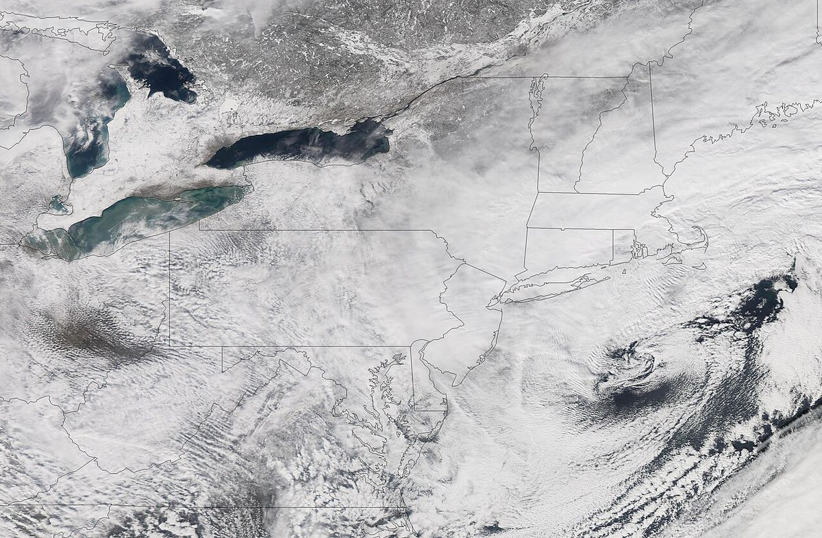
The storm system began as a minor low-pressure area developing over the southern Appalachian Mountains on February 11. It moved offshore early on February 12 before undergoing rapid intensification, a process known as bombogenesis, fuelled by unusually warm Atlantic Ocean water temperatures for February. This explosive deepening led to the formation of intense mesoscale snowbands that set up along the Interstate 95 corridor. Remarkably, the cyclone became so well-defined that a clear eye formed, a feature rarely observed in extratropical storms, which was captured in a satellite image by NASA. The storm's centre was located south and east of New Jersey at its peak intensity. Throughout the event, temperatures remained well below freezing, producing a dry, light snow that was easier to remove than wet, heavy snow. Thunder and lightning, a phenomenon known as thundersnow, were reported during the height of the storm on the morning of February 12 in several states including New York, New Jersey, and Maryland. The storm's relatively small geographic footprint of extreme snowfall, combined with its occurrence on a weekend, contributed to its official classification as a low-end Category 3 (Major) event on the Northeast Snowfall Impact Scale.
Snowfall and Wind Records
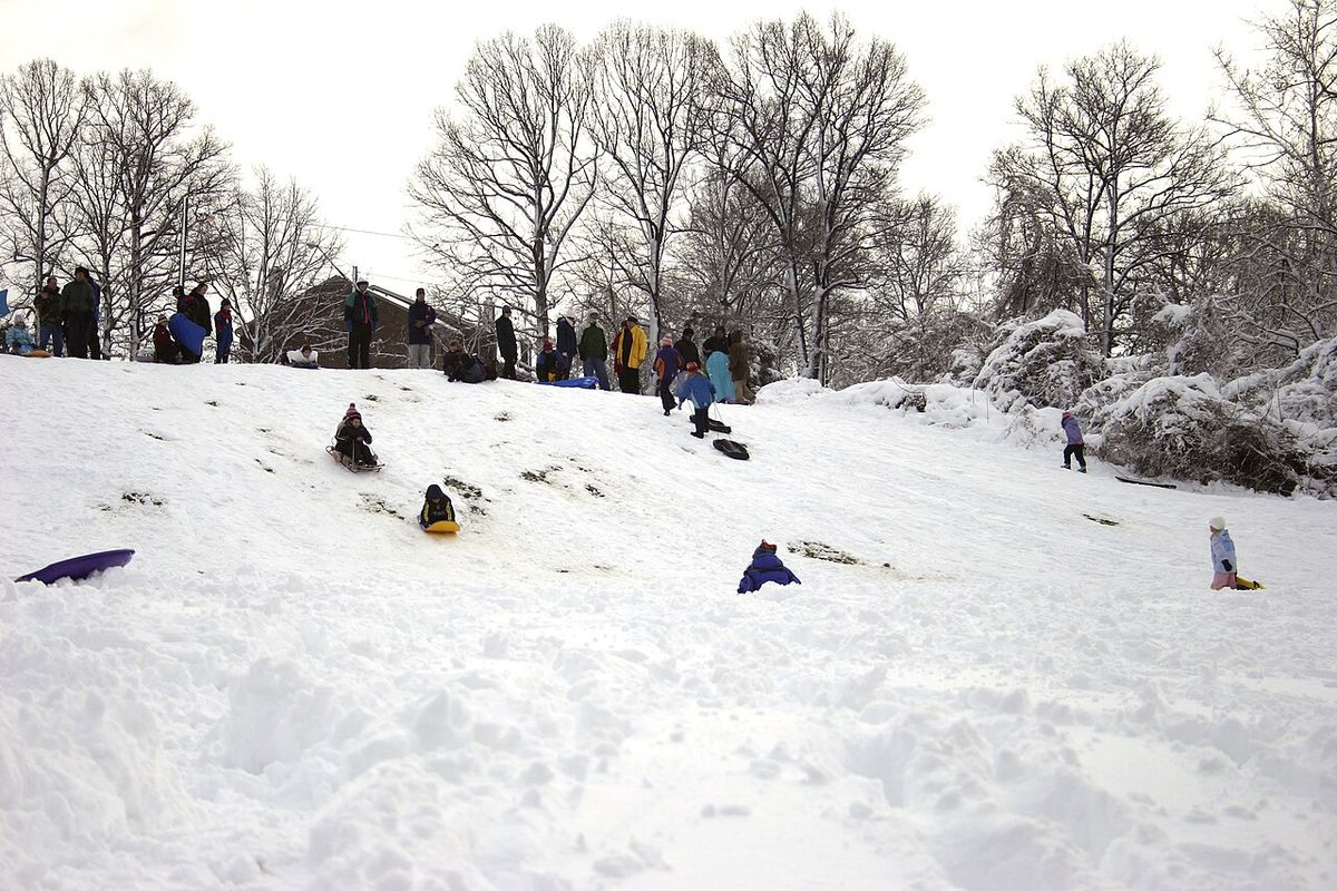
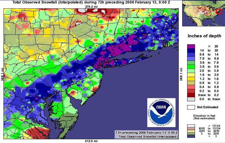
The blizzard produced exceptionally high snowfall accumulations within a concentrated geographic area stretching from northern Virginia to southern New England. The heaviest snow was confined to this heavily populated corridor, leading the National Weather Service to classify it as a Category 3 (Major) event on the Northeast Snowfall Impact Scale (NESIS). New York City's Central Park recorded 26.9 inches, setting a new all-time single-storm record that surpassed the previous mark of 26.4 inches from 1947. Other notable accumulations included 27.8 inches in Fairfield, Connecticut, 27 inches in Rahway, New Jersey, and 21.9 inches in Hartford, Connecticut. As the storm moved into Atlantic Canada on February 13, snowfall amounts diminished to between 6 and 12 inches, but wind speeds increased dramatically. Hurricane-force wind gusts were recorded, peaking at 156 km/h (97 mph) in Grand Etang, Nova Scotia, which is equivalent to a Category 2 hurricane. These winds caused damage to power lines and buildings along the Atlantic coast. A second notable wind gust of 133 km/h (83 mph) was recorded at Cape Race on the east coast of Newfoundland. Coastal flooding from a storm surge of up to 3 feet was also reported in parts of New England, particularly in Massachusetts.
Impact by Region
The storm's impacts varied significantly across the affected regions, with the most severe conditions centred on the New York metropolitan area. In New York, all three major airports were closed for the first time since the September 11, 2001 attacks. The Long Island Rail Road reported extensive delays and as many as eight trains disabled for several hours, with service not fully normalised until Tuesday, February 14. Snow removal costs for the city alone were estimated at $27 million. Power outages affected up to 300,000 customers at their peak, and strong winds caused $3 million in property damage across the state. In Connecticut, despite being one of the hardest-hit areas, the state was well-prepared. Governor M. Jodi Rell ordered all tractor-trailers off highways and mandated snow chains for non-four-wheel-drive vehicles on state roads, mobilising 2,500 state-owned and privately contracted plows. Bradley International Airport was closed for several hours and Metro North service was disrupted. Maryland experienced the most significant power outages, with over 62,000 customers losing electricity in the Baltimore area, plus another 16,000 in Montgomery County and 37,000 in Prince George's County. Massachusetts faced serious coastal issues, with storm surges of 2 to 3 feet and offshore waves up to 25 feet causing flooding, particularly around Nantucket. Logan International Airport in Boston saw over 90 percent of flights cancelled. Rhode Island's Governor Donald Carcieri declared a statewide state of emergency, while in Atlantic Canada, the primary impact shifted from snow to destructive winds that downed power lines.
Key snowfall totals from major reporting stations included 26.9 inches (68 cm) in New York City's Central Park, which was a record for a single storm since records began in 1869. Hartford, Connecticut, received 21.9 inches (56 cm), its second largest snowfall since 1906. Newark Airport in New Jersey reported 21 inches (53 cm) of snow. In Massachusetts, the central part of the state saw up to 20 inches (51 cm), while coastal areas like Nantucket saw approximately 12 inches. Washington, D.C., received about 10 inches (25 cm) of snow, which was less than its suburbs.
- New York, NY (Central Park): 26.9 inches (68 cm)
- Newark, NJ: 21 inches (53 cm)
- Hartford, CT: 21.9 inches (56 cm)
- Columbia, MD: up to 21 inches (53 cm)
- Philadelphia, PA (Airport): 12 inches (30 cm)
- West Caln Township, PA: 21 inches (53 cm)
- Baltimore, MD: 13.1 inches (33 cm)
- Washington, D.C.: approx. 10 inches (25 cm)
- Providence, RI: between 9 and 19 inches (23-48 cm)
- Boston, MA area: up to 20 inches (51 cm)
- Wilmington, DE: 14 to 15 inches (36-38 cm)
Transportation and Infrastructure Disruption
The blizzard caused massive disruptions to air, rail, and road travel across the Northeast. The closure of New York's LaGuardia, John F. Kennedy, and Newark Liberty airports, alongside Washington's Reagan National Airport and Boston's Logan International Airport, led to the cancellation of thousands of flights. Philadelphia International Airport remained open but cancelled about 50 percent of its flights. On the ground, New Jersey Transit suspended all bus service between 7:30 a.m. and 4:00 p.m. on February 12, although trains continued with delays. The Long Island Rail Road reported severe delays, with as many as eight trains becoming disabled, and service was not fully restored to normal until two days after the storm. Many state highways and local roads were closed or made impassable, with Connecticut implementing strict travel restrictions for commercial vehicles and requiring snow chains. Despite the record snowfall, New York City's public schools famously remained open on February 13, a result of planning and work by the city's snowplow teams. Philadelphia's public and parochial schools were closed for the day. Utility crews worked for nearly two days to restore power to hundreds of thousands of customers from Virginia to New York.
Casualties and Economic Costs
The storm was directly linked to three fatalities. In Virginia, a man died when his truck slid off a highway. In Baltimore, a person died in a house fire as snow delayed rescue workers from reaching the scene. A third weather-related fatality occurred in Nova Scotia. An additional death was reported in Billerica, Massachusetts, where a tree fell onto a pickup truck, killing the driver. Despite the historic scale of the storm, the overall casualty count was considered low. Analysts attributed this to several factors, including the storm occurring on a Sunday when fewer people were commuting, the dry nature of the snow which made cleanup faster, and effective emergency preparedness and response. The economic costs were substantial, with New York City's snow removal bill hitting $27 million. Property damage from fallen trees and power lines was also significant, with Massachusetts reporting $1.9 million in damage and New York State reporting $3 million in damage, both figures in 2006 US dollars. The warm temperatures that followed the storm, reaching the mid-50s °F in New York City, helped melt the snow quickly and reduced longer-term economic impacts.
Government and Emergency Response
Government response to the storm was swift and largely effective, varying by jurisdiction. States like Connecticut and Rhode Island implemented proactive measures, with Rhode Island's governor declaring a state of emergency. Connecticut's Governor M. Jodi Rell issued orders to keep tractor-trailers off highways and mandated snow chains, while mobilising a fleet of 2,500 plows. The state's 169 towns and cities deployed hundreds of additional plows for local roads. These actions kept major highways open and facilitated a quicker recovery. In New York City, the coordination of snow removal efforts allowed public schools to open just one day after the record snowfall. Power restoration was a major priority, with crews working around the clock to address outages that at one point affected 62,000 people in Baltimore, 64,000 in Northern Virginia, 16,000 in New Jersey, and thousands more across the region. The low casualty count is often cited as evidence of the effectiveness of these coordinated responses, which kept non-essential travel to a minimum during the storm's peak.
Comparative Historical Context
The 2006 blizzard holds a distinct place in the climatological history of the Northeastern United States. Its 26.9-inch total in New York City made it the snowiest single storm since official records began in 1869, a record it held until being surpassed by the January 2016 United States blizzard nearly a decade later. The storm also contributed to a rare seasonal anomaly: the 2005-06 winter became the first on record where New York City received more seasonal snowfall than Albany, New York, which typically averages about twice as much snow. When compared to other major nor'easters, the 2006 event dropped more snow in New York than the blizzards of 1996 (20.2 inches) and 2003 (19.8 inches). Its intensity and impact have led it to be grouped with other major storms occurring in years ending in '6', such as those in 1996 and 2016, forming a notable pattern in regional weather history. The storm's characteristics, including its rapid intensification and the formation of an eye, also make it a frequent subject of meteorological case studies on extreme extratropical cyclones.
Aftermath and Long-Term Significance
In the immediate aftermath, cleanup was expedited by unseasonably warm temperatures that melted snow rapidly in cities like New York and Washington. This natural melting, combined with aggressive mechanical removal, allowed major cities to reopen schools and businesses within a day or two. The storm's legacy includes highlighting the importance of coordinated regional preparedness for extreme winter weather events in densely populated areas. It demonstrated the effectiveness of pre-emptive travel restrictions and large-scale plow mobilisation. The event also showed how specific meteorological factors, such as dry snow and a weekend timeline, can mitigate the human and economic toll of even record-setting storms. For many communities from Virginia to Maine, the blizzard of 2006 remains a benchmark event against which subsequent winter storms are measured, remembered for its dramatic snowfall totals and the relative efficiency of the recovery effort.
Questions about North American blizzard of 2006
How much snow did New York City get in the 2006 blizzard?
New York City's Central Park recorded 26.9 inches (68 cm) of snow from the blizzard. This set a new all-time record for the greatest snowfall from a single storm since official records began in 1869. The record stood for nearly ten years until it was broken by a blizzard in January 2016. The snowfall was so historic that it even contributed to New York City receiving more seasonal snow than Albany for the first time on record.
Why were casualties so low in such a major storm?
Only three fatalities were directly linked to the blizzard, which is considered low for a storm of its magnitude. Several factors contributed to this. The storm hit on a Sunday, meaning far fewer people were commuting or travelling. The snow was dry and light due to consistently cold temperatures, making it easier and faster to clear than heavy, wet snow. Effective emergency preparedness, including travel bans and the early deployment of plows, helped keep people off dangerous roads and facilitated a quicker recovery.
Which airports were closed because of the blizzard?
The blizzard led to the complete closure of all three major airports serving the New York City area: LaGuardia Airport, John F. Kennedy International Airport, and Newark Liberty International Airport. This was the first time they had all been closed simultaneously since the September 11, 2001 attacks. Other major airport closures included Ronald Reagan Washington National Airport near Washington, D.C., and Logan International Airport in Boston, where over 90 percent of flights were cancelled at the storm's peak. Bradley International Airport in Connecticut was also closed for several hours.
What was the impact on Atlantic Canada?
By the time the storm reached Atlantic Canada on February 13, snowfall had diminished to between 6 and 12 inches. However, the winds intensified dramatically, becoming the primary hazard. Hurricane-force wind gusts were reported, with a peak of 156 km/h (97 mph) recorded in Grand Etang, Nova Scotia. These powerful winds caused damage across the region, including downed power lines and some structural roof damage, particularly along the coasts of the Bay of Fundy, the Northumberland Strait, and southern Newfoundland. A third storm-related fatality was also reported in Nova Scotia.
How did the 2006 blizzard compare to the Blizzard of 1996?
While both were major nor'easters, the 2006 blizzard produced a higher single-storm snowfall total in New York City. Central Park received 26.9 inches in 2006, compared to 20.2 inches from the 1996 storm. Interestingly, the 2006 event did not technically meet the official meteorological criteria for a blizzard in New York because sustained wind speeds and visibility reductions were not severe enough, whereas the 1996 storm did qualify. The 2006 storm was also more geographically concentrated in its heaviest snowbands compared to the broader impact of the 1996 event.
What made the storm's meteorology unusual?
Several meteorological aspects of the storm were notable. It underwent rapid intensification, or bombogenesis, fuelled by warmer-than-usual Atlantic Ocean temperatures. This process created extremely intense snowbands. Most unusually, the extratropical cyclone developed a clear eye, a feature almost exclusively associated with hurricanes. A NASA satellite image captured this eye located south and east of New Jersey. The storm also produced thundersnow, thunder and lightning within snowbands, in several states, a relatively rare phenomenon for the Northeast observed for about a four-hour period in parts of New York City and surrounding counties.
Sources and further reading
- North American blizzard of 2006 (Wikipedia)
- Past Weather Events (weather.gov)
Checked by the Your Space Hamilton desk. Last updated 2026-10-28.