Barnes Ice Cap
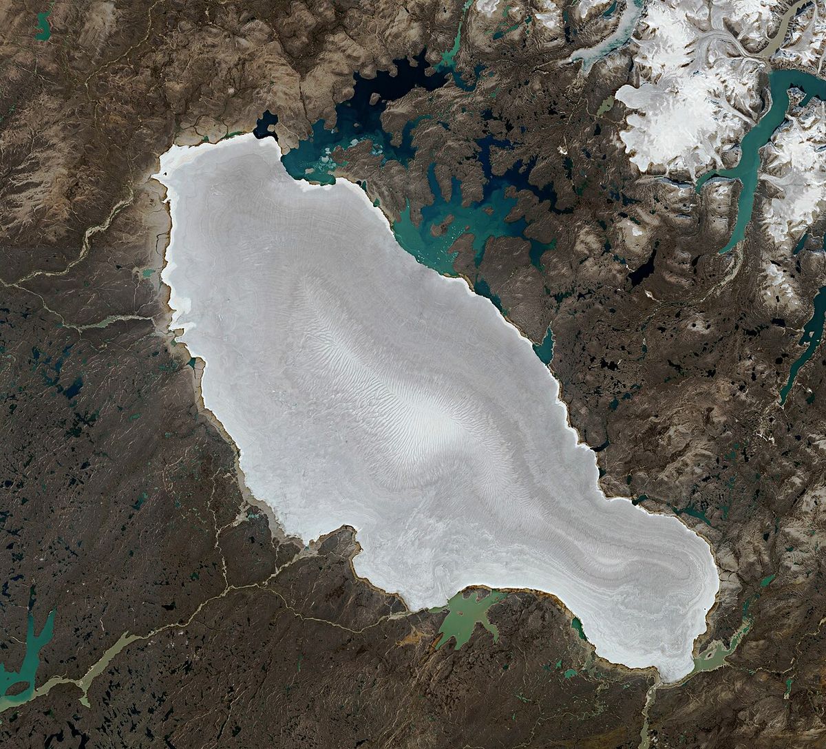
The Barnes Ice Cap is a vast ice cap located in the central region of Baffin Island, Nunavut, Canada. It is the last significant remnant of the Laurentide Ice Sheet, which once blanketed most of Canada during the last ice age. Covering approximately 6,000 square kilometres, it contains some of the oldest ice in Canada, with sections dating back over 20,000 years. The ice cap is a critical subject of scientific study due to its rapid thinning and retreat, which serve as a clear indicator of climate change in the Canadian Arctic. Its projected disappearance within the next few centuries highlights the lasting impact of human-caused warming on the northern environment.
Geography and Physical Characteristics
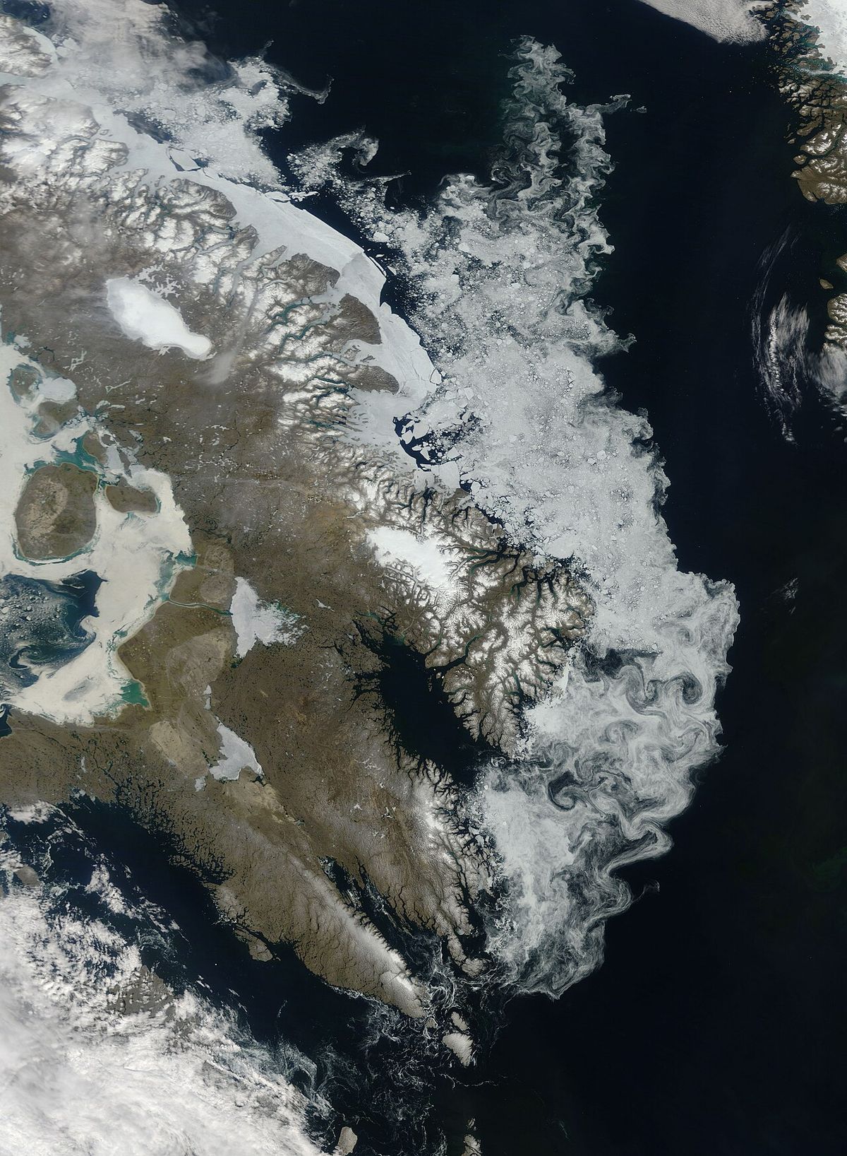
The Barnes Ice Cap is situated in the Baffin Mountains, dominating the central interior of Baffin Island. It spans roughly 150 kilometres in length and 60 kilometres in width, with a distinctive bowling-pin shape. The ice cap's summit, known as the north dome, reaches a maximum elevation of 1,124 metres above sea level. Its ice is up to 730 metres thick in places, resting on underlying bedrock that slopes from northeast to southwest, influencing internal ice flow dynamics. The southeastern end of the ice cap is adjacent to Generator Lake, while several small rivers, including the MacDonald and Flyway Rivers, drain meltwater from its southwestern margins into lakes and ultimately Foxe Basin. The ice cap's surface is characterized by a network of persistent supraglacial channels and meltwater valleys that have expanded significantly in recent decades, efficiently transporting water off the ice.
This feature holds a unique climatic archive as a direct vestige of the Laurentide Ice Sheet, which episodically covered millions of square kilometres of North America during the Quaternary Period. Its ice layers preserve a continuous record of atmospheric conditions stretching back millennia. Scientific analysis of this ice confirms that some sections are over 20,000 years old, making them the oldest known ice in Canada. The preservation of this ancient ice demonstrates the ice cap's long-term stability until the modern era of rapid warming began to take effect, providing researchers with a direct link to the last glacial period and a baseline for measuring contemporary change.
Recent Changes and Thinning
The Barnes Ice Cap has undergone significant and accelerating change over the past century. Observational data indicates it has lost between 15 and 20 percent of its total mass over the last 125 years. Thinning rates have increased markedly, with satellite altimeter data showing an average thinning of 0.75 metres per year between 2003 and 2009. From 2000 to 2020, the overall thinning rate was approximately one metre per year. This thinning is not uniform across the ice cap, with some areas, particularly on the central-southern margin, retreating much faster.
The ice cap's health is fundamentally linked to its snow cover, or firn, which acts as a reflective blanket and a reservoir for meltwater that can refreeze. A critical threshold was crossed around 2010 when the ice cap lost its persistent accumulation area. Since then, the equilibrium line altitude, the boundary between accumulation and ablation zones, has risen above the ice cap's crest. This means the entire surface is now subject to net melting each year. This negative balance has been sustained, driving continued ice loss and the expansion of drainage channels that prevent refreezing.
The summer of 2026 provided a dramatic example of these accelerating processes. The ice cap entered the melt season with an already thin snowpack due to warm winter conditions. Landsat satellite imagery revealed that by mid-July 2026, the Barnes Ice Cap had lost all of its snow cover, the earliest recorded date for such complete exposure. This early baring of the darker underlying ice significantly accelerated melting, as dark ice absorbs more solar energy than reflective snow. The event also led to the full activation of the ice cap's extensive network of supraglacial streams, which began channeling meltwater off the ice cap weeks earlier than typical, further reducing any chance of refreezing and adding to the season's substantial mass balance loss.
Scientific Research and Future Projections
Researchers from institutions like Simon Fraser University and the University of Colorado Boulder have used field observations, satellite data, and sophisticated ice flow models to understand its past and project its future. A landmark 2017 study published in Geophysical Research Letters modeled the ice cap's fate under various greenhouse gas emissions scenarios. The study concluded that, under a business-as-usual emissions trajectory, the Barnes Ice Cap will completely disappear within the next 300 years. Even under the most conservative scenarios where emissions decline substantially, the ice cap is projected to vanish in less than 500 years.
This research placed the current melting into a deep historical context. By analysing rock samples around the ice cap's margins, scientists determined that it is extremely rare for the ice cap to shrink to its current small size or disappear entirely. Over the past 2.5 million years, the ice cap has likely disappeared no more than twice, and only shrunk to its modern extent on three occasions. The study's authors noted that the current level of warming driving this loss is almost unprecedented in that entire period. Glaciologist Gifford Miller, a co-author of the study, emphasized that while the ice cap's disappearance itself would have a negligible impact on sea level, it serves as a potent indicator. He stated that its fate carries information about the vulnerability of much larger ice bodies, suggesting that given enough time on the current climate path, large portions of the Greenland Ice Sheet could also be at risk of similar decline.
Recent scientific assessments indicate the Barnes Ice Cap is thinning and losing mass. The ice cap entered the 2026 melt season with a thin snowpack and lost its snow cover by mid-July, the earliest recorded. Over the past 125 years, the ice cap has lost 15 to 20 percent of its total mass. A 2017 study projects the ice cap will disappear within the next 300 years under a business-as-usual greenhouse gas emissions scenario.
- The ice cap is melting at all elevations, with no sustained accumulation zone.
- The primary mechanism for mass loss has shifted from surface melt and refreezing to efficient runoff through persistent channels.
- Winter conditions in the region have been 3 to 5 degrees Celsius above average, contributing to thin snowpacks.
- The ice cap's disappearance is now considered virtually inevitable under all plausible future climate scenarios.
- Its demise would mark the final end of the Laurentide Ice Sheet, a feature that has existed in some form for millions of years.
Historical Exploration and the 1995 Expedition
The first recorded bicycle traverse of the Barnes Ice Cap was completed in 1995 by a team sponsored by the Wyoming Alpine Club. The expedition members were brothers Mike and Dan Moe, who were among the first to complete the Continental Divide mountain biking route from Canada to Mexico, along with Sharon Kava and Brad Humphrey. The team successfully crossed the ice cap on their bicycles, which were outfitted for the Arctic terrain. Upon reaching the western side on August 22, 1995, they abandoned their bikes and sleds at coordinates 70°31′43″N 73°18′42″W to expedite their travel over difficult boulder fields toward Baffin Bay, intending to retrieve the equipment later. Tragedy struck the party after they left the ice cap while traveling by boat along the coast.
Their aluminum vessel, captained by Innumariik guide Jushua Ilauq of Clyde River, was capsized by a breaching bowhead whale. All four members of the 1995 biking expedition died of hypothermia. Ilauq alone survived the accident due to wearing a cold-weather survival suit, and he lived until 2025. The story of the expedition and its tragic end was chronicled by writer Mark Jenkins, a childhood friend of Mike Moe, in Outside magazine in 2006 and again in 2022.
Broader Environmental Context
The changes observed at the Barnes Ice Cap are not isolated but part of a broader pattern of glacial retreat across the Canadian Arctic and Baffin Island. In the same mid-July 2026 period when the Barnes Ice Cap lost its snow cover, a series of glaciers to its east, including Keyhole, Kitarchick, and Nuusuq Glaciers, also became completely bare. The Decade Icefield, located just north of this group, similarly lost all snow cover. This synchronous early melting across multiple ice bodies indicates widespread regional warming and reduced winter snowfall. The loss of reflective snow cover on these glaciers leads to increased absorption of solar radiation, creating a feedback loop that accelerates melting and contributes to further mass balance loss for the entire region.
The dynamics of the Barnes Ice Cap also have local hydrological impacts. The meltwater flowing from its surface feeds river systems that transport sediment into downstream lakes like Ikpik and Nauja Bay, which connect to Foxe Basin and ultimately Hudson Bay. Changes in the volume and timing of this meltwater can affect these freshwater and marine ecosystems. While the complete disappearance of the ice cap would have a minimal direct effect on global sea levels, its transformation and loss represent a significant alteration of the local environment, hydrology, and climate archives. It provides a clear, measurable signal of the changes underway in the North due to human-caused climate change, linking the fate of this ancient ice to contemporary global environmental trends.
Questions about Barnes Ice Cap
Where is the Barnes Ice Cap located?
The Barnes Ice Cap is located in the central interior of Baffin Island, within the Canadian territory of Nunavut. Its coordinates are approximately 70 degrees north latitude and 73.5 degrees west longitude, situated in the Baffin Mountains. It is roughly 150 kilometres long and 60 kilometres wide, dominating the central interior of Baffin Island. The ice cap is remote, accessible only by specialized expedition or aerial observation.
Why is the Barnes Ice Cap significant?
The Barnes Ice Cap is significant as the last major remnant of the Laurentide Ice Sheet, which once covered most of Canada and the northern United States. It contains some of the oldest ice in Canada, with sections over 20,000 years old, providing a valuable paleoclimate record. Its rapid and accelerating melt serves as a key indicator of climate change in the Canadian Arctic. Scientists study it to understand past ice age cycles and to project the future of larger ice sheets under warming conditions.
How much ice has the Barnes Ice Cap lost?
Over the past 125 years, the Barnes Ice Cap has lost between 15 and 20 percent of its total mass. Thinning rates have accelerated in recent decades, averaging about one metre per year from 2000 to 2020. Its margins have been retreating, with an average retreat of about 4 metres per year over the past 40 years, though some sections have retreated much faster. The ice cap crossed a critical threshold around 2010 when it lost its persistent accumulation area, meaning the entire surface now experiences net melting each year.
What happened during the summer of 2026?
In the summer of 2026, the Barnes Ice Cap lost all of its protective snow cover by mid-July, the earliest recorded date for such complete exposure. This occurred because the ice cap entered the melt season with an already thin snowpack after a warm winter. The early exposure of the darker underlying ice accelerated melting, and the ice cap's network of supraglacial meltwater streams became fully activated weeks ahead of schedule. This early and efficient runoff contributed to a substantial negative mass balance for the season.
Is the Barnes Ice Cap going to disappear?
Yes, scientific projections indicate the Barnes Ice Cap is doomed to disappear. A 2017 study concluded that under a business-as-usual greenhouse gas emissions scenario, the ice cap will vanish within the next 300 years. Even under the most conservative emissions reduction scenarios, it is projected to disappear in less than 500 years. Research shows it is extremely rare for the ice cap to have shrunk this small or disappeared in the past 2.5 million years, highlighting the unusual nature of the current warming.
What was the 1995 bicycle expedition?
In 1995, a team from Wyoming completed the first bicycle traverse of the Barnes Ice Cap. The team included brothers Mike and Dan Moe, Sharon Kava, and Brad Humphrey. After successfully crossing, they abandoned their bikes on the western side on August 22 to speed their travel over rocky terrain. Tragically, all four expedition members later died of hypothermia after their boat was capsized by a whale off Baffin Island. Their guide, Jushua Ilauq, survived and lived until 2025. The abandoned bikes were rediscovered by a geologist in 2009.
Sources and further reading
- Barnes Ice Cap (Wikipedia)
- Barnes Ice Cap and Baffin Island Glaciers Lose Snow ... (glacierchange.blog)
- A Bare Summer for Barnes Ice Cap (science.nasa.gov)
- Barnes Ice Cap (brockmann-consult.de)
- Last remnant of North American ice sheet likely to ... (news.agu.org)
Checked by the Your Space Hamilton desk. Last updated 2026-10-29.