Port Alberni
Port Alberni is a city located at the head of the Alberni Inlet on Vancouver Island in British Columbia, Canada. With a population of 18,259, it serves as the administrative hub for the Alberni-Clayoquot Regional District and a key service centre for the island's west coast communities. Historically rooted in forestry and fishing, the city is developing its tourism sector by leveraging its dramatic natural setting surrounded by mountains. Port Alberni is known for its salmon fishing, outdoor recreation, and unique twin-city layout resulting from the 1967 amalgamation of the former towns of Alberni and Port Alberni.
History and Indigenous Heritage
The Alberni Valley has been home to the Tseshaht and Hupacasath First Nations and the broader Nuu-chah-nulth peoples for thousands of years, evidenced by ancient petroglyphs at Sproat Lake and numerous local place names of Nuu-chah-nulth origin such as Somass (washing), Kitsuksis (log across mouth of creek), and Pacheena (foamy). The Hudson's Bay Company fur trader Adam Horne located a land trail to the valley in 1856, which became known as the Horne Lake Trail and was used by subsequent settlers after the Colony of Vancouver Island was established under Governor James Douglas in 1849. Industrial development commenced in 1860 when the Anderson Company, advised by Captain Edward Stamp, established a sawmill at the mouth of the Somass River on May 22, 1861, operating at a rate of 14,000 board feet a day to export lumber during the American Civil War. Small-scale placer gold mining occurred at China Creek in 1862 and saw increased activity in the 1890s along the Alberni Inlet at China Creek and Mineral Creek, with exploration peaks in the 1930s and 1960s.
The settlement of Alberni grew around the original mill and had a population of 191 by 1891, while a new community developed to the south around a Canadian Pacific Navigation Company wharf after 1896, first called New Alberni and later as Port Alberni, which had 998 people by 1921. The two municipalities operated separately until their amalgamation in 1967 to form the present City of Port Alberni. A dark chapter in local history was the operation of the Alberni Indian Residential School from 1900 to 1973, run by the Presbyterian and United Churches and the federal government, which forcibly separated Indigenous children from their families and culture. Children at the school were subjected to poor feeding, deliberate malnutrition experiments, murder, and other abuses before its closure and demolition in 2009, a legacy commemorated by the art installation Strength from Within by Connie Watts. The city experienced significant natural events, including the damaging 7.3 magnitude Vancouver Island earthquake in 1946 with an epicentre in the Forbidden Plateau, and a tsunami in 1964 triggered by the Good Friday earthquake in Alaska, which raised water levels 3 metres above the high-water mark, damaging 375 homes and washing away 55 but causing no injuries or fatalities.
Geography and Urban Layout
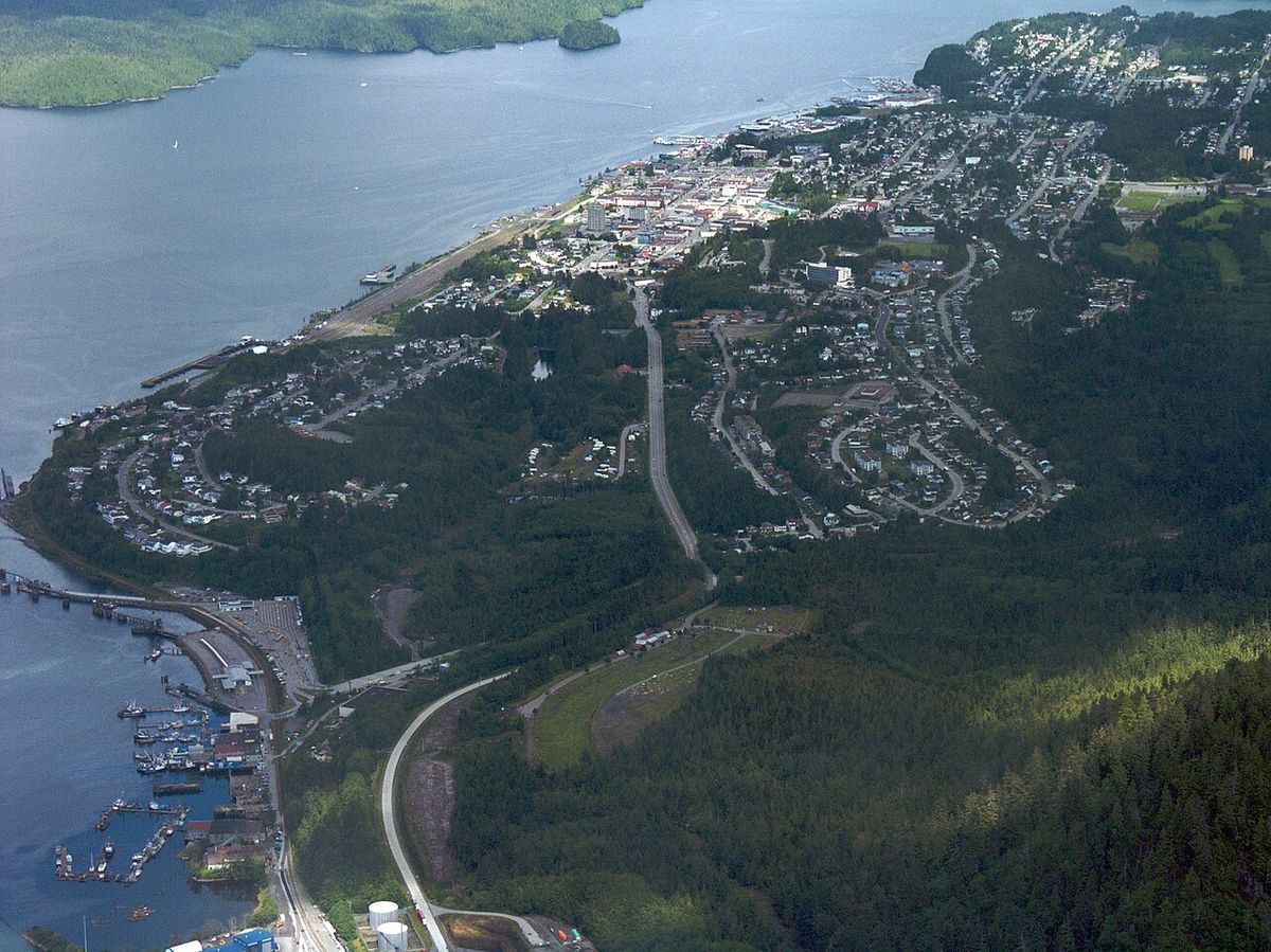
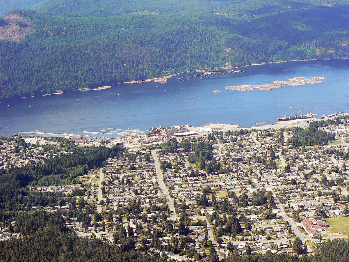
Port Alberni is situated at the head of the Alberni Inlet, Vancouver Island's longest inlet, which extends out to Barkley Sound and the Pacific Ocean, including the Broken Group Islands renowned for kayaking. The city lies within the Alberni Valley, surrounded by the snow-covered peaks of the Beaufort Range and mountains including Mount Arrowsmith, known as Kuth-kah-chulth in Nuu-chah-nulth, and Mount Klitsa. Key local water bodies include the Somass River, Sproat Lake located 10 kilometres west, and several creeks like Kitsuksis, Cherry, Roger, and Dry Creek that bisect the urban area and create natural barriers with hiking trails. The city's unique layout stems from its twin-city history, with the former Alberni now called North Port, centred at Highway 4 and Gertrude Street and marked by the historic Alberni Post Office, and the former Port Alberni known as South Port or Uptown, centred around 3rd Avenue and Argyle Street about 3 kilometres south.
Recent residential and commercial development has occurred primarily in the North Port area 'up the hill' east of the downtown and in the West End, where the Westporte neighbourhood has taken shape amid an eclectic mix of new homes and large acreages near two First Nations reserves. South Port is anchored by the Harbour Quay waterfront collection of shops, art galleries, and parks, and features the renovated Capitol Theatre, the Port Alberni railway station, the farmers' market, and the Maritime Discovery Centre. The city has a warm-summer Mediterranean climate (Köppen Csb) characterized by a dry July and wet winters from cool, moist Pacific air, making it one of the warmest places on Vancouver Island in summer with temperatures exceeding 30°C on 15 to 30 days a year. The highest temperature ever recorded was 42.7°C on June 28, 2021, and the coldest was -21.7°C on January 14, 1950, with the weak rain shadow from the island's mountains insufficient to keep the city dry during the winter months.
Demographics and Social Characteristics
According to the 2021 census, Port Alberni had a population of 18,259, living in 8,451 of its 8,919 total private dwellings, representing a 3.3% increase from its 2016 population of 17,678. The population density is 928.7 persons per square kilometre based on a land area of 19.66 square kilometres, and the median total household income in 2020 was $67,000. The demographic character of the city still reflects its twin-city origins, with two distinct commercial centres in North Port and South Port creating a recognizable community structure. In terms of religious affiliation, the 2021 census reported that 63.3% of the population (11,365 persons) identified as having no religious affiliation, while 32.2% (5,785 persons) identified as Christian.
Other religious groups in Port Alberni include Sikhism, with 215 persons or 1.2 percent of the population. Hinduism is followed by 125 persons or 0.7 percent, and Buddhism by 110 persons or 0.6 percent. Indigenous Spirituality is practiced by 85 persons or 0.5 percent, Islam by 70 persons or 0.4 percent, and Judaism by 30 persons or 0.2 percent. The city is the location of the head offices of the Alberni Clayoquot Regional District. Its West Coast General Hospital provides services to west coast communities like Bamfield, Tofino, and Ucluelet. Public education is offered by School District 70 Alberni, which operates 11 schools in Port Alberni. A new multimillion dollar state of the art high school opened in 2012 to 2013. The Conseil scolaire francophone de la Colombie Britannique operates one Francophone primary school, école des Grands cèdres.
Economy and Major Industries
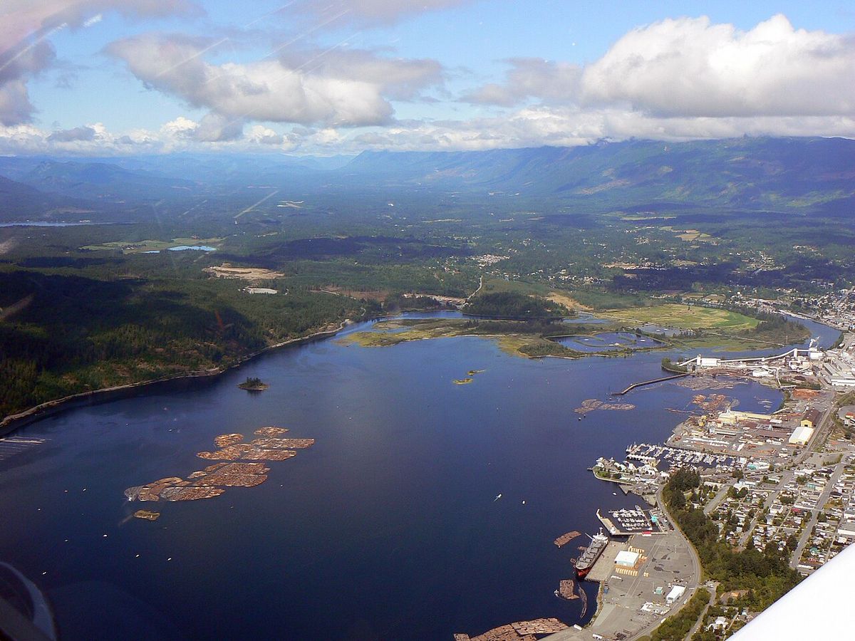
The economy of Port Alberni has historically been dominated by forestry, commercial fishing, and, increasingly, tourism. The valley's forests consist primarily of Douglas fir, hemlock, yellow cedar, and western red cedar, with most current logging coming from second-growth is most old-growth forests have been harvested. Major industrial facilities include the Port Alberni Mill, a kraft pulp mill opened in 1946 with paper machines added in 1957 and now owned by Catalyst Paper, which produces 340,000 tonnes of directory and lightweight coated paper annually, and the Alberni Pacific Division lumber mill on the inlet. Port Alberni serves as a hub for those travelling to the West Coast of Vancouver Island, including Ucluelet, Tofino and Pacific Rim National Park. As commodities tend to be much pricier in these remote areas, campers and travellers often do their shopping in Port Alberni before continuing their journey. This has resulted in development along the Johnston Road, or Highway 4, corridor, including several big box retailers, grocery stores and strip mall developments. Previously, eco tourism companies have set up shop in the Alberni Valley, taking advantage of the city's location on the fringe of wilderness yet proximate location to Vancouver and Victoria. For example, there is a kayaking, ATV touring, a windsurfing and a glider company.
- Forestry and wood products manufacturing from second-growth stands.
- Commercial fishing and salmon enhancement through local hatcheries.
- Tourism and outdoor recreation, including as a travel gateway.
- Agriculture practised in the valley's arable land.
- Retail and service sector supporting west coast travel logistics.
- Aviation and aerospace operations at Port Alberni Airport with key tenants like Coulson Aircrane.
- Port operations and marine cargo handling on the Alberni Inlet.
Attractions, Recreation and Sports
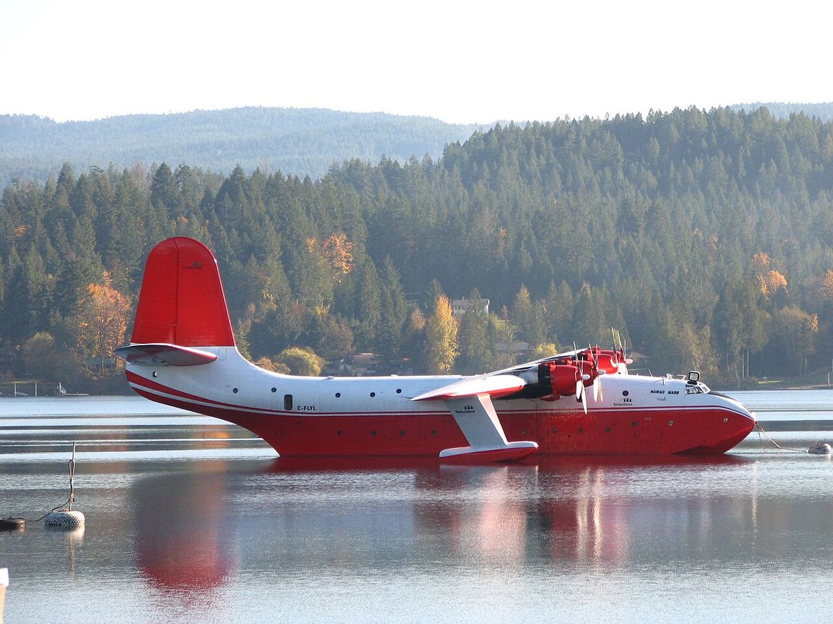
Port Alberni's location amidst mountains and waterways provides a wealth of outdoor attractions. The area is renowned for salmon fishing, with five species of salmon and yearly steelhead runs, earning it the World Fishing Network's 'Ultimate Fishing Town' designation in 2010 thanks to habitat work by volunteers and the Department of Fisheries and Oceans. The Robertson Creek Fish Hatchery on the Stamp River, the most successful on Vancouver Island producing chinook, coho, and steelhead smolts, is open to the public, as is a coho hatchery at the McLean Mill site. Hiking, mountain biking, and wildlife viewing for deer and black bears are popular in the surrounding mountains and along creek trails like those in Kitsuksis Creek ravine. Sproat Lake is a major summer destination for swimming, boating, and viewing the world's largest aerial firefighting flying boats, the Martin Mars Water Bombers, now the Coulson Flying Tankers, and features ancient First Nations petroglyphs.
Cultural and historic attractions include the McLean Mill National Historic Site, a steam-powered sawmill with an operating steam railway connection to the downtown harbour offering demonstrations. The Alberni Valley Museum and the renovated Capitol Theatre in South Port, a local landmark, host exhibits and live performances. The waterfront areas, Harbour Quay and Victoria Quay, feature shops, art galleries, and restaurants, with occasional black bear sightings foraging for fish at low tide on the inlet. The Alberni Valley Multiplex is home to the junior A hockey team, the Alberni Valley Bulldogs of the BCHL, and the city has a rich sporting history including the 1955 Canadian Senior Basketball Championship-winning Alberni Athletics, inducted into the BC Sports Hall of Fame in 2001. Della Falls, the 16th tallest waterfall in Canada at 442 metres, is accessible by boat from Great Central Lake or by helicopter, though landing is not permitted in Strathcona Provincial Park.
Transportation and Infrastructure
Port Alberni is a key service centre for central Vancouver Island with a developed transportation network. Highway 4, known locally as the Alberni Highway and the Pacific Rim Highway, is the main east-west route with a total length of 163 kilometres, completed to the city in 1942 and designated Highway 4 in 1953, connecting Qualicum Beach to Tofino and Ucluelet. The Port Alberni Airport (CBS8), located 11 kilometres northwest of the city, features a 4,000-foot runway with an additional 2,500 feet of taxiways and apron and is home to key tenants including Coulson Aircrane, Canadian Aero Technologies, the Alberni Valley Flying Club, and Vancouver Island Helicopters. The city is also served by the Island Rail Corridor branch line from Parksville known as the Port Alberni Subdivision, providing a freight rail link.
Public education is delivered by School District 70 Alberni across its 11 schools, while Francophone primary education is provided by école des Grands-cèdres. Health services are centred at the West Coast General Hospital, operated by Island Health, which serves Port Alberni and west coast communities like Bamfield and Tofino. The Port Alberni Port Authority manages port operations for the Alberni Inlet from the Somass River to Tzartus Island, overseeing cargo and marine traffic. The city's infrastructure supports its role as a government hub, being the location of the head offices of the Alberni-Clayoquot Regional District, and its development as a tourism destination continues with investments in local attractions and amenities.
Notable Residents and Cultural Figures
Port Alberni has been the birthplace or home to several notable Canadians across politics, arts, and sports. Kim Campbell, who served as the 19th Prime Minister of Canada from June 25 to November 4, 1993 and was the first woman to hold the office, is from the city. George Clutesi (1905 to 1988), a Tseshaht artist, actor, and writer, became a respected expert and spokesman for First Nations cultures, receiving the British Columbia Centennial Award in 1959 and the Canada Centennial Medal in 1967, and was commissioned to paint a mural for Expo 67. Television journalist Paul Boyd, known for Inside Edition, and Olympic wrestler Travis Cross are also from Port Alberni. The city's 1955 Canadian Senior Basketball Championship-winning team, the Alberni Athletics, was inducted into the BC Sports Hall of Fame in 2001, with famed sports broadcaster Jim Robson honing his skills doing play-by-play for their games on radio station CJAV.
Other significant individuals connected to the area's history include Captain Edward Stamp, for whom Stamp Falls and Stamp River are named, and Gilbert Sproat, who gave his name to Sproat Lake, both instrumental in the early sawmill industry. Jeremiah Rogers, head logger for Anderson, Anderson & Co., is commemorated in Rogers Creek flowing through the city centre. The legacy of early exploration is marked by Frances Barkley, the first European woman to visit British Columbia, whose name is borne by one of the vessels that travels the Alberni Inlet. These figures collectively represent the diverse historical threads of industry, exploration, and cultural achievement that define Port Alberni.
Questions about Port Alberni
What is Port Alberni known for?
Port Alberni is historically known for its forestry and commercial fishing industries, with its first sawmill built in 1861. It is renowned as a destination for salmon fishing, having been named the 'Ultimate Fishing Town' by the World Fishing Network in 2010. The city is also a gateway for tourism to Pacific Rim National Park and the west coast communities of Tofino and Ucluelet. Notable attractions include the McLean Mill National Historic Site with its steam railway, Sproat Lake, and the surrounding mountains for hiking and outdoor recreation.
What was the 1946 Vancouver Island earthquake?
The 1946 Vancouver Island earthquake was a 7.3 magnitude earthquake that struck at 10:15 a.m. on Sunday, June 23, 1946. The main shock epicentre occurred in the Forbidden Plateau area north of Port Alberni. The earthquake is remembered as one of the most damaging earthquakes in the history of British Columbia. Shaking was felt from Portland, Oregon to Prince Rupert, British Columbia.
What is there to do in Port Alberni?
Port Alberni sits beneath Mount Arrowsmith and is almost completely surrounded by mountains, which provide hiking, walking, and mountain biking trails. The city is also known for its fishing, as its waters contain five different species of salmon and yearly runs of steelhead. Attractions include the McLean Mill National Historic Site, which incorporates a steam railway, and the waterfront Harbour Quay, which has shops, art galleries, and restaurants. The world's largest aerial firefighting flying boats, the Martin Mars Water Bombers, once made their home on nearby Sproat Lake.
Where is Port Alberni located?
Port Alberni is a city located on Vancouver Island in the province of British Columbia, Canada. It lies within the Alberni Valley at the head of the Alberni Inlet, which is Vancouver Island's longest inlet. The city is almost completely surrounded by mountains, including the snow covered peaks of the Beaufort range, Mount Arrowsmith and Mount Klitsa. Port Alberni is adjacent to the natural harbour of the inlet as well as the Somass River. The city's unique layout is partly due to its history as a twin city, with two official city centres now known as North Port and South Port.
How did Port Alberni get its name?
The City of Port Alberni is named for Captain Don Pedro de Alberní, a Spanish officer who commanded Fort San Miguel at Nootka Sound from 1790 to 1792. The original settlement of Alberni developed around a sawmill in the 1860s. In 1896, a new settlement was established to the south, first known as New Alberni and later as Port Alberni, built around a Canadian Pacific Navigation Company wharf. The neighbouring towns of Alberni on the north and Port Alberni on the south amalgamated in 1967 to form the single city of Port Alberni. Many other local place names, such as Sproat Lake and Stamp River, are also named for historical figures.
Who are some famous people from Port Alberni?
Notable people from Port Alberni include Kim Campbell, who became the 19th Prime Minister of Canada and the first woman to hold that office. George Clutesi, a Tseshaht artist, actor, writer and cultural spokesman, received national recognition and was left art supplies by Emily Carr. The city also has a rich sporting history. The Alberni Athletics basketball team won the Canadian Senior Basketball Championship in 1955, an achievement that led to their induction into the BC Sports Hall of Fame in 2001. Sportscaster Jim Robson honed his skills doing play by play for the Athletics on radio station CJAV.
Sources: Wikipedia and current public reporting, checked by the Your Space Hamilton desk. Last updated 2026-11-01.