Fort St. John, British Columbia
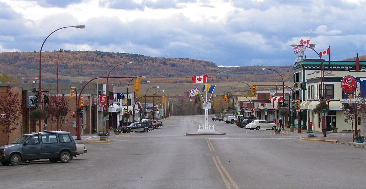
Fort St. John is a city in northeastern British Columbia and the most populous municipality in the Peace River Regional District. Established as a trading post in 1794, it is the oldest European-founded settlement in present-day British Columbia. Located at Mile 47 of the Alaska Highway, the city serves as a major retail, service, and industrial centre for the surrounding Peace River Country, with an economy historically driven by oil and gas, agriculture, and forestry. Recorded with a population of 21,465 in the 2021 census, Fort St. John is known regionally as "The Energetic City."
History
The area's first trading post, Rocky Mountain Fort, was established by the North West Company in 1794, one year after explorer Sir Alexander Mackenzie travelled through the region. That fort closed around 1805, and Fort St. John's was established a year later. Ownership transferred to the Hudson's Bay Company after the 1821 merger of the two fur trade rivals. The post operated until 1823, when it was closed following a violent incident where several Hudson's Bay Company employees were killed by a band of Northern Athapaskans, an event historian Shepard Krech III later characterized as an impromptu reaction to inflexible company trading policies. After a lapse of 37 years, Fort St. John was reopened in 1860, and the original site was designated a National Historic Site of Canada in 1958.
In 1925, Frank Worth Beaton relocated the settlement to Fish Creek, about 1.6 kilometres northwest of the current city. The community's modern growth was catalyzed by the Second World War, when it served as a station for the United States Army's 341st General Service Regiment during the construction of the Alaska Highway. The population grew to a few thousand people during construction but declined after the highway's completion. The first official census to recognize Fort St. John as a subdivision in 1951 recorded 884 residents. A subsequent oil and gas boom spurred rapid growth, with the population doubling nearly every five years for 15 years, reaching 6,749 by 1966. In May 1971, Queen Elizabeth II and Prince Philip, Duke of Edinburgh, visited the city and were greeted by an estimated crowd of 4,000 people.
Geography and Climate
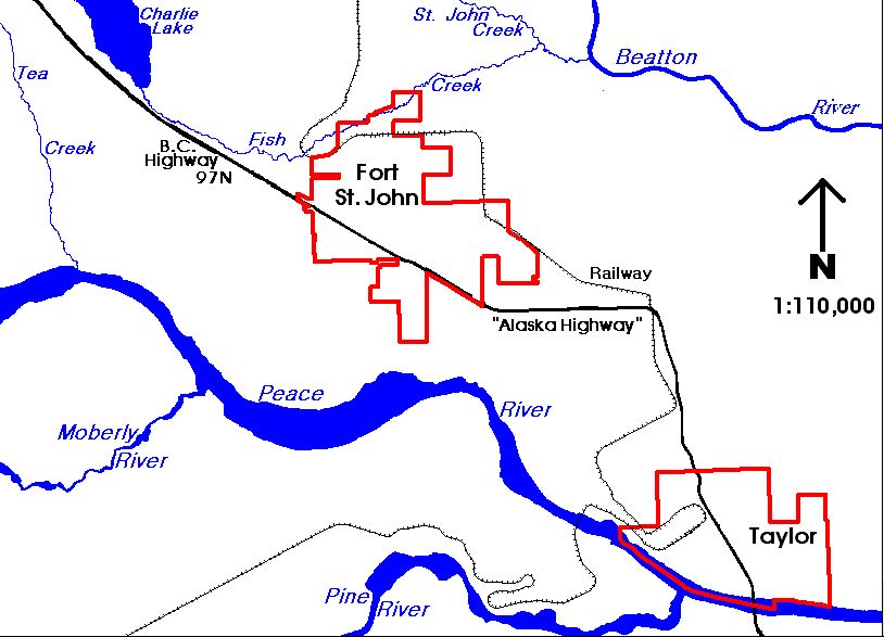
Fort St. John is geographically on the western edge of the Canadian prairies that cover much of Alberta, Saskatchewan, and Manitoba, though it is not politically part of those provinces. The city sits between the Peace River and Beatton River, with Charlie Lake nearby, within the broader Peace River Country region shared with Chetwynd, Tumbler Ridge, and Dawson Creek. The terrain consists of relatively flat, rolling hills at an elevation of 690 metres, positioned within a low-lying valley near the eastern foothills of the Muskwa and Hart Ranges of the Northern Rockies. This location east of the mountains creates a rain shadow effect, resulting in a climate more akin to the prairies than to the British Columbia interior west of the Rockies, and provides a long frost-free period suitable for farming crops like wheat and canola.
Fort St. John experiences a cold humid continental climate that closely borders on a subarctic climate, characterized by cold winters and warm summers. Winters are milder than much of Canada at a similar latitude due to the blocking influence of the Rocky Mountains on Arctic air masses coming from the north and northwest. The area is one of the sunniest in British Columbia, holding provincial sunshine records for March (247.4 hours in 1965), May (373.5 hours in 1972), and November (141.3 hours in 1976). A predominantly southwesterly wind blows through town, with average speeds around 14.0 kilometres per hour. The city observes Mountain Standard Time year-round, leading to very short daylight hours in winter and long hours in summer.
| Climate Record | Value | Date/Period |
|---|---|---|
| Coldest Temperature | -53.9 °C | 11 January 1911 |
| Warmest Temperature | 38.3 °C | 16 July 1941 |
| Warmest Month (Avg. Mean) | 19.2 °C | July 2024 |
| Record High Daily Minimum | 20.9 °C | 29 June 2021 |
| Record High Dew Point | 22.2 °C | 31 July 1960 |
| Most Humid Month (Avg. Dew Point) | 11.5 °C | August 2013 |
| Lowest Yearly Max Temperature | 25.0 °C | 1976 |
Demographics and Religion
According to the 2021 census, Fort St. John had a population of 21,465, living in 8,777 of its 10,004 total private dwellings. This represented an increase of 5.9 percent from its 2016 population of 20,260. With a land area of 32.67 square kilometres, the population density was 657.0 persons per square kilometre. The city serves as an urban centre for a wider rural and farming population of approximately 8,306 people and a total regional population of about 18,609. The demographic profile is relatively young, partly due to migration attracted by high-paying jobs in the resource sector, which contributes to a high workforce participation rate and a notable male-female income gap. The 2021 census provided a detailed breakdown of religious affiliations in the city, with the following groups represented.
- Irreligion: 12,170 persons (57.5%)
- Christianity: 7,685 persons (36.3%)
- Sikhism: 490 persons (2.3%)
- Hinduism: 290 persons (1.4%)
- Islam: 250 persons (1.2%)
- Indigenous Spirituality: 60 persons (0.3%)
- Buddhism: 50 persons (0.2%)
- Judaism: 20 persons (0.1%)
Economy and Infrastructure
Fort St. John functions as the primary retail, service, and industrial centre for northeastern British Columbia. The provincial oil and gas industry is centred in the city, home to the British Columbia Oil and Gas Commission. Forestry gained importance with the 2005 opening of an oriented strand board plant, with much of the product exported to the United States. The city also serves as a transportation and industrial hub for nearby BC Hydro hydroelectric facilities, including the W.A.C. Bennett Dam, Peace Canyon Dam, and Site C dam. A 2001 census snapshot showed 9,985 income-earners over age 15 in the city, with 4,500 of them working full-time throughout the year.
The city is a key transportation node for the region. Highway 97, the Alaska Highway built in 1942, runs through the city, connecting it north to Fort Nelson, the Yukon, and Alaska, and south to Dawson Creek. Within the city, streets are laid out in a grid with main arteries at 100 Street and 100 Avenue. A rail line, extended from Chetwynd by the Pacific Great Eastern Railway, arrived in 1958 and runs by the eastern and northern borders. The Fort St. John Airport, located a few miles east of the city, is the only commercial airport between Dawson Creek and Fort Nelson, served by airlines including Air Canada Jazz, WestJet, Central Mountain Air, and Swanberg Air, with North Cariboo Air providing charters. Intercity bus service is now provided by BC Bus North following Greyhound's cessation of Western Canada operations in 2018.
Municipal water is pumped from four deep wells near the Peace River with Charlie Lake as a backup source. It is filtered, chlorinated, and fluoridated, with fluoride added in 1963, and is rated as very hard by the BC Ministry of Environment. Sewage is processed in one of two lagoons, with the southern lagoon discharging into the Peace River and the northern lagoon into the Beatton River. Storm sewers discharge directly into the rivers without treatment. The city's fire department consists of volunteer and professional members covering the city and an eight-kilometre radius into rural areas.
Arts, Culture, and Recreation
As the main urban centre for approximately 20,000 people in the region, Fort St. John hosts many recreational and cultural facilities. Centennial Park is a central location featuring the Fort St. John North Peace Museum, the North Peace Leisure Pool, the North Peace Arena which is home to the Fort St. John Huskies hockey team, a separate children's arena, an eight-sheet curling rink, an outdoor water park, and a speed skating oval. Other significant parks include the city-maintained Fish Creek Community Forest and the nearby Beatton Provincial Park and Charlie Lake Provincial Park, about ten kilometres northwest of town. The North Peace Cultural Centre in the downtown core houses the Fort St. John Public Library, a theatre, and the Peace Gallery North art gallery.
The primary recreation complex is the Pomeroy Sport Centre, originally known as the Fort St. John Enerplex, which opened in 2010. The three-storey facility contains two NHL-sized ice rinks, 12 dressing rooms, a concession, public meeting rooms, a retail juice outlet, an indoor near-Olympic-sized long track speed skating oval, and a 340-metre walking track called the Northern Vac Track. All ice surfaces can be removed to provide over 140,000 square feet of event space. The facility also houses the Energetic Learning Campus, a satellite campus of North Peace Secondary School. The city has a history of hosting major multi-sport events, including the following games.
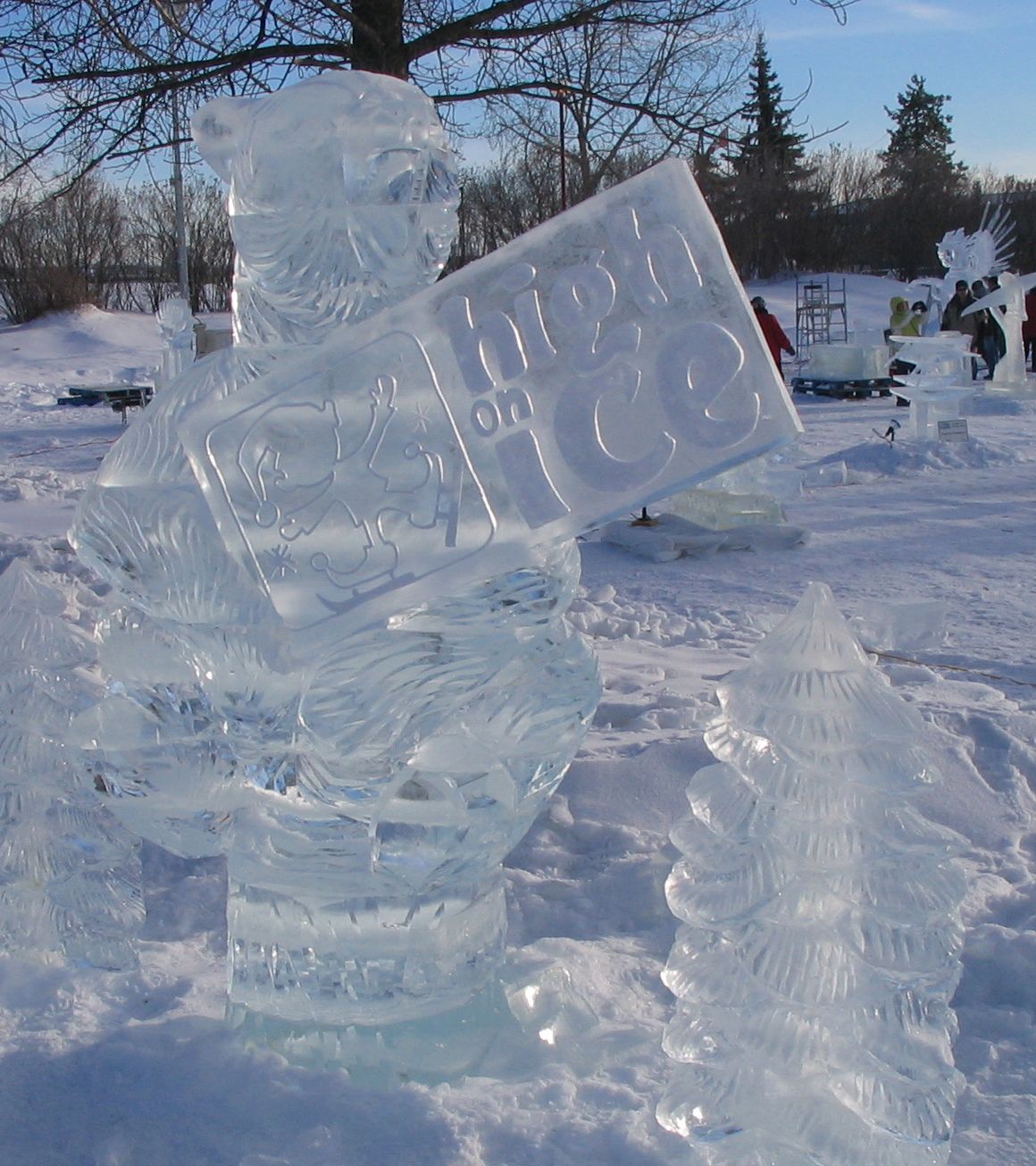
Annual community events in Fort St. John have included the Great Canadian Welding Competition. During this competition, welding artists fill Centennial Park creating statues on the year's given theme. Another major event is Winter Fest, held in February. This festival features a frozen Centennial Park filled with ice sculptures and ice slides. Winter Fest also includes other special winter-related activities occurring around town. Fort St. John has hosted the BC Winter Games in 1984 and 2020, and the Northern BC Winter Games on several occasions.
Government, Policing, and Education
Fort St. John operates under a council-manager form of municipal government. A mayor and six councillors are elected at-large every four years. In the 2022 election, Lilia Hansen was elected mayor, succeeding Lori Ackerman who had served since 2011. The mayor and one councillor represent the city on the Peace River Regional District board. Seven school board trustees for School District 60 Peace River North are also elected by residents. Provincially, the city is in the Peace River North electoral district, represented in the Legislative Assembly by Jordan Kealy, who replaced Pat Pimm. The district was long represented by Richard Neufeld, first elected in 1991 for the BC Social Credit Party with 56 percent support in Fort St. John polls, and later re-elected with Reform BC and the BC Liberals, serving as minister of Energy, Mines and Petroleum Resources from 2001. Federally, Fort St. John is part of the Prince George, Peace River riding, represented by Conservative MP Bob Zimmer, a former high school teacher and local resident. The riding was previously held by Jay Hill, born and raised in Fort St. John, who was first elected in 1993 and served as Government House Leader and Chief Government Whip.
Police protection in Fort St. John is contracted to the Royal Canadian Mounted Police. The RCMP operates a 26 officer municipal detachment and a 10 member rural detachment from the city. In 2005, the municipal detachment reported 4,048 Criminal Code offences. This translated into a crime rate of 228 offences per 1,000 people, which was much higher than the provincial average of 125 offences. During that year, compared to the provincial average, the RCMP reported much higher crime rates in Fort St. John for cocaine, cannabis, non sexual assaults, property damage, and arson related offences. However, the city had lower crime rates for robbery, theft from motor vehicles, and business break and enters.
The city is served by School District 60 Peace River North, which administers nine public schools within city limits, including one secondary school, and ten more outside the city. There is also one private Christian school in Fort St. John administered by the same district. Post-secondary education is available at the Fort St. John campus of Northern Lights College, which houses the B.C. Centre of Training Excellence in Oil and Gas, featuring a full-sized oil rig and simulated well site. A 2001 census estimate indicated that 10 percent of people aged 20 to 64 in Fort St. John were university graduates, less than half the provincial average of 24 percent, while 27 percent did not graduate from secondary school, seven percent higher than the provincial average. A 2023 survey showed C. M. Finch School had the highest academic performance in the city for the 2021/2022 school year with a rating of 7.5 out of ten, while Margaret Ma Murray Community School had the lowest with a rating of 4.2.
Media and Honours
The Alaska Highway News is published in Fort St. John. Digital news is provided by the EnergeticCity.ca website. Radio stations broadcasting from the city include 98.5 GO FM, which is CHRX FM playing adult contemporary music. Other stations are 101.5 FM The Goat, which is CKNL FM playing rock, and 92.5 Sunrise FM, which is CIAM FM with religious programming. The country music station is 100.1 Moose FM, which is CKFU FM.
The Freedom of the City award is the highest honour the municipality of Fort St. John can bestow. A number of individuals have received this award over the years. The most recent recipients were noted in the mid 2020s. The award represents a significant civic recognition.
- Charles "Bud" Hamilton: 7 December 1979
- William James "Jim" Eglinski: 24 June 2019
- Senator Richard Neufeld: 24 June 2019
- Jean Leahy: 9 September 2019
- Sue Popesku: 11 June 2022
- Steve Thorlakson: 15 July 2025
- Brian Surerus: 30 July 2026
The only military unit to receive the Freedom of the City award in Fort St. John is the 2276 Royal Canadian Army Cadets corps. This corps was honoured with the award on 10 April 2006. This recognition highlights the unit's service and connection to the community. The award remains a unique distinction for this cadet corps.
Questions about Fort St. John, British Columbia
Why is Fort St. John called "The Energetic City"?
The municipal slogan "Fort St. John: The Energetic City" reflects its dynamic economy and active community spirit. The name connects to its role as a hub for the oil and gas industry, agriculture, and forestry in northeastern British Columbia. It also references the city's numerous recreational facilities and events, such as the Pomeroy Sport Centre and the hosting of multiple BC Winter Games. The slogan is widely used in local promotion and civic identity.
What is the oldest building or site in Fort St. John?
The original site of Fort St. John's trading post, established in 1794, is the oldest European-founded settlement in present-day British Columbia. This site, located south of the modern city, was designated a National Historic Site of Canada in 1958. The trading post operated intermittently, closing in 1823 after a violent incident and reopening in 1860. While no original structures remain at the historic site, it commemorates the area's deep fur trade history.
What major industries support Fort St. John's economy?
Fort St. John's economy is supported by the oil and gas industry, which is centred in the city and includes the provincial Oil and Gas Commission. Forestry has become more important since the opening of an oriented strand board plant in 2005. The city is a retail, service and industrial centre for the surrounding rural and farming population. It also serves as a transportation hub and industrial centre for nearby hydro electric facilities like the W.A.C. Bennett Dam and Site C dam.
How do you get to Fort St. John?
Fort St. John is accessible by road, air, and rail. The primary route is Highway 97, the Alaska Highway, which runs directly through the city. The Fort St. John Airport offers commercial flights via carriers like Air Canada Jazz and WestJet, connecting to major centres. A rail line, extended to the city in 1958, runs along its eastern and northern borders. Intercity bus service is provided by BC Bus North to destinations such as Dawson Creek, Prince George, and Fort Nelson.
What are the main recreational facilities in Fort St. John?
The main recreational complex is the Pomeroy Sport Centre, a large facility with two ice rinks, an indoor speed skating oval, and a walking track. Centennial Park groups many amenities, including the North Peace Museum, a leisure pool, an arena, a curling rink, and outdoor features. The North Peace Cultural Centre houses the public library and an art gallery. The city also maintains the Fish Creek Community Forest and is near Beatton and Charlie Lake Provincial Parks for outdoor activities.
Who is the current mayor of Fort St. John?
As of the 2022 local government election, the mayor of Fort St. John is Lilia Hansen. She succeeded Lori Ackerman, who had served as mayor since 2011. The city government consists of the mayor and a six-member council, all elected at-large for four-year terms. The mayor and one councillor also represent Fort St. John on the board of the Peace River Regional District.
Sources and further reading
- Fort St. John, British Columbia (Wikipedia)
- Community and Culture (fortstjohn.ca)
- About Fort St. John (northernhealth.ca)
Checked by the Your Space Hamilton desk. Last updated 2026-11-02.