Dawson Creek
Dawson Creek is a city in northeastern British Columbia, Canada, with a land area of 24.37 square kilometres and a 2016 population of 12,978. It serves as the seat of the Peace River Regional District and is known as the "Mile 0 City" for its location at the southern terminus of the Alaska Highway. The city functions as a key service and transportation hub for the surrounding agricultural and resource-based region, often called the "Capital of the Peace". Its history transformed from a small farming settlement to a regional centre following the arrival of the Northern Alberta Railways in 1932 and the frenetic construction of the Alaska Highway by the US Army starting in 1942.
History and Development
The community's origins trace back to European-Canadian homesteaders in the Peace River Country, with the pace of settlement accelerating after the Canadian government began issuing land grants under the Dominion Lands Act in 1912. The arrival of the Northern Alberta Railways, which drove its golden spike on December 29, 1930, and saw its first passenger train arrive on January 15, 1931, established Dawson Creek as a western rail terminus and spurred its incorporation as a village in May 1936. A small wave of refugees from the Sudetenland settled in the area in 1939 as World War II began. The city's most dramatic period of growth began in 1942 when it became the staging ground for the United States Army's construction of the Alaska Highway, drawing thousands of personnel and transforming the local economy. A catastrophic fire and explosion in a livery barn packed with dynamite in February 1943 killed five people and injured 150, causing significant damage to the town centre. Dawson Creek also served as a Royal Canadian Air Force station from September 1944 until March 1946. Post-war development continued with new transportation links like the John Hart Highway in 1952 and the Pacific Great Eastern Railway extension from Prince George in 1958, the same year Dawson Creek was re-incorporated as a city. The RCAF station was re-established in October 1956, declared functional in 1958, and was disbanded for the final time in March 1964. Population growth peaked in 1966, and while the city's own numbers stabilized, the surrounding area has continued to grow. Since 1992, the city has undertaken several boundary expansions to incorporate industrial land, including a site for a Louisiana-Pacific Canada veneer factory in the southeast that was abandoned half-built and later completed as a manufactured home plant in 2005. Another expansion incorporated an existing oriented strand board factory in the city's northwest corner.
Geography and Climate
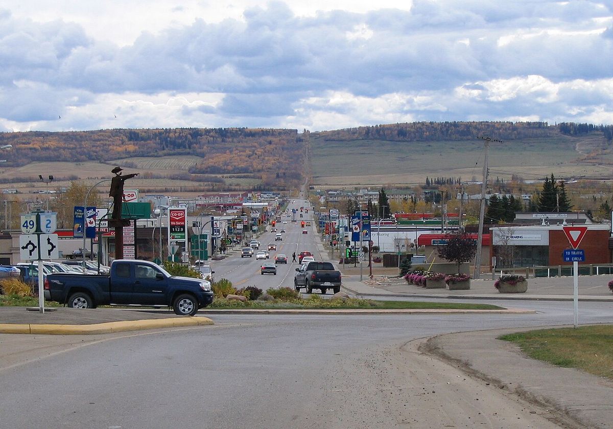
Dawson Creek is situated on the flat Pouce Coupe Prairie at the foot of Bear Mountain ridge, 72 kilometres southeast of Fort St. John and 134 kilometres northwest of Grande Prairie, Alberta. The city developed around the Dawson Creek watercourse, which flows east into the Pouce Coupe River, and is located in the British Columbia Peace Lowland ecosection of the Canadian Boreal Plains ecozone. According to the Canada Land Inventory, the city sits on soil with moderate limitations for crop range due to an adverse climate, requiring moderate conservation practices. The region lies within the Cordillera Climatic Region and experiences a subarctic climate that borders on a warm-summer humid continental climate, with very cold, dry winters and short, warm summers. The city averages 17 to 18 days per year with lows at or below -30°C and sees highs of 30°C only about twice annually. It is subject to strong winds year-round and uses Mountain Standard Time all year, never observing daylight saving changes. Precipitation peaks in July due to thunderstorm activity, and winter is the longest season, typically lasting from late October to early April. Record temperatures include a high of 38.9°C set on June 29, 2021, which also saw the record high daily minimum of 18.9°C. The warmest month on record was August 1981 with a mean temperature of 20.1°C, while August 2022 set the record for the highest average monthly daily maximum of 26.6°C. A freeze has been recorded in every month of the year, including the summer months, which are typically only two to three months long from June through August.
Demographics
According to the 2021 census, Dawson Creek had a population of 12,323 living in 5,405 of its 6,189 total private dwellings, representing a slight increase from 12,178 in 2016. The city's population history shows rapid growth mid-century, peaking at 12,392 in 1966 before declining throughout the 1970s and rising again briefly during the early 1980s construction of Tumbler Ridge. The 2016 census indicated a median age of 34.4 years, down from 38.8 years in 2001, with 53% of adults married or in common-law relationships, below the provincial average of 58%. Educational attainment also lagged slightly behind provincial rates, with 46% of residents over 15 holding a post-secondary certificate compared to 55% provincewide, and 17% of those aged 25-64 lacking a high school certificate, higher than the 10% provincial rate. The ethnic composition is diverse, with nearly 16% of the population identifying as Aboriginal (Métis or First Nations) and an additional 10% belonging to a visible minority group, primarily Filipino and South Asian. Religious affiliation in 2021 was predominantly non-religious, with 59.4% reporting no religion, while Christianity accounted for 36.3% of the population. Other religious groups present include Sikhism, Hinduism, Buddhism, Islam, Judaism, and Indigenous Spirituality.
- Irreligion: 7,170 persons (59.4%)
- Christianity: 4,385 persons (36.3%)
- Sikhism: 205 persons (1.7%)
- Hinduism: 80 persons (0.7%)
- Buddhism: 45 persons (0.4%)
- Islam: 40 persons (0.3%)
- Judaism: 10 persons (0.1%)
- Indigenous Spirituality: 10 persons (0.1%)
Economy and Major Industries
The local economy rests on four pillars: agriculture, retail, tourism, and oil and gas. Agriculture remains historically vital, with the city acting as a regional transshipment point for commodities from the surrounding Agricultural Land Reserve, which produces grains like canola, wheat, oats, and crops such as hay, alfalfa, and sweet clover. The retail and service sector caters to the city and outlying rural communities, though significant consumer spending leaks to Grande Prairie, Alberta, due to British Columbia's 7% provincial sales tax, a problem exacerbated by the introduction of large-format retail stores. In 2006, the provincial government rejected a proposal to lower the sales tax in border communities to 4% to combat this leakage. Tourism is anchored by the city's status as Mile 0 of the Alaska Highway, attracting thousands of travellers annually, particularly those in recreational vehicles which sometimes gather in convoys. The winter hospitality industry also caters to workers from nearby oil patches. Oil and gas activity, spurred by discoveries south of the city and higher energy prices, has created economic spillover from the larger industrial base in Fort St. John. A landmark development was the construction of British Columbia's first wind farm, the Bear Mountain Wind Park, southwest of the city in 2009.
Transportation and Infrastructure
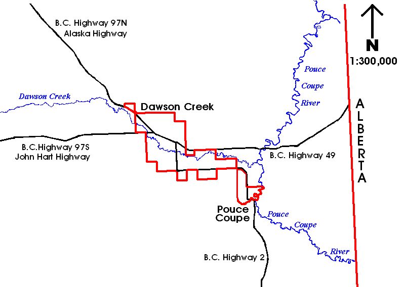
The city's road network was laid out in a mid-20th century grid and now includes 88 kilometres of paved and 11 kilometres of unpaved roads maintained by the city. Major traffic flow is concentrated on two arterial roads: 8 Street (north-south) and Alaska Avenue (southeast-northwest), which meet at a traffic circle that traditionally marked the start of the Alaska Highway. The Mile Zero Post has been relocated from this circle to the historic downtown area, one block south of the Northern Alberta Railways Park. Dawson Creek is a major highway junction, with the Alaska Highway (BC 97) running north to Fort St. John and the Yukon, the John Hart Highway (BC 97) connecting southwest to Chetwynd and Prince George, Highway 2 heading south to Grande Prairie, Alberta, and Highway 49 travelling east to Peace River, Alberta. A designated dangerous goods route along the southern and western borders, incorporating a stretch of Highway 2, allows heavy trucks to bypass the city centre, though trucks using Highway 49 must still travel through city arterials, slowing traffic and damaging roads. The Dawson Creek Airport was built in 1963 with its runway paved in 1966, but as of 2026, it has no scheduled commercial airline service, with the most recent service provided by WestJet. Passenger rail service was available from 1931 until 1974, first via the Northern Alberta Railways and later extended to Vancouver in 1958, before ending as commodity shipments of grain, oil and gas by-products, and forestry products became more important. The city draws its water supply from the Kiskatinaw River, treating it at a plant 18 kilometres west of town after pumping it through a settling pond and two storage ponds where it is flocculated, filtered, and chlorinated, and also provides water to Pouce Coupe and rural residents. Sewage is processed in lagoon systems east of the city before release into the Pouce Coupe River.
Education
Public education in Dawson Creek is managed by School District 59 Peace River South, which operates four elementary schools and one high school, Dawson Creek Secondary School. Private education options include Mountain Christian School, a K-12 institution operating on two campuses after purchasing the former Parkhill Elementary School in 2012 and the former Ron Pettigrew School in 2022. Notre Dame School provides Catholic education for students from kindergarten to grade 7. Post-secondary education is offered at the Dawson Creek campus of Northern Lights College, established in 1975, which houses the college's regional administration and two Centres of Excellence, and offers certificates, diplomas, associate degrees, and academic upgrading courses. The Ron Pettigrew Christian School, a K-12 institution affiliated with the Association of Christian Schools International, closed permanently in 2019. The city's educational infrastructure supports a range of learning needs from early childhood through to adult education and trades training.
- Public Elementary Schools: Tremblay, Frank Ross, Crescent Park, Canalta
- Public High School: Dawson Creek Secondary School
- Private K-12 School: Mountain Christian School (Alpha & Omega Campuses)
- Catholic School: Notre Dame School (K-7)
- Post-Secondary: Northern Lights College campus (Regional Administration, Centres of Excellence)
Culture, Recreation, and Landmarks
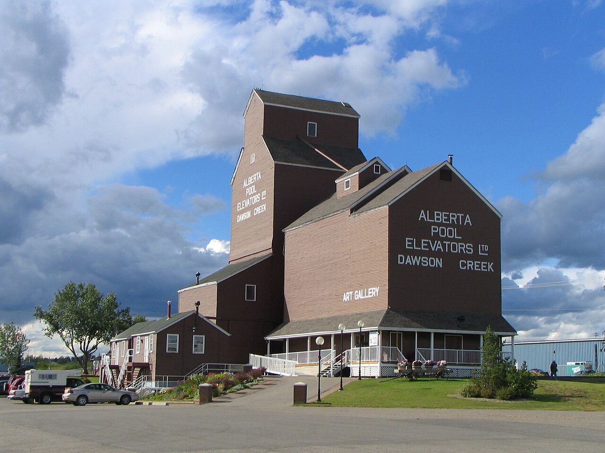
The city's cultural identity is intrinsically linked to the Alaska Highway, celebrated by the Mile 0 post which is depicted on the city flag. The four-acre Northern Alberta Railways Park, mostly paved, serves as a primary gathering point for travellers and houses the Dawson Creek Art Gallery, which exhibits work by local artists and craftsmen. One of the historic wooden grain elevators from the former "Elevator Row", taken out of service in the 1970s, has been preserved and converted into an art gallery. Annual events include a fall fair and rodeo, contributing to community life. The city also features a heritage interpretation village and a museum that detail the area's pioneering and highway construction history. The provincial government moved its regional offices from Pouce Coupe to Dawson Creek in the 1970s, and the Dawson Creek Mall was constructed during that decade, further establishing the city's role as a regional centre.
Population Trends
The city's population has shown significant shifts throughout its history, closely tied to major transportation projects and regional economic development. The first census to include Dawson Creek in 1941 counted 518 residents. Its growth spurred by the construction of the Alaska Highway, the town recorded a sevenfold increase to 3,589 residents in the 1951 census. Within five years, the population more than doubled to 7,531. New transport links with southern British Columbia and Alberta spurred continued growth into the next decade, and the population more than tripled between 1951 and 1961.
| Year | Population | Notes |
|---|---|---|
| 1941 | 518 | First census as a defined subdivision |
| 1951 | 3,589 | Post-Alaska Highway construction boom, a sevenfold increase |
| 1956 | 7,531 | More than double the 1951 count |
| 1966 | 12,392 | All-time population peak |
| 2005 | 10,869 | Provincial estimate |
| 2009 | 11,514 | Provincial estimate |
| 2016 | 12,178 | Official census count. Average household size 2.3 persons |
| 2021 | 12,323 | Official census count. 5,405 of 6,189 private dwellings occupied |
Notable Climate Records
Dawson Creek's climate station has recorded several notable extremes and averages that define its subarctic conditions. The record highest dew point was 22.4°C recorded on June 30, 2021, while the most humid month was August 1989 with an average dew point of 11.4°C. The record for the highest average monthly daily minimum temperature is 11.2°C, set in July 2024, and July 2020 held a record with no temperature below 0°C and no dew point below 5.2°C for the entire month. In contrast, the lowest yearly maximum temperature recorded was 25.6°C in 1976, and the lowest yearly maximum daily minimum was 12.2°C in 1974. The lowest yearly maximum dew point was 14.0°C recorded in 2003. The average yearly maximum dew point is 17.1°C and the average yearly maximum daily minimum temperature is 15.3°C. These records, along with the fact that August 1998 set a record with no maximum temperature below 19.2°C for the entire month, illustrate the variability and specific character of the local climate, which includes the potential for a freeze in any month.
Questions about Dawson Creek
Why is Dawson Creek called Mile 0?
Dawson Creek is called Mile 0 because it is the official southern terminus of the Alaska Highway. The highway's distance markers begin at zero in the city, a designation that has become central to the community's identity and tourism industry. The Mile 0 post is a major landmark, originally located at a downtown traffic circle and now situated in the historic downtown area. This status dates back to 1942 when the United States Army used the city's rail terminus as the starting point for constructing the highway to Alaska.
What is the population of Dawson Creek?
According to the 2021 Canadian census, the population of Dawson Creek was 12,323 people. This represents a slight increase from the 2016 census count of 12,178. The city's population peaked in 1966 at 12,392 and declined through the 1970s before stabilizing. Recent decades have seen relatively stable population numbers, with provincial estimates showing growth from 10,869 in 2005 to 11,514 in 2009 prior to the 2016 census.
What is the climate like in Dawson Creek?
Dawson Creek has a subarctic climate characterized by very cold, dry winters and short, warm summers. Winters are among the coldest in British Columbia, with temperatures dropping to -30°C on average 17 to 18 days per year. Summers are warm but brief, with daytime highs reaching 30°C only about twice a year on average. The area is known for being windy year-round. The city does not observe daylight saving time, using Mountain Standard Time throughout the year.
What are the main industries in Dawson Creek?
The main industries in Dawson Creek are agriculture, retail, tourism, and oil and gas. Agriculture has been historically fundamental, with the city serving as a transshipment hub for the surrounding farmlands. Retail serves the city and rural communities, though some business leaks to Alberta. Tourism is driven by the city's status as the start of the Alaska Highway. Oil and gas activity, concentrated south of the city, also contributes significantly to the local economy, with spillover effects from the larger industrial base in Fort St. John.
How do I get to Dawson Creek?
Dawson Creek is accessible primarily by road, as it is a major highway junction. The Alaska Highway (BC 97) runs north from the city, the John Hart Highway (BC 97) connects to the southwest, Highway 2 goes south to Grande Prairie, Alberta, and Highway 49 travels east. The Dawson Creek Airport exists but, as of 2026, has no scheduled commercial passenger service. The closest airports with regular flights are in Fort St. John, British Columbia, and Grande Prairie, Alberta.
Are there any universities or colleges in Dawson Creek?
Yes, Dawson Creek is home to a campus of Northern Lights College. Established in 1975, the college has a campus in Dawson Creek that houses its Regional Administration and two Centres of Excellence. At this campus, students can earn a one year certificate, a two year diploma or associate degree, or complete upgrading courses to obtain their high school diploma. The city does not have a university, but the college provides post secondary education for the region. The campus was part of the city's development in the 1970s when the provincial government also moved its regional offices there.
Sources and further reading
- Dawson Creek (Wikipedia)
- Dawson Creek on the Alcan Highway (bellsalaska.com)
Checked by the Your Space Hamilton desk. Last updated 2026-10-31.