Mount Garibaldi
Mount Garibaldi, known as Nch'ḵay̓ in the Squamish language, is a dormant stratovolcano in the Garibaldi Ranges of southwestern British Columbia. With a summit elevation of 2,678 metres, it is the centrepiece of Garibaldi Provincial Park, located approximately 64 kilometres north of Vancouver. The mountain is a product of complex volcanic activity spanning hundreds of thousands of years and is a significant landmark for Indigenous peoples, recreation, and geological study. Its dramatic landscapes, including glaciers, alpine lakes, and lava flows, make it a premier year-round destination for hikers, climbers, and outdoor enthusiasts.
Geography and Natural Setting
Mount Garibaldi is situated on the east side of the Cheakamus River, between the communities of Squamish and Whistler in the New Westminster Land District. It lies within the Eastern Pacific Ranges Ecosection, a subdivision of the Pacific Ranges Ecoregion characterized by rugged mountains of granitic rock, a transitional climate, and diverse ecosystems. The area experiences a mix of coastal maritime and interior continental influences, resulting in mild temperatures, significant winter snowfall, and cold Arctic air invasions that bring extreme cloud cover. The valleys and lower slopes are dominated by coastal western hemlock forests, which give way to subalpine mountain hemlock, Engelmann spruce, and subalpine fir forests at higher elevations. The alpine zone above the treeline consists largely of barren rock and ice, supporting wildlife including grey jays, Columbian black-tailed deer, mountain goats, wolverines, cougars, and both grizzly and black bears.
The northern and eastern flanks of the mountain are largely obscured by the Garibaldi Névé, a substantial snowfield covering about 30 square kilometres. Several named outlet glaciers radiate from this névé, including the Garibaldi, North Pitt, South Pitt, Lava, Sentinel, Warren, Bishop, Phoenix, and Pike glaciers. A 2009 study published in Global and Planetary Change found these glaciers have been progressively retreating since the early 1900s, and a 2015 University of British Columbia study suggested 70% of Canada's glacial ice could melt by 2100. The steep western face of Mount Garibaldi is the source of the Cheekye River, which drains a 60-square-kilometre catchment and is a tributary of the Cheakamus River. Other significant hydrological features include Ring Creek, which originates from the Bishop and Diamond glaciers, and the Pitt River, which begins at the North and South Pitt glaciers and flows into the Fraser River.
Geological Formation and Volcanic History
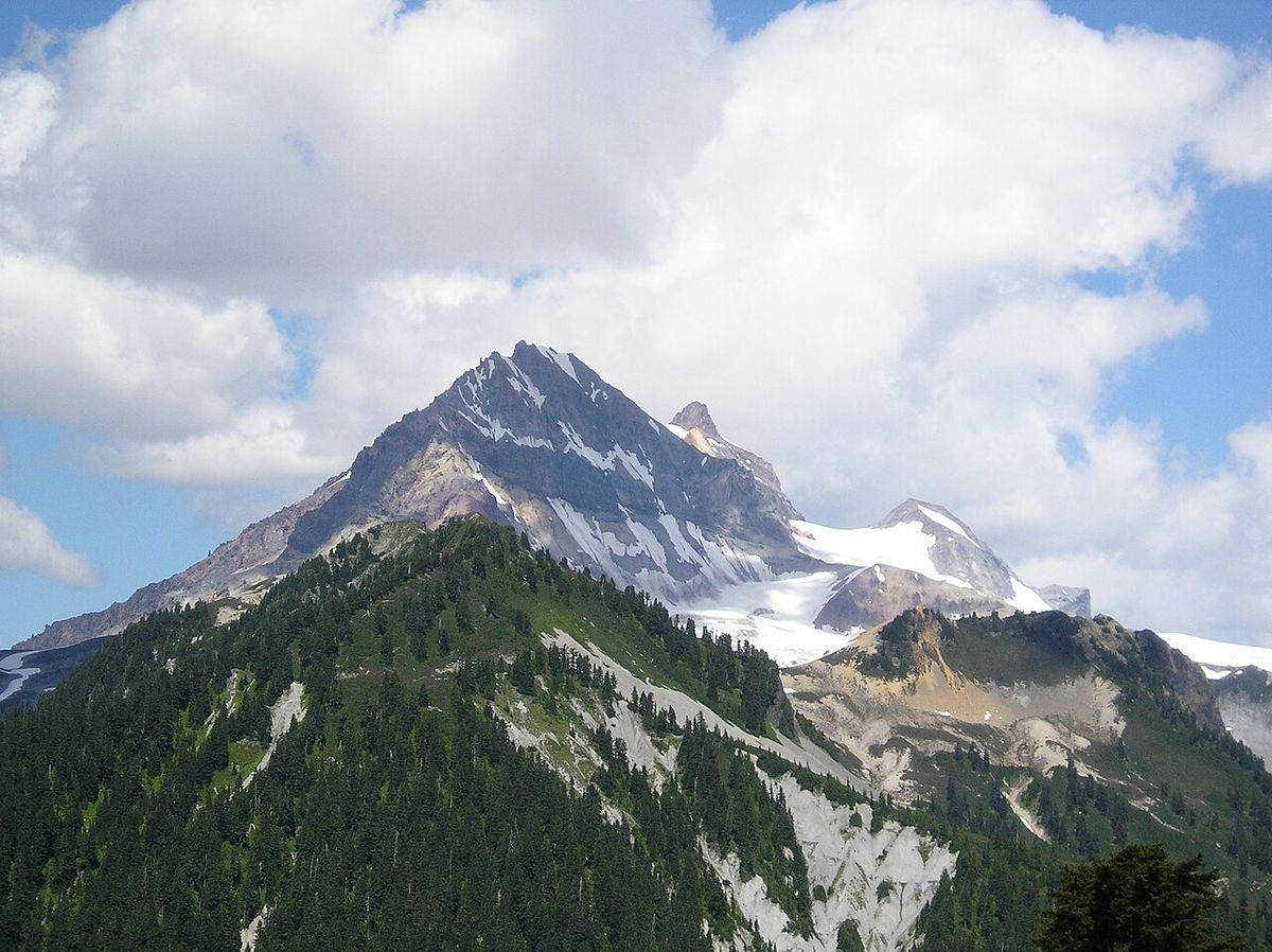
Mount Garibaldi is one of the three principal volcanoes in the southern Garibaldi Volcanic Belt, alongside Mount Price and The Black Tusk, and is part of the Cascade Arc. It is a stratovolcano composed primarily of dacite, with subordinate andesite and unique high-silica rhyolite, and is one of only three Cascade Arc volcanoes made exclusively of dacite. The total volume of volcanic rock in the combined Mount Garibaldi-Garibaldi Lake volcanic field is 26 cubic kilometres, with Mount Garibaldi itself comprising an estimated 16 to 20 cubic kilometres. The mountain's structure was heavily influenced by glacial ice, with a significant portion of its modern 6.5-cubic-kilometre edifice constructed over ice during the Pleistocene, classifying it as a supraglacial volcano. A distinctive 600-metre-high scarp on its western flank exposes the volcano's internal structure, formed by a catastrophic collapse between 12,800 and 11,500 years ago that produced the 25-square-kilometre Cheekye Fan debris flow deposit.
The volcanic history of Mount Garibaldi spans approximately 260,000 years and is divided into three main stages. The initial Cheekye stage, from 260,000 to 220,000 years ago, built a broad composite cone known as the ancestral or proto-Garibaldi volcano from dacite and breccia, with remnants exposed on Brohm Ridge and the mountain's lower flanks. After a long dormancy where the Cheekye River cut a valley later filled by the Fraser ice sheet, the Atwell Peak stage began around 13,000 years ago during the last glacial period. The eruption of the Atwell Peak plug dome from a ridge surrounded by ice generated pyroclastic flows and talus avalanches, forming a fragmental cone. The subsequent melting of supporting glacial ice triggered massive landslides on the western flank between 12,800 and 11,500 years ago, moving nearly half the volcano's volume into the Squamish Valley. The final Dalton Dome stage commenced as the ice sheet retreated, with eruptions from Dalton Dome and Opal Cone producing dacite lava flows, including the lengthy Ring Creek lava flow approximately 10,700 to 9,300 years ago, which is the last known eruptive event.
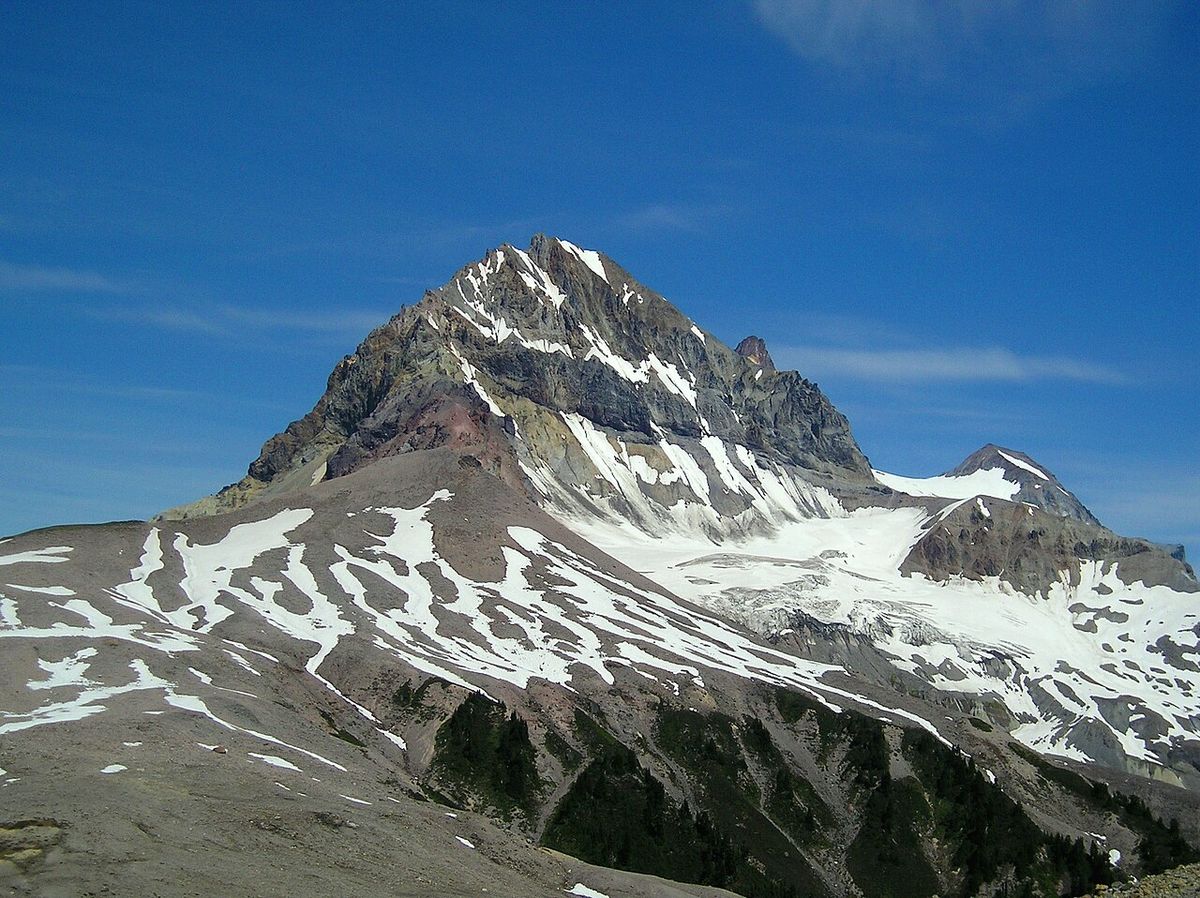
Key Geological Features- Atwell Peak: A sharp, conical plug dome with an elevation of 2,620 metres, prone to avalanching.
- Dalton Dome: A blunt summit reaching 2,633 metres on the northern flank.
- Opal Cone: A 1,740-metre parasitic cone on the southeastern flank, source of the Ring Creek lava flow.
- Garibaldi Névé: A 30 km² snowfield feeding multiple outlet glaciers like the Lava and Warren glaciers.
- Ring Creek Lava Flow: A roughly 15-kilometre-long dacitic flow with well-defined levees.
- Cheekye Fan: A 25 km² debris flow deposit from ancient flank collapses that once dammed Howe Sound.
- The Sharkfin: A rock spur separating the Warren and North Pitt glaciers.
- The Tent: A peak on the eastern side of the mountain.
Although considered dormant, Mount Garibaldi is classified by Natural Resources Canada as a very high threat volcano, the only other in Canada being Mount Meager. At least three seismic events have been recorded since 1985, indicating an active magmatic system. The area lacks hot springs, but evidence of anomalously high heat flow exists in locations like Table Meadows. Significant debris flows occurred in the 1930s and 1950s, with the 1950s flow reaching the Cheakamus River and forming a temporary 5-metre-high landslide dam.
Human History and Naming
The area surrounding Mount Garibaldi has been part of Squamish Nation territory for thousands of years. The mountain is known as Nch'ḵay̓ to the Squamish people, who have used the area for ceremonies and as a source of obsidian, and their oral histories include stories connecting the mountain to a great flood. The non-Indigenous name was assigned in 1860 by Captain George Henry Richards of the Royal Navy's Hydrographic Service, who named it in honour of Giuseppe Garibaldi, the Italian patriot and soldier. The first recorded ascent of the mountain was achieved in 1907 by a party led by mountaineer Atwell Duncan Francis Joseph King, for whom Atwell Peak is named. Another member of that party, Arthur Tinniswood Dalton, a Vancouver architect and city assessor, is commemorated by Dalton Dome.
Human interaction with the mountain has included both tragedy and development plans. In 1953, a Pacific Western Airlines plane crashed on its slopes, killing all five people aboard. A project to construct a ski resort began in the late 1960s but was halted in 1969 due to financial difficulties. Today, the mountain is fully protected within Garibaldi Provincial Park, which was established to preserve the region's natural and cultural values. The park encompasses 1,950 square kilometres of the Coast Mountains and is collaboratively managed, acknowledging the rights and interests of Indigenous Peoples including the Squamish Nation, Lil’wat Nation, and N’Quatqua. The southwestern amendment proposal for the park seeks to expand the trail and hut network in that area.
Garibaldi Provincial Park and Recreation
Mount Garibaldi is the central feature of Garibaldi Provincial Park, a 1,950-square-kilometre wilderness area established to protect the natural beauty and ecological values of the region. The park is a favourite year-round destination, offering over 90 kilometres of established hiking trails through terrain that includes snow-capped mountains, iridescent waters, and abundant wildlife. Primary access is via five trailheads along Highway 99 between Squamish and Pemberton, with the most popular being Diamond Head, Rubble Creek, and Cheakamus, each located 2 to 16 kilometres off the highway. To manage high visitation and protect the environment, BC Parks requires a free day-use vehicle pass for summer access at these trailheads, a program introduced in 2020 to reduce congestion and ecological damage from a 52% increase in visits since 2010.
For the 2026 season, passes are required at Diamond Head and Rubble Creek from Friday to Monday and holidays from June 12 to October 12. Passes are required daily at the Cheakamus trailhead from June 13 to September 7, and then Friday to Monday from September 8 to October 12. Passes are released online at 7 a.m. Pacific Time two days prior to a visit, and a maximum of four passes can be booked per reservation, with children under 12 free when accompanied by an adult. Visitors with valid overnight camping reservations do not need a day-use pass. The park's extensive trail network leads to renowned destinations like Garibaldi Lake, the Black Tusk, Panorama Ridge, and Elfin Lakes, which provide opportunities for hiking, camping, photography, and mountaineering. The main hiking season runs from July through September, while the winter months from November to April attract backcountry skiers, snowshoers, and ski mountaineers, with chains and four-wheel drive required for winter road access.
Permitted Recreational Activities- Hiking: On over 90 km of designated trails, including multi-day routes to Garibaldi Lake (18 km roundtrip) and Elfin Lakes (22 km roundtrip).
- Camping: At backcountry campgrounds like Garibaldi Lake and Elfin Lakes, and in the 33-person Elfin Lakes Shelter which has a propane stove and costs $15 per person nightly.
- Swimming: In designated lakes including Garibaldi Lake, Cheakamus Lake, Elfin Lakes, Russet Lake, Wedgemount Lake, and Glacier Lake.
- Canoeing and Kayaking: Permitted only on Cheakamus Lake, Garibaldi Lake, and Glacier Lake. Craft cannot be stored in the park.
- Fishing: Available at many lakes like Garibaldi and Mamquam lakes, requiring a provincial fishing licence.
- Cycling: Class 1 e-bikes and regular bicycles are allowed on the Diamond Head and Cheakamus Lake trails only. Helmets are mandatory.
- Mountaineering: On peaks like Mount Garibaldi, The Black Tusk, and Atwell Peak, involving glacier travel and technical routes.
- Skiing and Snowshoeing: Across vast backcountry terrain accessible from Diamond Head and ski lifts at Whistler Blackcomb.
Visitors to the area are urged to stay on designated trails to prevent erosion. They should also obey all signage for their safety and the protection of the environment. Practicing Leave No Trace principles is important to preserve the natural state of the region. Voluntary flight guidelines with designated no flight and minimum altitude pathways are also in place. These guidelines aim to minimize negative interactions between wildlife, people, and aircraft in the mountainous terrain.
Climbing Routes and Hazards
Mount Garibaldi presents a significant mountaineering objective, with routes of varying difficulty that require technical skill and knowledge of alpine hazards. The standard climbing routes typically involve traversing glaciers, ascending snow slopes, or climbing loose rock, with primary access via hiking trails from Alice Ridge, Brohm Ridge, and the Diamond Head parking lot at the end of Garibaldi Park Road. The mountain's two main sub-peaks, Atwell Peak and Dalton Dome, are also climbed, with Atwell Peak offering a particularly sharp and challenging conical summit with exposed ridges. The first ascent team in 1907 approached from the north via Brohm Ridge, and the mountain's steep western face provides a dramatic 1,300-metre proximal relief above the surrounding landscape. Climbers must be prepared for serious hazards inherent to the alpine environment, including hidden crevasses in glaciers like the Garibaldi and Warren glaciers, the risk of avalanches on snow slopes, and rockfalls from the mountain's unstable faces, particularly on the steep and loose western scarp and the faces of Atwell Peak.
Proper equipment such as ropes, helmets, ice axes, crampons, and crevasse rescue gear is essential for any ascent. Given the volcano's dormant status and seismic activity, climbers should also be aware of the potential, though remote, for volcanic unrest. All climbers are encouraged to check current conditions, obtain necessary park access permits, and ideally travel with experienced guides or within organized groups familiar with the Garibaldi Ranges. The mountain's classification as a very high threat volcano by Natural Resources Canada shows the importance of preparedness for both alpine and potential volcanic hazards.
Conservation and Park Management
The management of Garibaldi Provincial Park focuses on balancing recreational access with the preservation of its ecological integrity and cultural values. BC Parks, in collaboration with First Nations including the Squamish Nation, Lil’wat Nation, and N’Quatqua, oversees the park's operations through models like the joint technical working group for Pipi7íyekw/Joffre Lakes Park. A key management tool is the day-use pass system, introduced to reduce congestion on trails and at parking areas, minimize environmental damage from overuse such as trail damage and vegetation trampling, and enhance the visitor experience. The system has been in effect since 2020 in response to a 52% increase in visits to south coast BC Parks since 2010, and passes are free and reserved online two days prior to a visit.
Conservation efforts are guided by the need to protect sensitive alpine vegetation, prevent soil erosion, and minimize wildlife displacement from species like grizzly bears and mountain goats. The park's vast terrain includes critical habitat, and the voluntary flight guidelines for aircraft are part of these efforts, establishing no-flight zones and minimum altitude pathways to reduce disturbances. Operators must consult a geo-referenced flight zone map. The park is also subject to temporary closures for Indigenous cultural practices, as seen in the collaborative management model that provides time and space for the Lil’wat Nation and N’Quatqua to reconnect with the land. The long-term goal is to ensure the natural and cultural heritage represented by Mount Garibaldi and its surroundings is preserved for future generations while allowing for sustainable recreation across its 1,950 square kilometres.
Access and Visitor Information
Reaching Garibaldi Provincial Park and Mount Garibaldi is facilitated by its proximity to the Sea to Sky Highway (Highway 99). The park has five main access points along this corridor between Squamish and Pemberton, with developed trail systems leading from each trailhead. For the Diamond Head area, travellers turn east off Highway 99 onto Mamquam Road in Squamish, then onto Garibaldi Park Road past Quest University. This road is accessible to low-clearance, two-wheel-drive vehicles in summer but requires chains and four-wheel drive in winter. The Rubble Creek access point for Garibaldi Lake is approximately 37 kilometres north of Squamish, with a paved road leading 2.5 kilometres to the parking lot, which is not cleared of snow in winter. The Cheakamus, Singing Pass, and Wedgemount areas provide additional entry points, with transportation to some trailheads available via Parkbus.
Detailed trail information is provided in the Garibaldi trail information PDF available from BC Parks. Key destinations from the Diamond Head trailhead include the Red Heather Hut, Elfin Lakes, Opal Cone, and the Garibaldi Névé. From Rubble Creek, hikers can access Garibaldi Lake, The Black Tusk, Panorama Ridge, Helm Glacier, and Sentinel Glacier. Mount Garibaldi itself is visible from many locations in Squamish, including downtown, the Squamish Spit, and the summit of the Stawamus Chief. Visitors should note that any maps listed are for information only and may not represent legal boundaries. For safety and preservation, all visitors must obey signs, keep to designated trails, and avoid shortcuts that cause erosion and destroy plant life.
Questions about Mount Garibaldi
Where is Mount Garibaldi located?
Mount Garibaldi is located in southwestern British Columbia, Canada, within Garibaldi Provincial Park. It sits on the east side of the Cheakamus River in the New Westminster Land District, approximately 64 kilometres north of Vancouver and between the towns of Squamish and Whistler. The mountain is part of the Garibaldi Ranges in the Pacific Ranges of the Coast Mountains. Access is primarily via Highway 99, with trailheads like Diamond Head and Rubble Creek leading into the park.
Is Mount Garibaldi an active volcano?
Mount Garibaldi is classified as a dormant volcano. Its last known eruptive activity occurred approximately 9,300 to 10,700 years ago with eruptions from Opal Cone and Dalton Dome. However, it is considered potentially active, with at least three seismic events recorded since 1985. Natural Resources Canada classifies it as a very high threat volcano, the highest threat level, meaning future eruptions are possible and could pose a significant hazard to the surrounding region, potentially endangering the nearby populace.
Do I need a pass to visit Garibaldi Provincial Park?
Yes, a free day-use vehicle pass is required for summer access to the most popular trailheads in Garibaldi Provincial Park. For the 2026 season, passes are required at the Diamond Head and Rubble Creek trailheads from Friday to Monday and holidays from June 12 to October 12. Passes are required daily at the Cheakamus trailhead from June 13 to September 7, and then Friday to Monday from September 8 to October 12. Passes can be reserved online at 7 a.m. Pacific Time two days in advance via the BC Parks website, and visitors with valid overnight camping reservations do not need a day-use pass.
What are the main hiking destinations near Mount Garibaldi?
The park features several renowned hiking destinations accessible from different trailheads. From the Rubble Creek trailhead, hikers can reach the stunning Garibaldi Lake, the striking Black Tusk pinnacle, Panorama Ridge, Helm Glacier, and Sentinel Glacier. The Diamond Head trailhead provides access to the Elfin Lakes area, the Red Heather Hut, Opal Cone, and the Garibaldi Névé. The Cheakamus trailhead leads to Cheakamus Lake. These trails range from moderate day hikes to challenging multi-day backpacking trips, offering spectacular views of glaciers, alpine meadows, and volcanic landscapes.
Can you climb to the summit of Mount Garibaldi?
Yes, Mount Garibaldi can be summited, but it is a serious mountaineering endeavour that requires technical skill and experience in glacier travel and alpine climbing. Standard routes involve traversing glaciers, ascending snow slopes, and dealing with loose rock, with access via trails from Alice Ridge, Brohm Ridge, or the Diamond Head area. Hazards include crevasses, avalanches, and rockfalls, particularly on the steep faces of Atwell Peak. Proper equipment and knowledge of alpine safety are essential, and climbers should be prepared for changing conditions on the dormant volcano and obtain any required park access passes.
What is the significance of Mount Garibaldi to Indigenous peoples?
Mount Garibaldi, known as Nch'ḵay̓ in the Squamish language, holds deep cultural significance for the Squamish people. The mountain and the surrounding area have been part of their territory for thousands of years, used for ceremonies and as a source of obsidian. Squamish oral history includes stories about the mountain and a great flood. The park is acknowledged as being on the traditional territory of the Squamish Nation, and contemporary park management involves collaboration with First Nations like the Lil’wat Nation and N’Quatqua to respect cultural values and practices, including temporary park closures for cultural reconnection.
Sources and further reading
- Mount Garibaldi (Wikipedia)
- Garibaldi Park (bcparks.ca)
- Garibaldi Provincial Park (exploresquamish.com)
- Day-use passes available for three popular parks, seasonal ... (news.gov.bc.ca)
- Best camping in Garibaldi Provincial Park, BC 2026 (hipcamp.com)
Checked by the Your Space Hamilton desk. Last updated 2026-10-24.