Mount Assiniboine
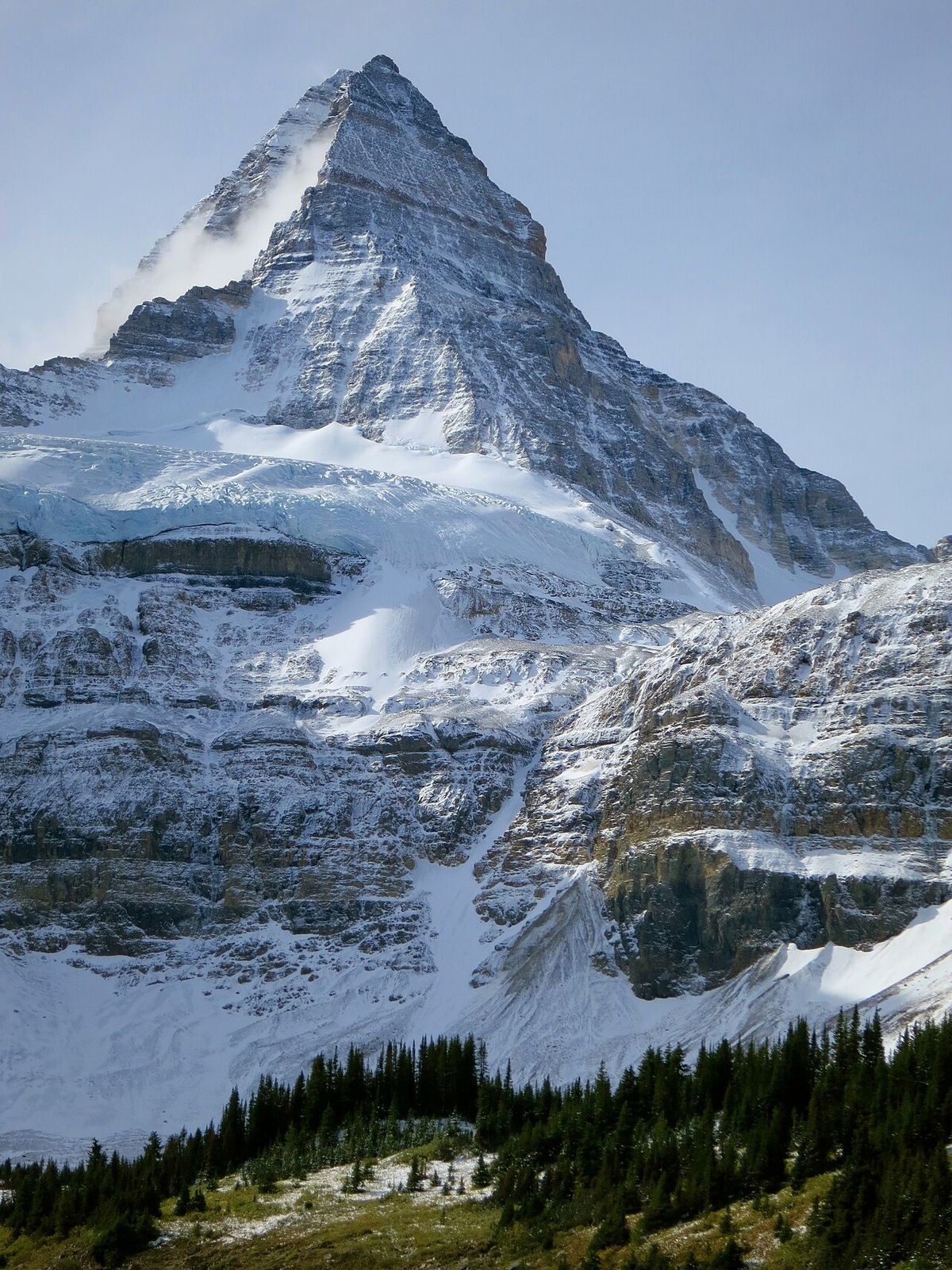
Mount Assiniboine is a prominent pyramidal peak located on the Continental Divide, straddling the border between British Columbia and Alberta in the Canadian Rockies. At an elevation of 3,618 metres (11,870 feet), it is the highest peak in the Southern Continental Ranges and is often nicknamed the "Matterhorn of the Rockies" for its striking resemblance to the famous Alpine peak. The mountain is the centrepiece of a protected wilderness area that includes Mount Assiniboine Provincial Park in British Columbia and Banff National Park in Alberta. Its remote location, accessible only by a long hike, horse pack, or helicopter, makes it a premier destination for mountaineers and backcountry enthusiasts seeking a classic Canadian wilderness experience.
Geography and Setting
Mount Assiniboine is situated precisely on the Great Divide, the hydrological boundary separating watersheds that drain to the Pacific Ocean from those that drain to the Atlantic and Arctic Oceans. The mountain's pyramidal form is a product of extensive glacial carving, and it rises dramatically nearly 1,525 metres (5,003 feet) above the shores of Lake Magog to its south. This immense vertical relief contributes to its formidable and classic profile. The peak is the apex of the Southern Continental Ranges, a major subdivision of the Canadian Rockies that includes other notable groups like the Park and Kananaskis Ranges. The surrounding landscape is characterized by deep U-shaped valleys, alpine meadows, and numerous other glacial lakes, all within a largely roadless wilderness area.
The mountain's jurisdiction is split between two of Canada's most significant protected areas. Its eastern slopes fall within the boundaries of Alberta's Banff National Park, Canada's first national park established in 1885. This binational park management requires cooperation between Parks Canada and BC Parks. The primary access corridor is from the Alberta side via the Sunshine Village ski area, leading to a 27-kilometre (17-mile) trail to the core area around Lake Magog.
Naming and Indigenous Connection
The mountain was named in 1885 by the eminent geologist and surveyor George Mercer Dawson during his explorations for the Geological Survey of Canada. Observing the peak from Copper Mountain, Dawson noted a distinctive plume of cloud streaming from its summit. This phenomenon reminded him of the smoke rising from the teepees of the Assiniboine people, a First Nation whose traditional territories spanned parts of the northern Great Plains and into southern Saskatchewan and Alberta. The name was officially adopted and has remained in use since. The Assiniboine, also known as the Nakoda, are a Siouan-speaking people with a rich history and culture, though their traditional lands were primarily east of the Continental Divide.
While the mountain itself may not have been a central site for the Assiniboine, its naming serves as a geographic acknowledgment of their presence in the broader region. The act of naming significant landscape features after Indigenous peoples was a common practice by early European explorers and surveyors in Canada. Today, the name Mount Assiniboine is a permanent fixture on maps, linking the natural history of the Rockies with the human history of the Plains. The visual inspiration for the name, the cloud plume, remains a common sight due to the peak's height and exposure to prevailing weather systems.
Mountaineering History
The first successful ascent of Mount Assiniboine was accomplished in the summer of 1901 by a party led by the British mountaineer and author James Outram, guided by Swiss mountaineers Christian Bohren and Christian Hasler. This climb was a significant early achievement in Canadian alpine history, given the peak's technical difficulty and remote location. For decades, the mountain presented a formidable challenge with no easy scrambling routes to its summit. A major milestone was reached in 1925 when the Italian-Canadian guide and trail builder Lawrence Grassi made the first recorded solo ascent, demonstrating a high level of skill and self-reliance.
In the century since, the mountain has seen numerous ascents via its various ridges and faces, though it remains a serious and committing objective. The easiest and most common climbing routes are the North Ridge and the North Face, both rated at YDS 5.5 (moderately difficult rock climbing). These routes are typically approached from the Hind Hut, an alpine shelter located on the north side of the mountain. The centenary of the first ascent was commemorated on August 27, 2001, when Lonnie Bohren, the granddaughter of guide Christian Bohren, along with three other climbers, successfully reached the summit in a symbolic tribute to the original pioneers.
Access and Recreation
Reaching the core area around Mount Assiniboine is an undertaking that preserves its wilderness character. There are no roads into Mount Assiniboine Provincial Park. The standard approach for hikers and backpackers is a 27-kilometre (17-mile) trail from the Sunshine Village ski area in Banff National Park, which typically takes a full day of six hours or more to hike. For many years, mountain biking was a permitted alternative for covering this distance more quickly, but this practice has been discontinued to reduce potential encounters between cyclists and grizzly bears, which frequent the area. The primary alternatives to hiking are travelling by horse pack, using outfitters who operate in the region, or arriving by helicopter, which offers a quick but expensive access option for visitors and supplies to the lodge at Lake Magog.
The area offers a wide range of recreational opportunities beyond mountaineering. The network of trails around Lake Magog, Sunburst Lake, and Cerulean Lake provides exceptional day hiking and multi-day backpacking routes with stunning alpine scenery. Key activities in the summer and early fall include wildlife viewing (for species like grizzly bear, elk, and mountain goat), photography, and fishing in the alpine lakes. In the winter, the area transforms into a destination for backcountry ski touring and snowshoeing, though access is even more challenging and conditions are severe.
- Primary Access Trail: 27 km from Sunshine Village to Lake Magog.
- Travel Methods: Hiking, horse packing, or helicopter.
- Prohibited Activity: Mountain biking (to minimize grizzly bear conflict).
- Key Destination: Lake Magog campground and Mount Assiniboine Lodge.
- Summer Activities: Hiking, climbing, fishing, photography.
- Winter Activities: Backcountry ski touring and snowshoeing.
Geology and Natural Features
Mount Assiniboine is composed primarily of sedimentary rock layers that were thrust upward and later sculpted by glaciers during the Pleistocene ice ages. The peak is a classic example of a glacial horn, formed where several cirque glaciers eroded the mountain from different sides, leaving a sharp, pyramidal summit. The predominant rock is limestone and dolomite from the Cambrian and Devonian periods, which gives the mountain its characteristic pale grey colour. The surrounding valleys, such as the Valley of the Rocks, are filled with glacial till and moraines, evidence of the immense ice sheets that once covered the region.
The alpine environment around Mount Assiniboine supports a fragile ecosystem adapted to short growing seasons and harsh weather. Alpine meadows, known as heather meadows, bloom with wildflowers in July and August. The area is part of important wildlife corridors, particularly for wide-ranging species like the grizzly bear. The aquatic ecosystems are centred on the clear, cold lakes fed by glacial meltwater, including Lake Magog, Sunburst Lake, and Cerulean Lake. These lakes are oligotrophic, meaning they are low in nutrients and support specific types of aquatic life. The entire region is subject to the extreme continental climate of the Rockies, with long, cold winters and brief, cool summers where weather can change rapidly.
Conservation and Management
The conservation of the Mount Assiniboine area is a collaborative effort between two provincial and federal agencies. The adjoining portions within Banff National Park are managed by Parks Canada under the National Parks Act, which emphasizes ecological integrity. This joint management requires coordination on issues like wildlife management, visitor use, and fire suppression. The area is designated as a UNESCO Canadian Rocky Mountain Parks World Heritage Site, recognizing its outstanding natural beauty and geological significance.
Management priorities include protecting sensitive alpine vegetation, managing human-wildlife conflicts (especially with grizzly bears), and maintaining the wilderness experience by limiting development and commercial activity. Visitor numbers are managed through a quota system for the campgrounds and the lodge to prevent overcrowding. All garbage must be packed out, and open fires are generally prohibited to protect the environment. The prohibition on mountain biking on the main access trail is one example of a management decision made to prioritize wildlife safety and wilderness preservation over recreational convenience, ensuring the long-term health of the ecosystem.
Questions about Mount Assiniboine
How do you get to Mount Assiniboine?
Access to the Mount Assiniboine area is wilderness-based and does not involve roads. The primary method is a 27-kilometre (17-mile) hike from the Sunshine Village ski area in Banff National Park, which takes approximately six hours or more. The other main options are to travel by horse pack with an outfitter or to fly in by helicopter. Mountain biking on the main trail is no longer permitted.
Can you climb Mount Assiniboine without technical gear?
No, there are no non-technical scrambling routes to the summit of Mount Assiniboine. All ascents require mountaineering skills and equipment. The easiest routes, such as the North Ridge and North Face, are rated YDS 5.5, which involves moderately difficult rock climbing and typically requires ropes, helmets, and other protective gear. Proper training and experience are essential.
What is there to do at Mount Assiniboine besides climbing?
The area offers extensive backcountry hiking on a network of trails connecting alpine lakes like Magog, Sunburst, and Cerulean. Visitors enjoy wildlife viewing, photography, and fishing. The historic Mount Assiniboine Lodge provides accommodation. In winter, the area is a destination for backcountry ski touring and snowshoeing, though access is more challenging.
Where is Mount Assiniboine located?
Mount Assiniboine is located on the Great Divide, which forms the border between British Columbia and Alberta in Canada. It is a pyramidal peak mountain situated within both Mount Assiniboine Provincial Park in British Columbia and Banff National Park in Alberta. The mountain stands at 3,618 metres, making it the highest peak in the Southern Continental Ranges of the Canadian Rockies. Access to the area is limited, requiring a six hour hike or horse pack trip over 27 kilometres from the nearest trailhead. Alternatively, visitors can arrive by helicopter, as biking is now disallowed to reduce potential encounters with grizzly bears.
Why is Mount Assiniboine called the Matterhorn of the Rockies?
Mount Assiniboine is nicknamed the 'Matterhorn of the Rockies' due to its striking resemblance to the well-known Matterhorn in the Alps. Its prominent pyramidal peak shape closely mirrors that of the famous European mountain. This visual similarity has made the comparison a longstanding and popular one. The mountain rises dramatically nearly 1,525 metres above the nearby Lake Magog, further accentuating its impressive and classic form. The nickname effectively captures its distinctive and majestic silhouette within the Rocky Mountain landscape.
When was Mount Assiniboine first climbed and by whom?
Mount Assiniboine was first climbed in the summer of 1901 by a party consisting of James Outram, Christian Bohren, and Christian Hasler. This initial successful ascent was a significant event in the mountaineering history of the Canadian Rockies. The 100th anniversary of this climb was commemorated on August 27, 2001, when a group including Bohren's granddaughter, Lonnie, made another successful ascent. The first solo ascent of the mountain was achieved by Lawrence Grassi in 1925. There are no scrambling routes on Mount Assiniboine, with the easiest mountaineering routes being the North Ridge and North Face, rated at YDS 5.5.
Sources and further reading
- Mount Assiniboine (Wikipedia)
- Mount Assiniboine Park (bcparks.ca)
- Camping | Assiniboine Lodge (assiniboinelodge.com)
- Assiniboine Park Backpacking Guide (mariaadey.com)
- Backpacking Mount Assiniboine: Complete Hiking Guide (skyestoury.com)
Checked by the Your Space Hamilton desk. Last updated 2026-10-23.