Regina, Saskatchewan
Regina is the capital city of the Canadian province of Saskatchewan and the province's second-largest city after Saskatoon. It serves as the commercial centre for southern Saskatchewan and is governed by the Regina City Council. The city's origins trace back to its designation as the seat of government for the North-West Territories in 1882, and it was later proclaimed the provincial capital in 1906. With a 2021 census population of 226,404 within the city and 249,217 in its metropolitan area, Regina is a significant political, cultural, and economic hub on the prairies.
History and establishment
The site of Regina was originally known as Wascana, from the Cree word Oskana meaning 'Buffalo Bones,' a name derived from the collections of bison bones near a small spring run-off creek. In 1882, Edgar Dewdney, the lieutenant-governor of the North-West Territories, selected this arid and featureless grassland over more developed communities like Battleford, Troy, and Fort Qu'Appelle as the territorial seat of government. This decision was controversial and a national scandal due to Dewdney's personal landholdings adjacent to the future Canadian Pacific Railway line at Pile-of-Bones, creating an obvious conflict of interest. Princess Louise, the wife of the Governor General of Canada, proposed renaming the settlement Regina in honour of her mother, Queen Victoria, and the town's early development consisted of wooden shanties and tents clustered near the designated CPR station site some 3.2 kilometres east of Dewdney's land. Regina gained national prominence in 1885 when it served as a staging point for troops during the North-West Rebellion, with troops transported by train as far as Qu'Appelle Station before marching northwest, and later as the location for the trial and execution of the rebellion's leader, Louis Riel, which brought the new Regina Leader newspaper to national prominence.
Regina was incorporated as a city on 19 June 1903, with MLA James Hawkes declaring it had the brightest future of any place in the North West Territories. Just a few years later, on 23 May 1906, the first provincial government led by Premier Walter Scott proclaimed Regina the capital of the newly created province of Saskatchewan. The monumental Saskatchewan Legislative Building was constructed between 1908 and 1912, solidifying the city's administrative role. From 1920 to 1926, the city employed a form of proportional representation known as the Single Transferable Vote to elect its councillors from one at-large district, with each voter casting a single ranked transferable ballot. Regina grew rapidly until the beginning of the Great Depression in 1929, though it only reached a small fraction of the originally anticipated population explosion for the new province's centre.
Political activism and the Great Depression
The Great Depression of the 1930s hit Regina and the prairie provinces particularly hard, halting the city's earlier growth as Saskatchewan's agrarian economy focused on dry land grain farming suffered. This period of economic hardship fostered significant political activism and experimentation as people sought to adjust to new, reduced economic realities. In 1933, Regina hosted the first national convention of the Co-operative Commonwealth Federation, the predecessor to the New Democratic Party, at which the party adopted its foundational Regina Manifesto outlining socialist goals. Two years later, in 1935, the city was the scene of the Regina Riot, a violent confrontation between police and participants of the On-to-Ottawa Trek, a protest by unemployed workers, which brought further attention during the drought and depression. These events cemented Regina's reputation as a centre for political movements, including the co-operative movement and the early advocacy for public healthcare, which would later be championed by Saskatchewan Premier Tommy Douglas after he led the CCF to provincial victory in 1944. The city's people adjusted to the economic realities by ascribing to these cooperative ideals, and Saskatchewan never fully recovered the early promise of its boom years, with Regina's growth slowing and at times reversing thereafter.
Geography, climate, and environment
Regina is located on a broad, flat, and treeless plain immediately east of Moose Jaw, with few topographical features other than Wascana Creek. The city's landscape is almost entirely hand-planted, featuring some 300,000 trees and shrubs, with American elms being the dominant species along boulevards and in residential yards. The city's primary topographical feature is Wascana Lake, a decorative lake created south of the downtown core by damming the small Wascana Creek with a dam a block and a half west of the later Albert Street Bridge. Newer residential subdivisions in the northwest and southeast often feature decorative landscaped lagoons instead of traditional spring runoff storm sewers, and the pattern of school grounds has been rethought with artificial hills and parks. The urban forest faces a significant threat from Dutch elm disease, which has spread to the Canadian prairies and has the potential to wipe out Regina's elm population, though it is currently controlled by pest management programs and the planting of resistant species.
Regina experiences a warm summer humid continental climate with more than 70 percent of its annual precipitation falling in the warmest six months, bordering on a Dwb classification. The city has cold, dry winters and warm summers, prone to extremes at all times of the year. The average annual temperature is 3.1 °C, and the city receives an average annual precipitation of 389.7 millimetres, with precipitation heaviest from May through August and June being the wettest month with an average of 75 millimetres. Regina holds provincial temperature records, with the lowest recorded temperature being -50.0 °C on 1 January 1885 and the highest being 43.9 °C on 5 July 1937. The city is located in the NRC Plant Hardiness Zone 3b, which informs the types of vegetation that can survive its climate extremes.
Cityscape and notable neighbourhoods
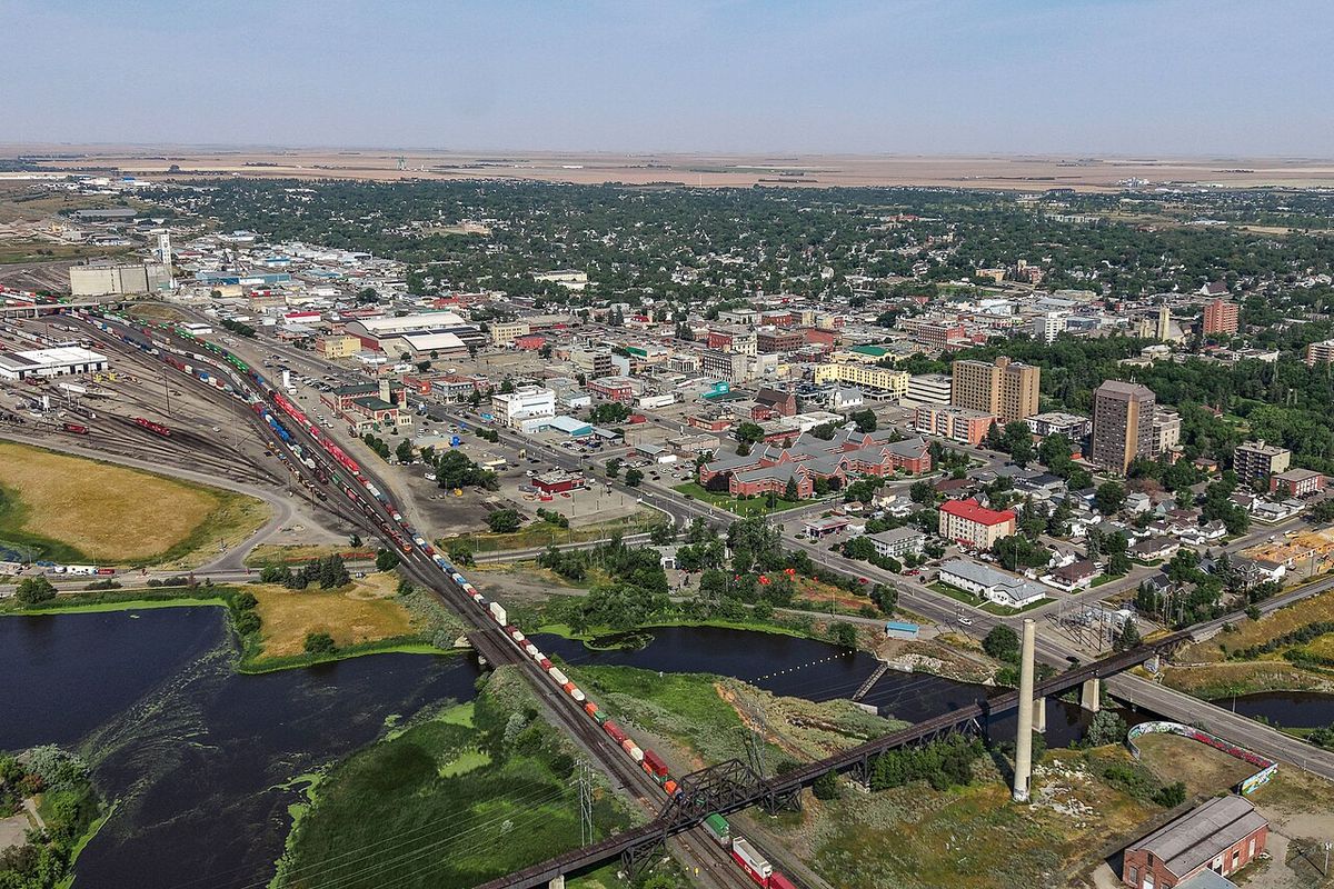
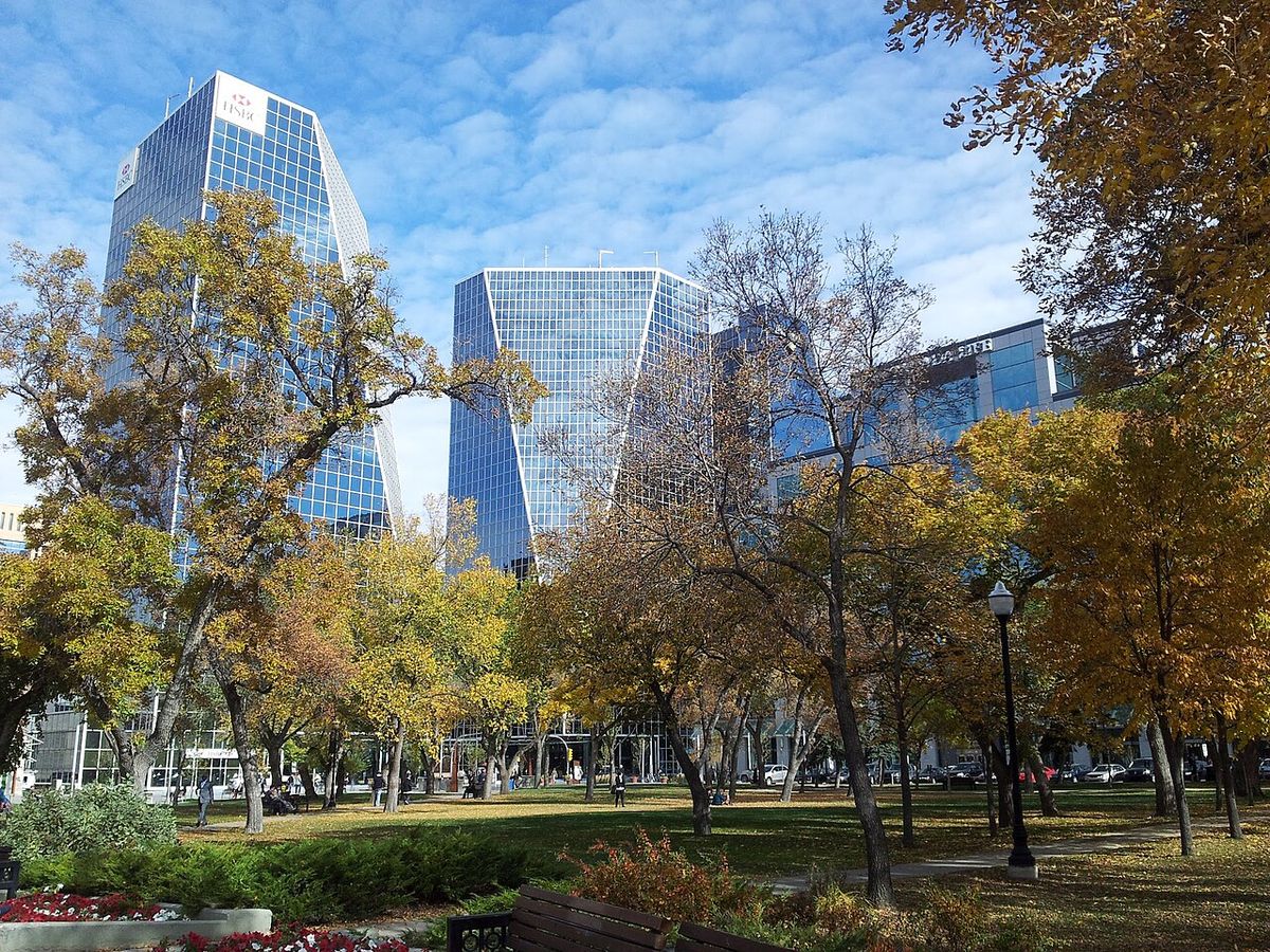
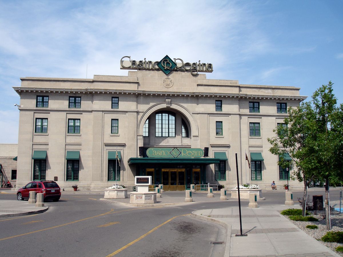
Regina's cityscape includes a mix of historic neighbourhoods, a central business district deemed Market Square, and redeveloping industrial areas. The downtown core, once depleted by the move of retail and entertainment to the periphery beginning with shopping malls in the 1960s and big-box stores in the 1990s, has seen revitalization through adaptive reuse projects. The disappearance of Simpson's, Eaton's, and Army & Navy department stores left only the Hudson's Bay Company downtown, which has since been converted into offices, while the former CPR train station now houses Casino Regina and its show lounge. The Warehouse District, immediately north of the CPR line and the central business district, has been transformed from a freight reception zone into a desirable precinct of retail, nightclubs, and residential lofts as historic warehouses are converted. Several residential neighbourhoods are of particular historical or social note, representing precincts beyond the historic city centre.
- The Crescents: An affluent historic area immediately north of Wascana Creek west of the Albert Street bridge and dam, featuring homes from the early 20th century.
- Lakeview: Adjacent to the provincial Legislative Building, this neighbourhood contains some imposing mansions dating from before the First World War through the post-war boom of the 1920s.
- Cathedral Area: A character neighbourhood known for its historic homes and community.
- Germantown: Originally a poor and ill-serviced area settled by continental Europeans.
- The remaining original town: The residential portion between the CPR tracks and Wascana Lake.
The city is surrounded by the Rural Municipality of Sherwood No. 159, and several nearby towns have evolved into commuter satellites due to excellent roads, including White City, Emerald Park, Balgonie, Pense, Grand Coulee, Pilot Butte, and Lumsden in the Qu'Appelle Valley about 16 kilometres north. Regina Beach on Last Mountain Lake remains a popular summer destination and commuter town a 30-minute drive away, and Fort Qu'Appelle in the Qu'Appelle Valley is a summer vacation venue of choice on the Fishing Lakes. From its first founding, Reginans have retired to the nearby Qu'Appelle Valley on weekends and for holidays, and towns like Indian Head attract commuters with their professional services and retail establishments, having been used for filming outdoor sequences for the CBC television series Little Mosque on the Prairie.
Cultural institutions, attractions, and arts
Regina's cultural life is anchored by the University of Regina and the expansive Wascana Centre park, which was established in 1962 to govern the 930-hectare urban park and legislative grounds. This centre, created around Wascana Lake, makes Regina enjoyable for residents and remains the metropole for farmers and neighbouring towns, fulfilling the early planners' vision by taking advantage of the opportunity to create a decorative lake. A 100-year master plan for the centre was initially developed by World Trade Centre architect Minoru Yamasaki and landscape architect Thomas Church as part of developing a new University of Saskatchewan campus, and the plan has been revised every five to seven years since, most recently in 2016. The city supports a substantial arts scene in music, theatre, and dance, bolstered by university faculties, which has attracted notable artistic talent such as the Regina Five artists who gained national fame in the 1950s while at Regina College. Other artists with significant international reputations from or once in Regina include Donald M. Kendrick, Bob Boyer, and Joe Fafard, and the long-established MacKenzie Art Gallery has moved from cramped quarters adjacent to Darke Hall on the College Avenue Campus to a large building at the southwest corner of the provincial government site at Albert Street near 23rd Avenue.
Annual festivals in and near Regina through the year include the Regina International Film Festival, the Cathedral Village Arts Festival, and the Spring Celebration Powwow held by the First Nations University. Key cultural and educational institutions located within Wascana Centre provide a dense concentration of attractions, and older buildings have been adaptively reused for cultural purposes, such as the old Normal School now housing the Canada Saskatchewan Production Studios and the old Post Office on the Scarth Street Mall hosting the Globe Theatre. The city's cultural infrastructure also includes the Royal Saskatchewan Museum, the Saskatchewan Science Centre, the Regina Conservatory in the original Regina College buildings, and the Saskatchewan Centre of the Arts, all contributing to a substantial cultural offering for a city of its size. The efforts to create and maintain Wascana Centre have yielded favourable results for the city's quality of life, despite the improbable setting compared to other more likely sites originally considered for the territorial capital.
Modern development, economy, and heritage
Regina's modern development has been shaped by suburban expansion, downtown revitalization, and the preservation of heritage buildings amidst periods of loss. The proliferation of shopping malls from the 1960s and big-box stores from the 1990s on the city's periphery initially drew activity away from the core, along with a drift of entertainment venues and all but one downtown cinema to the outskirts. However, concerted efforts have brought life back downtown through conversions of historic buildings for office, retail, and residential use, with the Cornwall Centre and downtown restaurants now drawing people back. The city's economy, historically tied to agriculture and government, experienced a new period of strong growth starting around 2007 as global demand increased for Saskatchewan's agricultural and mineral resources, following the long slump after the Great Depression.
Several significant heritage buildings were lost in the mid-20th century from 1945 through approximately 1970, including Knox United Church demolished in 1951, the Romanesque Revival city hall in 1964 replaced by a failed mall now used as federal office space, and the 1894 Supreme Court of the North-West Territories building at Hamilton Street and Victoria Avenue in 1965. In contrast, other landmarks have been preserved and adaptively reused through strict covenants and restoration projects, such as the long-imperilled Government House saved in 1981 after decades of neglect and returned to viceregal use. The former Anglican diocesan property at Broad Street and College Avenue is being redeveloped maintaining the integrity of its buildings and St Chad's School, and the former Sacred Heart Academy building adjacent to the Roman Catholic Cathedral has been converted into townhouses. The long-term planning embodied in Wascana Centre and the reuse of historic structures in the Warehouse District demonstrate a commitment to balancing growth with heritage and quality of life for residents, fulfilling the early planners' vision for the city.
Population, metropolitan area, and commuter communities
Regina's population has grown steadily since its founding, though not at the explosive rate once predicted during its early boom years as the anticipated metropole for the Canadian plains. The city's growth slowed significantly during the Great Depression and the subsequent reorganization of the prairie agrarian economy from small family farms to larger multi-section landholdings necessary for economic viability. The surrounding rural municipalities and commuter towns contribute to the region's overall population and economic activity, with many nearby towns like Qu'Appelle, Indian Head, and Rouleau experiencing population shifts as they become commuter satellites or locations for film production, as seen with Corner Gas. The following table shows the population growth for the City of Regina over recent decades, illustrating its steady expansion.
The demographic and economic shifts in the latter half of the 20th century saw many small towns in the region steadily lose population from the 1940s onward as farming consolidated, with towns near Regina losing population as the agrarian economy reorganised itself. In recent decades, improved transportation infrastructure has allowed some of these towns to reinvent themselves as commuter communities for Regina, contributing to the interconnectedness of the metropolitan region. Towns like White City and Emerald Park are quasi-suburbs, while Balgonie, Pilot Butte, and Lumsden offer residential alternatives in the Qu'Appelle Valley, and Indian Head attracts commuters with its professional services and retail establishments, having been used for filming Little Mosque on the Prairie. Qu'Appelle, once intended to be the metropole for the District of Assiniboia, saw interest decline after Highway 10 bypassed it but has recently seen more interest as a place to live again, and Rouleau bustled with film crews in the summer months during the production of Corner Gas.
Questions about Regina, Saskatchewan
Why is Regina the capital of Saskatchewan?
Regina was designated the capital of Saskatchewan when the province was created in 1905. The city had already served as the seat of government for the North-West Territories since 1882, selected by Lieutenant-Governor Edgar Dewdney despite controversy over his personal landholdings. On 23 May 1906, the first provincial government, led by Premier Walter Scott, formally proclaimed Regina the provincial capital. The monumental Saskatchewan Legislative Building was constructed shortly thereafter, between 1908 and 1912, to house the new provincial government and secure the city's administrative importance.
What was the Regina Cyclone?
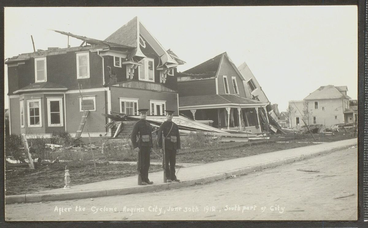
The Regina Cyclone was a devastating tornado that struck the city on 30 June 1912. It remains the deadliest tornado in Canadian history, causing 28 fatalities when the city's population was 30,213. The tornado formed south of the city and tore a swath through the residential area between Wascana Lake and Victoria Avenue, continuing through the downtown business district, rail yards, warehouse district, and northern residential area. The disaster attracted national attention and relief efforts, including a benefit performance by a theatrical group featuring a young Boris Karloff and donations from performances in Saskatoon.
What does the name Regina mean?
Regina is the Latin word for 'Queen.' The site was originally known by its Cree name, Wascana, meaning 'Buffalo Bones,' a reference to the bison bones found near a small spring run off creek. In 1882, it was renamed Regina in honour of Queen Victoria. The name was proposed by Queen Victoria's daughter, Princess Louise, Duchess of Argyll, who was the wife of the Governor General of Canada, the Marquess of Lorne. This renaming occurred when the location was designated as the territorial seat of government for the North West Territories, securing its future importance.
What is the Regina Manifesto?
The Regina Manifesto was the foundational programme of the Co operative Commonwealth Federation, the predecessor to the New Democratic Party. It was adopted at the party's first national convention, held in Regina in 1933. The manifesto set out the new party's socialist goals during the Great Depression, which hit the Canadian Prairies particularly hard. This document symbolized Regina's role as a centre for political activism and experimentation, as people adjusted to reduced economic realities by supporting ideas like the co operative movement and public healthcare, which later influenced Canadian policy.
What is Wascana Centre?
Wascana Centre is a 930 hectare urban park and legislative grounds in Regina, created around Wascana Lake. The lake was formed by damming Wascana Creek early in the city's planning to add a decorative feature to the treeless plain. Established in 1962 and governed by the Wascana Centre Authority, it contains major institutions like the Provincial Legislative Building, both campuses of the University of Regina, the First Nations University of Canada, the Royal Saskatchewan Museum, and the MacKenzie Art Gallery. A 100 year master plan was developed for the area, which is revised every five to seven years, making it a central attraction for residents and visitors.
What is the climate like in Regina?
Regina experiences a warm summer humid continental climate, with cold, dry winters and warm summers prone to extremes. The average daily temperature is 3.1 degrees Celsius, and average annual precipitation is 389.7 millimetres, with over 70 percent falling in the warmest six months. June is the wettest month, averaging 75 millimetres of precipitation. The city holds provincial temperature records, with the highest ever recorded being 43.9 degrees Celsius in July 1937 and the lowest being minus 50.0 degrees Celsius in January 1885. Regina is also classified as Plant Hardiness Zone 3b.
Sources and further reading
- Regina, Saskatchewan (Wikipedia)
- Why Regina? (saskpolytech.ca)
- Life in Regina, Saskatchewan (luthercollege.edu)
Checked by the Your Space Hamilton desk. Last updated 2026-10-20.