Prince George, British Columbia
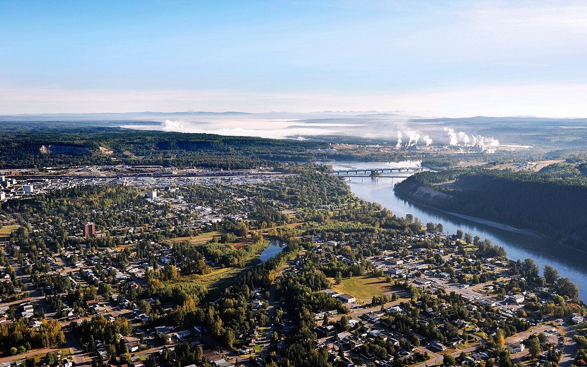
Prince George is a city in central British Columbia, Canada, situated at the confluence of the Fraser and Nechako rivers. With a population of 76,708 and a metropolitan area of 89,490, it is the largest city in Northern British Columbia and serves as the region's economic and service hub, often called the province's 'northern capital'. The city's economy has long been anchored by the forest products and mining industries, supported by its role as a centre for higher education, health care, and government services. Prince George's history is deeply intertwined with the Lheidli T'enneh First Nation and the arrival of the Grand Trunk Pacific Railway, which shaped its early development.
Early History and Indigenous Heritage
The area now known as Prince George is the centuries-old homeland of the Lheidli T'enneh First Nation, whose name means 'people of the confluence of the two rivers'. European presence began with the establishment of the Fort George fur trading post by Simon Fraser of the North West Company in 1807, named in honour of King George III. Throughout the 19th century, this Hudson's Bay Company post remained a relatively isolated outpost, with the Lheidli T'enneh village situated nearby for ease of trade. The band's historical association with the site is recognized today, with the Fort George Indian Band being the same community. The Lheidli T'enneh name began to see official use around the 1990s, and the band's traditional territory is now formally acknowledged by institutions like Northern Health.
Railway Boom, Land Acquisition and City Foundation
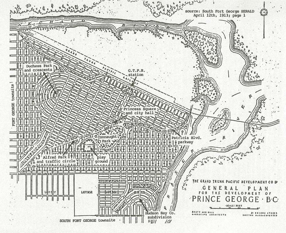
The city's modern origins are rooted in railway speculation and land development between 1909 and 1915. After the Grand Trunk Pacific Railway announced its route, rival land companies developed the townsites of South Fort George and Fort George Townsite. Speculation drove rapid growth, and by 1913 each community had about 1,500 residents as thousands of rail construction workers arrived. The railway ultimately purchased 553 hectares of Lheidli T'enneh Reserve No. 1 land between the two townsites to establish its own station and community, which it named Prince George. The townsite was cleared in May 1913, and the first train arrived in 1914. Amidst legal disputes and negotiations, the railway's townsite was incorporated as the City of Prince George on March 6, 1915. The name was chosen to distinguish it from the older settlements and to honour royalty, either King George V or his son, Prince George, Duke of Kent, with residents voting 153 to 13 in a May 1915 plebiscite to confirm the name.
The acquisition of the Lheidli T'enneh land was a contentious process marked by prolonged negotiations and pressure from the railway, developers, and government agents. After several votes and refusals, the Fort George Indian Band agreed in November 1911 to sell the reserve for $125,000, with a quarter paid immediately and $25,000 earmarked for construction on Reserves No. 2 and 3 and the preservation of the original village cemetery. The band committed to relocate by June 1912 to the new site at Shelley, which was less fertile and more isolated. Delays in constructing the new village and the withholding of payments when members planted crops for winter created hardship. The old village was deliberately destroyed by fire in 1913 to prevent reoccupation, an act reported by the Fort George Herald and described in Indian Agent W.J. MacAllan's accounts as a deliberate tactic to force the band members out. The original village site later became Fort George Park, renamed Lheidli T'enneh Memorial Park in 2015, with the cemetery becoming Reserve No. 1A.
20th Century Growth, War and Industry
The early city faced immediate setbacks from the First World War, which drew away manpower and halted construction of the Pacific Great Eastern Railway, leading to a massive drop in population. The Spanish flu epidemic of 1918 took at least fifty lives in the area, including First Nations leaders. The 1920s and 1930s were defined by the Great Depression, which saw lumber production in the region fall from 105 million board feet in 1929 to only 15 million board feet by 1932. Unemployed men were housed in relief camps east of the city, which became centres for labour protests and sit-ins organized by the Communist-sympathizing National Unemployed Workers Association. Aviation began to develop during this period, with seaplanes landing on Central Avenue in the 1920s and Prince George becoming a hub for air mail to northern communities, leading to the development of an airport by Carney Hill and the selection of the site for the current Prince George Airport in 1939.
The Second World War brought Army Camp Prince George, which housed up to 6,000 soldiers from March 1942 to October 1943, providing a major economic boost to local businesses. The camp featured barracks, dining halls, wet canteens, and rifle and artillery ranges, with several of its buildings repurposed after the war, such as the former transportation building now used by the Community Arts Council. The post-war European reconstruction boom created skyrocketing demand for lumber, propelling Prince George's economy forward based on its abundant spruce forests and sawmills. The completion of key transportation links solidified the city's role as a regional hub, with the Pacific Great Eastern Railway finally connecting to the CN line at Prince George in 1952 after 40 years of construction, and Highways 16 and 97 also being completed. This industrial growth spurred suburban expansion into new subdivisions like Spruceland, Lakewood, Perry, and Highglen, requiring new schools and housing. The city's boundaries were significantly extended in 1975 through amalgamation with South Fort George, the Hart area to the north, and Pineview to the south. Other mid-century developments included the 1952 opening of Canadian Forces Station Baldy Hughes, a NORAD Pinetree Line radar station 35.9 kilometres southwest of the city that operated until 1988, and the 1953 incorporation of the remaining Fort George Townsite into the city.
Geography, Climate and Environmental Challenges
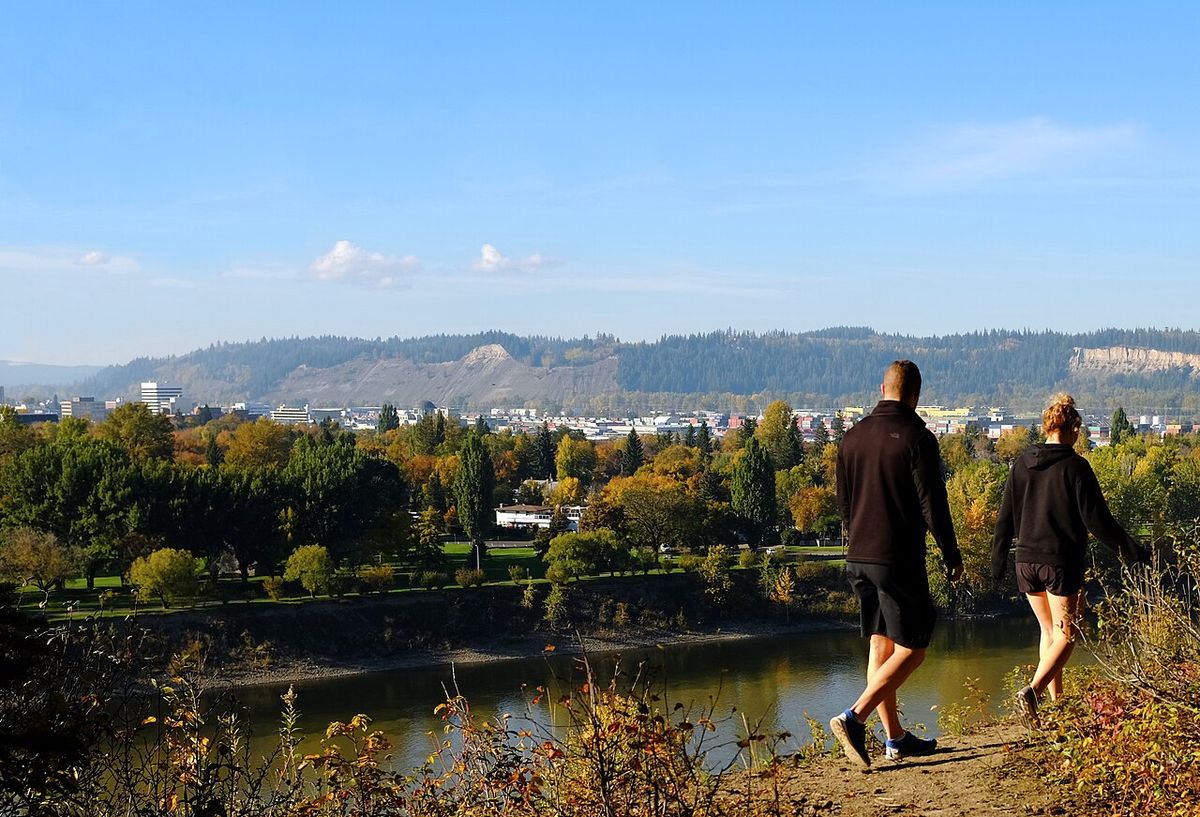
Prince George is located on the traditional territory of the Lheidli T'enneh at the meeting of the Fraser and Nechako rivers, a setting that defines its geography and some of its environmental challenges. The low-lying areas near the river confluence are prone to seasonal flooding, particularly when ice jams form on the rivers which can freeze. A major flood event occurred in late 2007 and continued into January 2008 when an ice jam more than 6 kilometres long formed on the Nechako River, causing widespread flooding and leading the city to declare a state of emergency on December 11, 2007. Faster runoff due to the devastation of nearby lodgepole pine forests by the mountain pine beetle was identified as a contributing factor to the severity of the flooding. The city is surrounded by forests and numerous lakes, providing the natural resources that have historically driven its economy and that continue to offer extensive recreational opportunities for residents and visitors.
Modern City and Regional Role
Today, Prince George functions as the undisputed service and administrative centre for Northern British Columbia. It hosts the headquarters of the Northern Health authority and is a major centre for post-secondary education. The city offers a full range of urban amenities, including shopping centres, a civic centre, and cultural institutions, while maintaining a reputation for relative affordability compared to larger southern metropolitan areas. Its population has shown steady growth, with Statistics Canada estimates suggesting the city has cracked 100,000 residents, a milestone highlighted by local leadership. Mayor Simon Yu has expressed a desire to see that number double, highlighting ambitions for continued expansion. The city government organizes numerous community events, with a major annual gathering being Canada Day in Lheidli T'enneh Memorial Park on July 1, which attracts an estimated 20,000 people.
The city's economy, while still connected to forestry and mining, has diversified into healthcare, education, transportation, and government services. Prince George Airport serves as a key regional air transport hub. The community balances its industrial base with a strong focus on outdoor recreation and family life, with the city being promoted as a top city for families in 2026. The city manages over 100 parks and provides facilities for sports, arts, and community events, fostering a lively local culture. Downtown features locally owned businesses and specialty shops, though it becomes quiet after business hours, while big-box retail is concentrated in active strip malls outside the core. The city's central location makes it a gateway for travel and exploration in northern British Columbia, offering a wide range of housing options from single-family homes to rural acreages.
Culture, Recreation and Attractions
Prince George offers a diverse array of cultural and recreational activities that leverage its northern setting and community spirit. The city is home to performing arts groups like the Prince George Symphony Orchestra and visual arts centres such as the Two Rivers Gallery, located in a distinctive building exhibiting art from across Canada. Historical and scientific education is provided by The Exploration Place museum, with interactive exhibits focusing on science and nature, and the Central BC Railway & Forestry Museum, which details the importance of the Grand Trunk Pacific Railway. Annual festivals and events are central to community life, including Prince George's Traditional Pow Wow, the PG Exhibition, the West of the Rockies Pro Rodeo, and seasonal celebrations like the WinterLights Festival and Cold Snap.
Outdoor recreation is a major draw, with easy access to hiking and biking trails, freshwater fishing in many lakes and rivers, and cross-country skiing at the Otway Nordic Centre, which maintains extensive trails. The city has several golf courses and is near provincial parks offering camping. A whimsical local landmark is the 8.2 metre tall 'Mr. PG' statue, which greets travellers at the junction of Highways 97 and 16. Notable nearby attractions include the Huble Homestead Historic Site, a preserved early 1900s homestead with interpretive displays, and an observatory featuring one of Canada's largest public telescopes for stargazing.
- Two Rivers Gallery: Modern art gallery in a distinctive building with a variety of Canadian exhibits.
- The Exploration Place: Science and nature museum with interactive and historic exhibits for families.
- Central BC Railway & Forestry Museum: Focuses on the history of the Grand Trunk Pacific Railway and forestry in the region.
- Lheidli T'enneh Memorial Park: Major urban park on the site of the original Lheidli T'enneh village and fur trading post, hosting large events like Canada Day.
- Otway Nordic Centre: Extensive trail network for cross-country skiing and summer biking, maintained for public use.
- Prince George Symphony Orchestra: Presents classical and contemporary music performances throughout the year.
- Huble Homestead Historic Site: An original homestead from the early 1900s located within an hour's drive, with multiple historic buildings.
Demographics and Population Trends
Prince George has experienced consistent population growth since its founding, with significant increases following industrial development in the mid-20th century and ongoing expansion of its service sector. The latest official census figures report a city population of 76,708 and a metropolitan census agglomeration population of 89,490. Recent estimates indicate the city is approaching or has exceeded 100,000 residents, a milestone cited by Statistics Canada and highlighted by local leadership. The following table illustrates the population growth of the city proper over several decades, reflecting periods of industrial boom and regional consolidation, from its railway beginnings to its modern status as a regional capital.
| Year | Approximate Population | Notable Context |
|---|---|---|
| 1941 | 2,027 | Pre-Second World War census figure. |
| 1945 | 3,800 | Post-war growth following the operation of Army Camp Prince George. |
| 1975 | Significant increase | Amalgamation with South Fort George, the Hart, and Pineview extended city boundaries. |
| 2026 Estimate | ~100,000 | Projected milestone cited by city officials and Statistics Canada estimates. |
This growth is driven by its role as a regional hub for healthcare, education, and commerce. Prince George is often called the province's 'northern capital' because it serves as a centre for higher education, health care, and government services. The city provides the main support base for major regional industries like forestry and mining. The city's demographics reflect a working community with a strong connection to resource industries and public services.
Notable Events and Incidents
Beyond its developmental history, Prince George has been the site of several specific events that marked the community. On June 25, 1956, a notable aviation accident occurred when a Lockheed P-38 Lightning fighter plane, bearing Canadian registration CF-HSC and flown by former RAF pilot Frank Samuel Pynn, crashed into a ravine about one kilometre from the city centre shortly after takeoff from Prince George Airport. The crash killed Pynn and his 15-year-old passenger, Jimmy Clarke, with a coroner's inquest concluding Pynn died through his own neglect and disregard for regulations, with alcohol believed to be a factor. The wreckage remains at the site, though most pieces are less than two metres in length. In the field of civic events, the city routinely schedules public activities like drop-in hockey and community gatherings, with a full calendar of events planned for 2026 including the annual Canada Day celebration expected to draw 20,000 people to Lheidli T'enneh Memorial Park. The city also holds general local elections, with nomination periods and informational flyers distributed as part of the municipal democratic process.
Questions about Prince George, British Columbia
What is the population of Prince George, BC?
According to the latest census, the city of Prince George has a population of 76,708 people. The larger metropolitan census agglomeration, which includes surrounding areas, has a population of 89,490. Recent estimates from Statistics Canada and city officials suggest the population is on track to reach or has recently exceeded 100,000 residents. Mayor Simon Yu has expressed a goal of eventually doubling the city's population from this new baseline.
What are the main industries in Prince George?
Mining support services are also a significant industry. In modern times, the economy has diversified considerably. Prince George is a major centre for healthcare, education, transportation, and government services, serving as the regional hub for Northern British Columbia. The city's airport and central location at the junction of major highways and rail lines further support its role in trade and logistics.
What is there to do in Prince George for visitors?
Visitors to Prince George can enjoy a mix of cultural attractions and outdoor activities. Key sites include the Two Rivers Gallery, The Exploration Place museum, and the Central BC Railway & Forestry Museum. The city hosts numerous festivals year-round, such as the PG Exhibition, West of the Rockies Pro Rodeo, and WinterLights Festival. Outdoor enthusiasts have access to hiking, fishing in local lakes and rivers, cross-country skiing at the Otway Nordic Centre, and golf at several local courses. A famous local landmark is the 8.2 metre tall 'Mr. PG' statue at the highway junction, and nearby attractions include the Huble Homestead Historic Site and a public observatory.
What is the significance of the Lheidli T'enneh to Prince George?
The Lheidli T'enneh First Nation, whose name means 'people of the confluence of the two rivers', are the original inhabitants of the land where Prince George is located. Their village was situated at the confluence of the Fraser and Nechako rivers for centuries, next to the Hudson's Bay Company's Fort George trading post. In the early 1900s, the band was displaced from this prime location through a pressured land sale to make way for the Grand Trunk Pacific Railway's townsite, which became the city. This history is formally acknowledged, and the former village site is now Lheidli T'enneh Memorial Park, a central city park and the site of major events like Canada Day.
How did Prince George get its name?
The city was named by the Grand Trunk Pacific Railway when it established its townsite in 1913 to 1914. Historical records cite three possible rationales for the name 'Prince George'. It was chosen to clearly distinguish the new railway town from the older settlements of Fort George and South Fort George. It was also said to honour the recently crowned King George V. A third suggestion was that it honoured Prince George, Duke of Kent, the fourth son of King George V. In a May 1915 plebiscite, residents voted 153 to 13 in favour of the name Prince George over alternatives.
Why is Prince George called the 'northern capital'?
Prince George is called the 'northern capital' because it serves as a centre for higher education, health care, government services, arts and entertainment, sports, and support for major industries such as forest products and mining for the northern region of British Columbia. It is the largest city in Northern British Columbia and functions as a regional hub. This central role fulfills the early promotional vision of George Hammond, who described Fort George as the future hub of the province and the 'Chicago of the north'. The city's importance was cemented with the completion of key transportation links like the Pacific Great Eastern railway and Highways 16 and 97 in 1952, finally establishing it as the hub of British Columbia.
Sources and further reading
- Prince George, British Columbia (Wikipedia)
- Prince George, British Columbia (mycanadatrips.com)
- About Prince George (northernhealth.ca)
Checked by the Your Space Hamilton desk. Last updated 2026-10-24.